Article translated by an automatic translation system. Press here for further information.
Stage from A Laxe to Outeiro
The Concello de Lalín dies on the river Deza and passes the witness to Silleda
Information about the stage 12: Stage from A Laxe to Outeiro
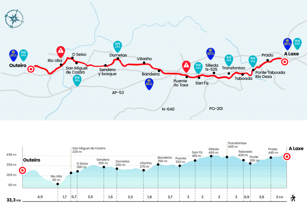
Enlarge map
Points of interest in the stage 12: Stage from A Laxe to Outeiro
The route
- Km 0. A Laxe(Hostel. Bar)
Let's walk the first few meters of the day through the arcén of the N-525. At 400 meters, after entering Vilasoa, we left the national to go on a paved track and some other section of gravel. Both surfaces leave us at the gates of Prado, medium population of Concello de Lalín (Km 2).
- Km 2. Prado(Bars. Shops. Pharmacy)
We traverse it on the road and, at the height of a store, we turn left to leave the asphalt and move between houses. At 700 meters we crossed a road and continued the road, turning 90 degrees to the right and soon another 90 degrees, this time to the left. We go down the paved runway next to the wasted houses of Borralla, where there is a dairy cooperative. Instead of continuing along the reel and turning the curve to the right, we deflected down a road that passes under the viaduct and reaches the old bridge of Taboada on the river Deza (Km 4.6), tributary of the Ulla. It is a medieval stone bridge, with a single Romanesque arch. Data of the S.X (year 912), date which is registered in a rock near the bridge. After crossing, we climbed a rough stretch to the first houses of the parish of Taboada.
- Km 5.5. Taboada
After crossing the widespread stain of houses and the Rural Tavern A Casa de Gerardo (typically Galician house) we reached the N-525. Again, 50 meters away, we leave it on the left to catch a path that reaches some ships, where we turn left hand. We continue along the path to the following population:Transfontao
- Km 7.5. Transfontao(Hostel)
When we arrived next to the front of the chapel we did not find any indication. The road remains straight as it leaves the forest road, it does not stick to the pazo. We go down a rough road – in the rainy season it will be a nice river of water and mud – and we go up to the first houses of the cello capital:Silleda.
- Km 9.5. Silleda(All services)
After crossing part of this town of Trasdeza, we will leave, of course, to the N-525, to finalize it. After passing the post office we left the road down a street by left hand. In thirty meters we go right down one road and back to the national one. The senda-national game bored too much and it doesn't end until we arrived next to a feed manufacturing company called Nudesa. At this point we drifted completely to the left and down a paved runway to reach San Fiz, village of Margaride.
- Km 11.5. San Fiz
After passing the nucleus of houses and a crossing, we turn right and immediately left. So we enter a nice wooded path that crosses a paved runway. We continue on a slightly downward path that passes next to some agricultural vessels and leads to crossing a bridge over an influent of the river Deza, the Toxa (Km 13,5). After the driveway we swivel left and then right. We crossed the N-640 and soon over the AP-53. We continue walking in asphalt and, when we reach the height of some houses, turn right to start later our approach to N-525 on a gravel track. We entered Bandeira in this way. This town has a hostel of pilgrims.
- Km 16.2. Bandeira(All services)
We cross Bandeira parallel to the road and, at the end of the population, a few meters before kilometric point 310, we take to the right the diversion to A Casela. A pictured highway descent, the passage of a stream and a short climb lead us to the first houses of Vilariño, parish of Lamela, Silleda (Km 18). We went off the street and arrived after a mile and a mile straight by a stable and a house (the Jabobeo Cairn marks 30,459 kilometers to Santiago). We resumed the march on a road that died again in a nefarious runway down to the parish of Dornelas and its church of San Martiño.
- Km 21.3. Dornelas(From spring 2015 Casa Leiras: cafeteria and hostel)
We say goodbye to this parish and we go out taking a secondary road to the left hand. We will follow it for a long kilometer to turn left hand at a junction and, shortly to the right, avoiding going to the nearby N-525. The following section is undoubtedly one of the most enjoyable of the day (Km 22,8). It is a mixture between trail and trail running for two kilometers between a vast population of pines, eucalyptus and tojos. It's done the worst way, going off a paved runway that leads us to cross a road. We first arrived at O Seixo (Km 26,3) and then turned right to go down to Castro (bar) (Km 27). In strong descent we link to Ponte Ulla, the next locality and first of the province of A Coruña.
- Km 28.7. Ponte Ulla(Hostel. Bars. Shops)
We premiered it across the Ulla River, which gives it its name and serves as a provincial limit. The Ulla forms the second largest basin in the Galician Community and flows into the Ria de Arosa after a journey of over 130 kilometres. You leave Ponte Ulla on a road, passing under the corridor bridge of the pazo de Vistalegre and we go to the N-525, (one hundred meters before you reach the national there is a detour right hand, signalized, that avoids contact with the N-525 and that goes through the forest with nice views, extends the stage does not reach a kilometer but it is worth it), on the climb and following the highway Before the sign of Ponte de Sarandón we take a path to the right that passes through a tunnel and after hard repecho it leaves a paved runway. This leads us to turn twice in a row towards the right and leads to a forest track, without shadow, and at this stage it involves a touch of grace. It ends on a paved runway that we follow on the left to pass between the fountain and the chapel of Santiaguiño, built in 1676. One more small step and we reached the hostel of Outeiro (parish of Vilanova, Concello de Vedra), which is located in an enviable rural environment and in a strategic position rather than privileged: only 16 kilometers from the cathedral of Santiago.
- Km 33.3. Outeiro(Hostel)
The difficulties
Remarks
In images
What to see, what to do
The hostels

¿Do you want to send any photo of "The Camino de Santiago"?
If you have any photos of "El Camino de Santiago" that you want to share with us, you can send them to us and enlarge the photo gallery
Forum: What pilgrims think about the Camino de Santiago
See all