Article translated by an automatic translation system. Press here for further information.
Ourense to Cea Stage
Until you reach Sartébia, the Camiño Real road picks up
Information about the stage 10: Ourense to Cea Stage
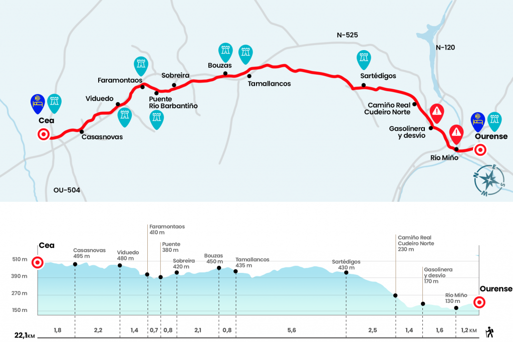
Enlarge map
Points of interest in the stage 10: Ourense to Cea Stage
The route
- Km 0. Ourense(All services)
From Plaza Mayor we take Lamas Carvajal Street to continue straight down Paseo Street to San Lázaro Park. Then through the rustic do Concello we head to the praza Concepción Arenal and we reach the Roman bridge over the Miño (Km 1,2). We will travel its 370 meters in length and continue forward along As Caldas Avenue. At the intersection of the fourth bocacalle, where we see another stone carving of Nicanor Carballo, we turn right by the avenue of Santiago (if we go ahead, we will take the other alternative detailed in the comments section). We continue along this avenue with the tranquility of seeing tiles decorated with a vieira pulling the ground. As soon as we pass the Velasco gas station we turn right onto Camiño Real Cudeiro Sur Street (Km 2,8).
We continue through it and cross the N-525 (Km 3,4). When we reach the Pereira district, we turn left onto Camiño Real Soutelo Street, a rough echo reminiscent of the classic spring cycling calendar. We arrived to a plaza where the church is located and continued the ascension to cross the road again and climb the street Camiño Real Cudeiro Norte. Later on the Camiño da Costa gives us traces of old scraps to drive us, after some horseshoe curves, under the hermitage of San Marcos. On clear days you get nice views, somewhat truncated by the nearby trees, but it doesn't really feel like climbing up after the beating that we're giving. The stone is finished and the floor becomes compact. Soon we arrived at Sartécodes, a series of scattered houses dotted with vineyards and even sheep grazing their breezes.
- Km 6.7. Paraffin
We go to a paved runway and turn right to continue on a road that goes to the road (Km 7.2). At 50 meters we left it on the right, at the foot of the diversion to the Fonte do Santo. The road rises slightly and reaches Outeiros da Forca. We leave behind the last chalés and we go ahead after crossing the road. The Jacobean cairn marks 96,606 to Santiago. Encouragement. After more asphalt, we went down a dirt track to some spacecraft and then down to the N-525. A road on the edge of the national road to Tamallancos.
- Km 12.3. Tamallancos(Bars. Pension. Shops. Pharmacy. ATM)
This service population houses an 18th-century Baroque pazo and the Church of Santa Maria, removed in the 16th century on a Romanesque basis. We left the town and by paved runway we arrived in Bouzas (Km 13.1), town of Concello de Vilamarín.
- Km 13.1. Bouzas(Bar)
We went next to the cover of his modern church of Santiago and then crossed the N-525. We continue along a road, along with a few ruinous orderlies, and after a kilometer and a half long we enter Superira (Km 15,2). We dismissed this village and headed to a beautiful stone bridge, from the thirteenth or fourteenth centuries, over the Barbantiño River. After a district of collapsed houses we reach a junction and, following it on the right, we will enter Faramontaos, a village of the parish of Viña belonging to the Concello de Cea (Km 16,7). At the exit we face a good slope and continue under the N-525 to Viduedo and its chapel of San Pantaleón (Km 18.1).
- Km 18.1. Viduedo(Bar & Outlet)
We followed the national a few meters and left it on the right. On one road we arrive at Casanovas (Km 20,3), where we receive a decorated with a fountain, a bump and a pumpkin and, above all, a comforting indication: “Cea 2 km away.” We continue on a path that winds between pines to cross a road and enter Cea. We passed by the public school and under a bridge of the fast track. Soon we arrived at the hostel, next to the one that highlights the L-shaped Hórreo.
- Km 22.1. Cea(All services)
The difficulties
Remarks
In images
What to see, what to do
The hostels

¿Do you want to send any photo of "The Camino de Santiago"?
If you have any photos of "El Camino de Santiago" that you want to share with us, you can send them to us and enlarge the photo gallery
Forum: What pilgrims think about the Camino de Santiago
See all