Article translated by an automatic translation system. Press here for further information.
Lubian to A Gudiña Stage
Visit A Vilavella and Pereiro at the Concello de A Mosque
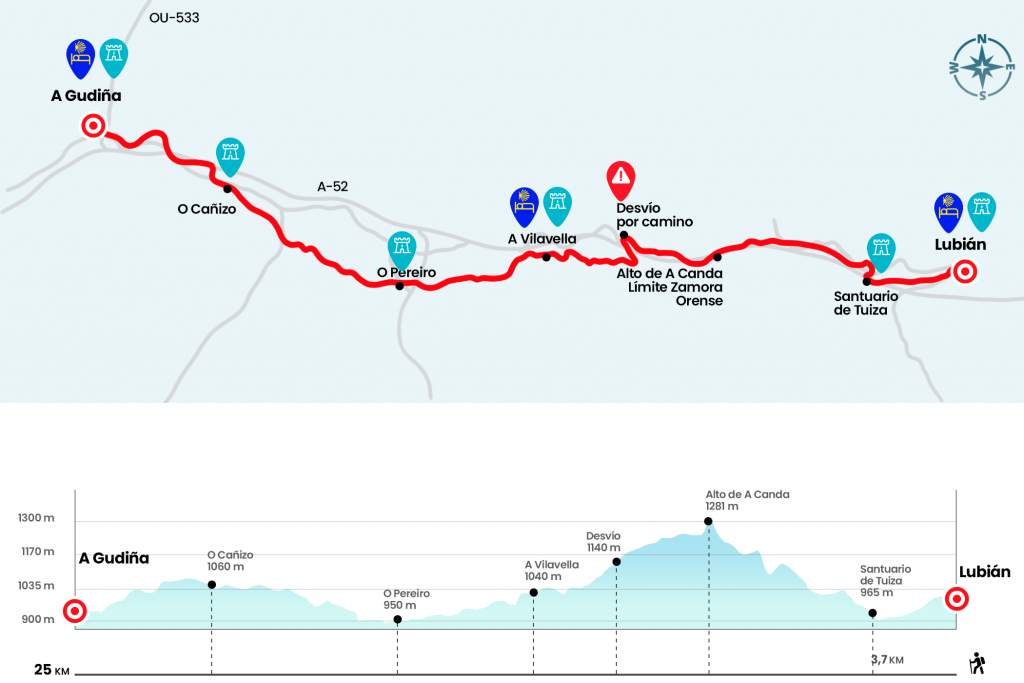
Information about the stage 6: Lubian to A Gudiña Stage

Enlarge map
Points of interest in the stage 6: Lubian to A Gudiña Stage
The route
- Km 0. Lubián(Hostel. Bar. Store. Pharmacy)
The departure of Lubian is not difficult. The itinerary is perfectly marked, both by the traditional arrows and by the original stones sculpted by Nicanor Carballo. We left Lubian and went down to take, later on, the diversion to the Shrine of the Tuiza, which we arrived after crossing a bridge over the Tuela River and crossing below the A-52 (Km 2.4).
We leave the Shrine on the left and, if time accompanies (with snow you have to climb the port of A Canda by the road), we will go down a paved runway to take the road that leads to cross the Tuiza stream, we cross it by a wooden bridge. Canda is the most demanding ascension we must overcome. The tour is beautiful, seeing the trocha dive between the masses of ferns and the grove to cross sections of demanding repeches. It reaches the summit above the N-525 tunnel and continues to the village of A Canda itself, which offers no service.
If we choose to go up the national one, a shorter climb, but totally anodine, we save the highway by the high pass and we go up to the road that comes from Lubian. In a few hundred meters you have to go down to the N-525 and start the ascent towards A Gudiña. As in Padornelo, A Canda is crowned after passing the tunnel that welcomes the province of Ourense (Km 7). To join the original path, continue along the N-525 and take the diversion to the village of A Canda. Two hundred meters after you walk under the highway, you'll see, those that have climbed the N-525, the first Galician cairn. Restan 244,071 kilometers to Santiago (Km 9,7).
We reached a source that bears the seal of Nicanor Carballo and went down the tracks to continue the descent. Always in front, we crossed later the Hortas Stream and entered later in A Vilavella, population of the Concello de A Mosque.
- Km 12. A Vilavella(Hotel. Bar. Store)
We descend by a forklift on a steep slope and cross a bridge over the regueiro Vega do Pontón. We continue down a road, thrown by a stone wall and passing by stables. After cancelling the road, it narrows and advances parallel to the course of the Abredo river. Then there's another incarceration and a section full of stone walkways that will keep us from testing the Gore-Tex. Later, by a section surrounded by brooms, we will reach the hermitage of Nuestra Señora de Loreto, ahead of O Pereiro, Concello de A Mosque.
- Km 15.8. O Pereiro(bar a mile up)
We traversed the village down the main street and walked out on the broad track. It is left on the right to take a nice path that very soon leads us to cross another stream of the Abredo river. We continue on an ascending path through a hillside full of brooms and after reaching a high we descend to a trail of water that we save on a walkway. We turn left and 600 meters later we reach a road that saves the tracks of the train. Two hundred meters later we left the asphalt and took a trail that leads us to O Canizo, parish of Concello de A Gudiña.
- Km 21.2. O Canizo
We went out to the N-525 and continued through it to the top of O Canizo. We passed over the A-52 and 100 meters later we took a path to the right that leaves us up to the Red Cross building. We then entered A Gudiña. At the entrance you have to take the diversion to Viana do Bolo/A Rua by the OU-533. After going down the tracks we turn right and arrive next to the hostel.
- Km 25. A Gudiña(All services)
The difficulties
Remarks
In images
What to see, what to do
The hostels

¿Do you want to send any photo of "The Camino de Santiago"?
If you have any photos of "El Camino de Santiago" that you want to share with us, you can send them to us and enlarge the photo gallery


Forum: What pilgrims think about the Camino de Santiago
See all