Article translated by an automatic translation system. Press here for further information.
Stage of Pola from Lena to Oviedo
In the Monxoi of the Salvador route, the cathedral is finally shown
Information about the stage 5: Stage of Pola from Lena to Oviedo
Enlarge map
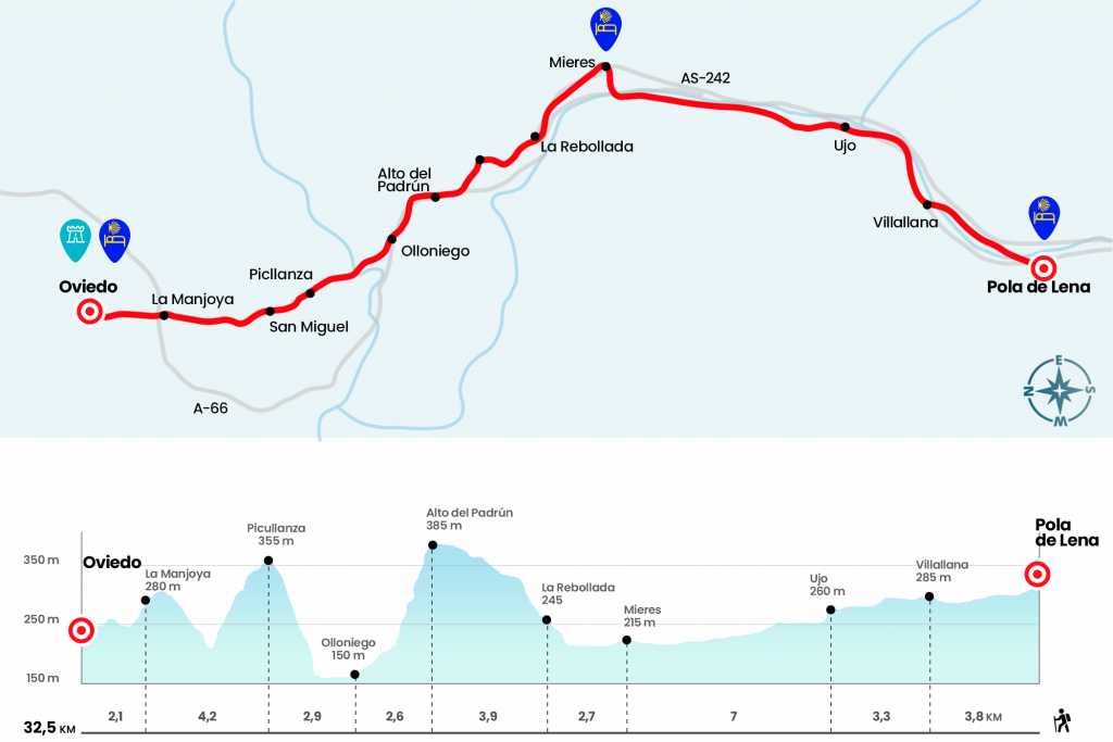
The route
- Km 0. Pola de Lena (All Services)
From the same hostel, we return on our steps through Ramón y Cajal and at 80 meters we turn left hand to descend the staircase of Fuentina. We arrive at Plaza Alfonso X El Sabio, which we cross to the street Corporaciones de Lena. Always in front connects with that of Hermanos Granda. Please note that later on we will have to turn right onto Celso Granda Street, guided by arrows and not by the cairn, which indicates from the front. Through Celso Granda we take a roundabout and cross the Lena River to take a paved runway that circulates next to the river, and that the neighbors, as on so many sides, know as the walk of cholesterol (km 1,1).
The walk progresses without loss between the river and the A-66. Before we reach the gas station of Villallana we will pass through a tunnel to our right to appear on the other side of the highway, we turn to the left on a path parallel to the fence of separation of the highway to pass the gas station, we go up a nice road to Castiello, we will reach the sign of Castiello, we will take the path that leads us to the stop of the boards We will enter Ujo through the bridge over the river Caudal at the height of the Geologists chalet.
- Km 7.1. Ujo(Stores. Bars. Office. ATM)
We see in an informative panel references to the Roman Way of La Carisa, today balized as G.R-100.1, that crosses the Cantabrian Cordillera from the south through the Carraceo Stand and the Ranero Sierra. The pilgrims' itinerary continues for more than an hour along the Caudal River to Mieres del Camino. We crossed the river bed by the pedestrian bridge of the Perra, apparently called for the toll that was charged to use it (Km 13).
We then saved the A-66 by a tunnel and the EFVE tracks by a walkway. We have access to Manuel Llaneza Street, where a large part of the commercial activity is concentrated, which we will walk in front in its entirety. At the bottom we turn left onto Teodoro Cuesta to reach the Plaza de la Pasera and its church in San Juan.
- Km 14.1. Mieres del Camino(All services)
At the foot is the Plaza de San Juan, better known as Plaza de Requexu. The sculpture of the scanker, by Manuel Félix Magdalena, presides over this space of traditional Asturian architecture that hosted livestock and grain markets, today overflowing with sidrerías. We continue along Calle de Oñón (AS-242), next to the coal laundry El Batán to the La Peña district.(km 15,6)
Later on we will continue through AS-242 direction El Padrún. It is a port with an affordable slope and very little traffic. After the Hotel Mesón La Peña we will reach La Rebollada, at the foot of the Gua peak. In this parish of Mieres we meet the church of Santa María Magdalena, of Romanesque foundation but demolished in 1921. It still retains half a hundred original chandeliers and an arc of the apse. He guarded the height of San Lázaro who presided over the old malatry, always located on the outskirts of the important population centres.
- Km 16.8. La Rebollada
Several neighborhoods of the parish of La Rebollada, such as Repitaneo, El Rollo, Copián, where there existed a pool, Saint Lucia and Aguilar. From the port we do not lose detail of the Caudal mining basin, with the thermal of La Pereda, the well San Nicolás, etc. We ended up crowning El Padrún at a height of 385 meters, entering in turn in the Council of Oviedo.
- Km 20.7. El Padrún (Bar-sidrería)
As soon as we chop the detour to the right towards Casares. In this immediate population we turn left at the height of the fountain and leave the track on the right 100 meters later, thus entering into a framed path. We will then end up with AS-242, whereby we will go down a bit. Later on we left the road towards La Estación, passing by the Baroque fountain of Los Llocos. We soon saved the tracks below and over the A-66 to return to the AS-242, which starts in two to Olloniego.
- Km 23.3. Olloniego(All services)
At the exit of Olloniego we pass by the tower and the palace of Operating Rooms. We will continue through the arcén of AS-242, crossing above the Nalón, a river that will cross again tomorrow or after those who continue on the Primitive Way. Behind the bridge of the highway of Castilla is the house that served as the toll office of the Real Portazgo, always present in the great communication routes. Next to it is a legume that indicates the distance to the capital: 1 ½ legumes. The Castilian language was established in the 16th century at 20,000 feet and would amount to 5,572 kilometers (Km 24,7).
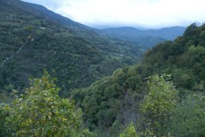
We left the road on the same curve, right after the Portazgo office, entering a path that ascends the mountain. Nothing led us to assume that this stage was going to give us this succulent stretch… and there will be more like this. After the first send, we went off to a neighborhood track, which we followed in front of us. We continue to climb and, at the latest, we take a path that advances parallel to the runway, where the path of an old road in some cobblestone section is extended. We finally arrived at the entrance of the Picullanza House, the Council of Ribera de Arriba
· Km 26.2. Picullanza
At the exit we get the first panorama of Oviedo, where the Palacio de Eventos y Congresos, work of Santiago Calatrava stands out. The cathedral is not yet visible. We started the descent, which leads through the sale of Air and San Miguel (Km 27,4) We are once again surprised by another beautiful wooded path by the streams of La Ceprosa and Morente. It ends up in another neighborhood runway that ascends the places of Caxigal (Km 29,2), Los Prietos, Los Barreros and El Caserón, population entities of the Ovetense parish of La Manjoya. Behind the ruins of the chapel of Santiago we already see the cathedral of San Salvador. Not in vain the toponym Manjoya derives from Monxoi (hence also Monte do Gozo), which in the words of historian Juan Uría “expresses the joy that the pilgrims experienced when they were close to the end of their journey”.
- Km 30.4. La Man₡- Ermita de Santiago
Next to the modern church of Santiago we went under the A-66, descending to the neighborhood of San Lázaro. About 350 meters after the walk under the highway we turn diagonally to the left by Malatería Street, next to the Winter Park, reaching Gil Blas Street. We continued on her right for 50 meters to twist left by Aurelio del Llano. We converge on Muñoz Degrain Street (Ronda Sur-N-630), which we cross in front of the pilgrim monument (Km 31,5).
As soon as we cross, we continue in front of Leopoldo Alas, after which we arrived at the gates of the historic centre. As in ancient times, we access it through Magdalena Street, where Uría details that “the pilgrims sometimes entered in tropel, carrying wax or sebum candles, accompanied by the reservoirs”. Under the arch of the City Hall we link in front of the streets Cimadevilla and La Rúa, thus ending in Plaza Alfonso II El Casto, presided by the Sancta Ovetensis.
The difficulties
Remarks
In images
What to see, what to do
The hostels

¿Do you want to send any photo of "The Camino de Santiago"?
If you have any photos of "El Camino de Santiago" that you want to share with us, you can send them to us and enlarge the photo gallery
Forum: What pilgrims think about the Camino de Santiago
See all