Article translated by an automatic translation system. Press here for further information.
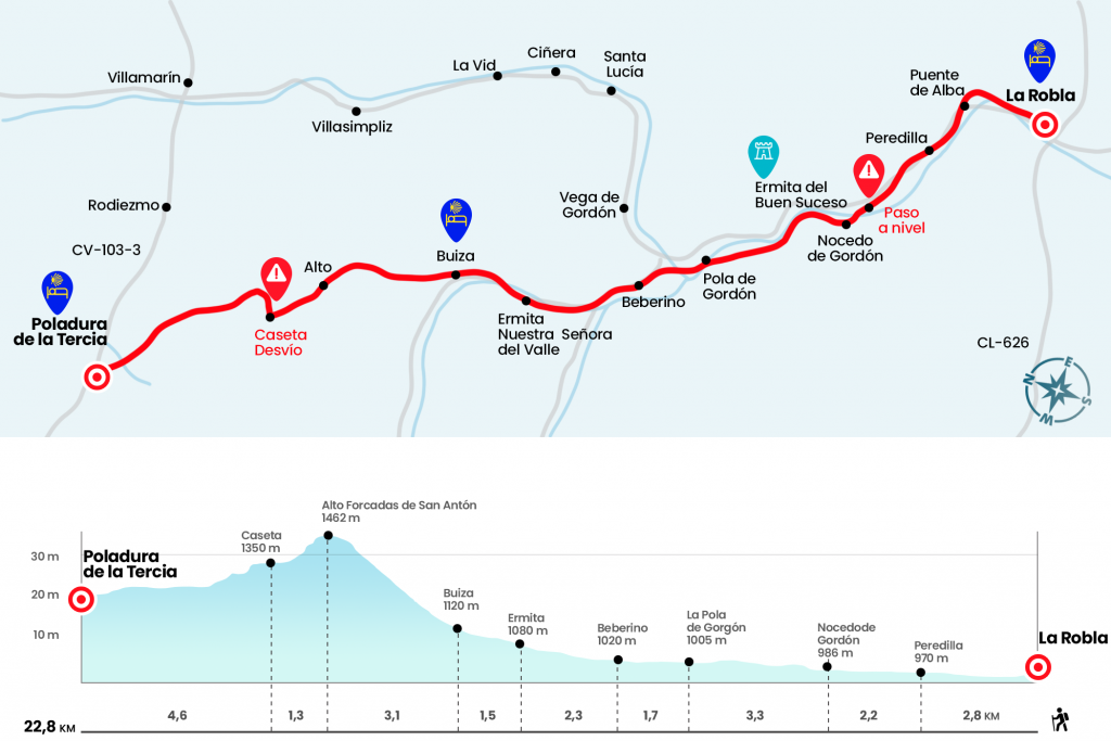
Stage of La Robla to Poladura de la Tercia
The first 14 kilometers prepare us for the ascent to the Forcades
Information about the stage 2: Stage of La Robla to Poladura de la Tercia
Enlarge map
The route
- Km 0. La Robla(All services)
We say goodbye to La Robla on Calle Mayor, which is one with the Sales of Alcedo, parallel to the course of the Bernesga. We soon reached the Encañao, as the aqueduct of 1795 is known. Not far away is the bridge, which gives way to Puente de Alba. In this La Robla pedanía we approach N-630 at p.k. height. 118, but we did not circulate through it.
- Km 1.7. Alba Bridge
The one we do take, on the right hand, is the former national, which passes over the roads and under the viaduct where the high-speed train will run. It brings us to Peredilla, already the town of Pola de Gordón, with an endless street Real.
- Km 2.8. Peredilla
At the end of the town, past the house named “La Serna”, we left Real Street on the left and saved the N-630 by a tunnel. An andadero of land and gravel parallel to the tracks of the train, with the stony silhouette left hand of the Fontañán peak of 1,629 meters, now progresses from front to the hermitage of the Good Event, built around 1766, as it says in the dintel of the door located at the head.
- Km 4.4. Hermitage of the Good Event(Bar-Restaurant)
The itinerary continues through the arcén of the N-630. We drove about 200 meters down the same national and we left to cross the level step! And then our beloved Bernesga. Without entering Nocedo de Gordón, next to the information panel referring to the “Trincheras de Gordón”, we took to the right the road La Barzanilla.
- Km 5. Nocedo de Gordón
After the viaduct, these border lands during the Civil War lead us along the dense tree-lined riverbank of sauces and alisos that accompanies each Bernesga nook. Thus, surrounded by green, the path advances to the south mouth of the Pajares tunnel, future AVE, we border the works on the right and continue on asphalted runway to La Pola de Gordon, a town to which we arrived after crossing the train tracks underneath and by a bridge the river Bernesga. As soon as you cross the bridge, the road rotates to the left, but you will have to enter the population if one of your services is required.
- Km 8.3. La Pola de Gordón(All services)
Caution: Anyone who goes overnight at the hostel in Buiza should buy here what they need, as Buiza lacks services! The same goes for those who are not going to book dinner (must be done in advance) in the rural house El Embrujo located in Poladura de la Tercia (659 030 282), as Poladura does not have services either!
As soon as we cross the river we turn left and we accompany the river a few meters along the Arenal Walk. We turn right through the Severo Ochoa crossing and we go to the street of the Constitution, the principal of Pola de Gordón. We followed her to the left, seeing the church of the Asuncion, built on an old pilgrim hospital, and we left the Puebla.
We left the access road to the N-630 on the left and we ended up descending to a metal bridge of the railroad, which we drew below. So we got to the industrial estate Valdespín and, just past Velasco Furniture, we turned left to go to the LE-473. On this road, after last crossing the Bernesga, we will arrive at Beberino.
- Km 10. Beberino
We crossed this small town by the same LE-473 and continued through it following the river Casares. Later we left this road where it is directed to Buiza and Brochures, which circulates next to the stream of Brochures (Km 11). It will take us to Buiza, not without passing by the chapel of Nuestra Señora del Valle, whose image arouses great devotion among the neighbors, who come in pilgrimage every August 15 (Km 12,3). Buiza Hostel, old school, is located at the entrance of the town on the right hand, next to the office and the sports courts. However, we must enter the village to seal and collect the keys.
- Km 13.8. Buiza(Hostel. Bar social-drinks only)
Already cited in 1036, this population, where the passage hardens and narrows towards the hills of San Antón, served as an inn to many farmers in their periplo by the canned montaraces and was over centuries the main route to Asturias.
(On the facade of the church of Buiza are indicated the two possible variants to continue our path, on the left the official route, which we describe in this guide, and on the right the variant by Villasimpliz. This variant is used in winter, and perhaps in spring and fall depending on the climatology, due to the impossibility and danger due to the snow of going through the official route).
We crossed Buiza through the central street La Iglesia and, without reaching the parish of Justo and Pastor, we turned left hand next to the source of rich and cold water, where it would be no more to fill the container facing the first mountain crossing. After the fountain we climbed right down the street of Las Sierras to leave behind the last houses. We must be careful and not stumble upon the wires arranged for livestock.
The first steps of ascent intimidate, because the mismatch is charged, so we gain height quickly. It attenuates as we advance, having a privileged view of Buiza and the collado of Villasimpliz, which rises to the right hand. Sheltered from oaks, brews and brooms, the path passes by a rock that resembles the profile of a face with a stuffy nose (16.1). Later, the stony trot crosses between the sharp rock formations known as the San Antón Forcades. However, there is still a bit of grassland until it reaches the highest level of the day. A 1477 story tells how in these sunny days there was a guest, where a man fed the pilgrims (Km 16,9).
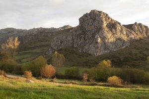
Along with the massive stone milestone, the runway descent has no doubts, crossing several spots of wild pines. At 1.3 km from the top, after a steep curve on the right hand, we found a caseta (Km 18.2). Beware!At this point we left the runway on the left, if we were to follow straight we would reach Rodiezmo and follow a narrow path that progresses over Rodiezmo's holes. From here we will begin to be guided by the reliable and necessary “lemon crutches”, the name with which we lovingly baptized the yellow stalk stakes crowned with the form of an vieira. Off the road is Rodiezmo, on the right hand in the valley and under the figure of El Fontún, 1,951 meters. Poladura is still within an hour of walking and we move forward between grasslands, following the steps of piruleta in piruleta and of cairn in mojón.
At some point we can find mud due to the presence of several streams, such as La Malena and El Ruelo. After the water tank of San Martin de la Tercia we descend to the stream of Lamoso, which we cross through a wooden bridge.He replaced the former Pontón de Romero here located and was finalized, not without great effort from José Antonio, Javi, Jesús and Luis, on 25 October 2012 (Km 22.2). Once in Poladura de la Tercia, the Camino passes by the hostel of the old schools of the town.
- Km 22.8. Poladura de la Tercia(Hostel. Country House)
The difficulties
Remarks
In images
The hostels

¿Do you want to send any photo of "The Camino de Santiago"?
If you have any photos of "El Camino de Santiago" that you want to share with us, you can send them to us and enlarge the photo gallery
Forum: What pilgrims think about the Camino de Santiago
See all