Article translated by an automatic translation system. Press here for further information.
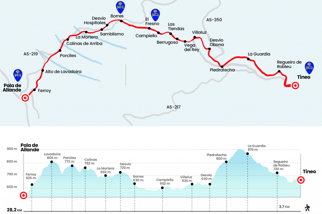
Stage from Tineo to Pola de Allande
Great opportunity to enjoy the Allande Council
Information about the stage 4: Stage from Tineo to Pola de Allande
Enlarge map
The route
- Km 0. Tineo (All services)
We leave the Mater Christi hostel and turn right through the Jesus Evaristo Casariego crossing to descend to the City Hall. Breakfast is possible in any of the bars around or in the hotel cafeteria, which open early. After the consistorial house we turn right by Calvo Sotelo, which becomes Avenida González Mayo. After 150 meters we climbed to the right by Venera de la Conda, which in turn ends in the street of the Fuente. We soon reach the fountain of San Juan, where there are a couple of tables and banks for rest. If we do not carry water in the container it is time to fill it, we will need it later. Soon the pavement is finished and, on the left hand, we take a road between deciduous ends to cross the Robleu Regueiro (Km 2.4).
We continue along the viewpoint of Letizia, where the last of the Philippines lives, in allusion to its owner Pana, neighbor of the Villa. On this tour of the Tinetense Sierra, which advances the skirt of Mount Brañugas (1.016 mt) and the Navariego peak, each step deserves a pause. The endless succession of lomas extends to the Leonese summits. At the forefront is also the Puerto del Palo, which we will take off tomorrow, and the first Galician foothills. Bathed in the light of dawn, the panorama is even more extraordinary. We went by a water tank (Km 3.5), following the steep ascent of the beautiful places of La Freita and Rebuchar to the collado of La Guardia (Km 5.4).
We took the paved track to the left and left it on the right after 150 meters. The herbose road surrounds the Puliares peak next to the wells of La Llamavieya and Ruxidor. We arrived at a concrete track that leads to the road of Cerezal and descend to AS-350 at the height of the Piedratecha farmhouse.
- Km 7.5. Piedratecha
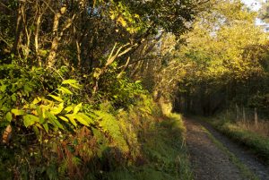
We followed the AS-350 for several minutes and left it by the left shoulder. The trail descends through a delightful deciduous forest and plants us along with the diversion that leads to the monastery of Santa María La Real de Obona. It is only 350 meters away and we recommend visiting it, although this Benedictine gem of the 13th century is even worse than that of Cornellana. Alfonso IX, the same who granted the Puebla Charter to Tineo in 1214, ordered by decree “that whoever walks to Santiago de Galicia do so by passing through his Puebla de Tineo and by his monastery of Obona” (Km 9.2). Back at the fork, we turn left and continue our path. Over the gloomy vaguada we have a fabulous view of the village of Obona, nestled on the middle slope. The runway finally flows into Villaluz, village of the parish of Obona.
- Km 11. Villaluz
We found a meadow and a fountain before going to the TI-3 road. Through this route we cross one to several villages of the parish of Obona, such as Vega del Rey (Km 11,8), Berrugoso and Las Tienda (Km 13) to finally reach Campiello, where we can make a well-deserved break in Casa Ricardo or Casa Herminia, which also has a hostel. Those who will make the primitive route of Hospitals will have to do night here or in Borres, population also provided with bar and hostel.
- Km 13.9. Campiello(Hostels. Bars. Shops)
We continued through the TI-3 passing through El Fresno, with its Magdalena chapel, and El Espín. We left TI-3 at p.k. 7, taking the place that heads to Pereda, Orrea and Sangoñedo. We left it on the right after 350 meters. A herbose path leads to Borres. We left the diversion from the hostel, located at the top under the road, and we reached the Barín de Borres, which opened in 2013 and where the keys of the hostel are collected (observations).
- Km 16.8. Borres(Hostels. Bar)
Pilgrims heading to Pola de Allande, a distance of 11.4 kilometers, can stay overnight or continue the day. After the Baron we climbed to AS-219 and crossed it in front to follow the ascent on a cement track. Fabulous landscape we left at the exit of Borres. Behind his roofs is already the passage, the metaphor of Machado’s great poem: “When you look back, you see the path you never have to tread again.” A forest track runs along the line of a pine tree and comes next to the diversion heading to Puerto del Palo along the primitive route of Hospitals, which we will describe below. (Between Borres and La Mortera, just before reaching Samblismo is the diversion to make the route of the hospitals, this route is 5 kilometers shorter than that of the Pola and with less slope as it rises directly, contrary to that of the La Pola that goes down and then go up the whole suddenly, it is well signalized, yellow arrows and wooden poles of this high road each little bit can If we choose this option that rises directly to the top of the Martha and then to the Palo we will have to follow the path that marks to the right, to the left we would go down to the Pola of Allande, it is necessary to carry with paradise and some food because in the route there are no services and the few fountains are many times dry, the way passes through the top of the town of La Mortera This route is inadvisable in winter by snow and you have to be careful the days of fog). This route from the town of Borres to the port of Palo is 15 kilometers.
Two hundred meters later there are the first houses of Samblismo, village of the parish of Borres.
- Km 18.7. Samblismo (hostel)
We crossed the AS-219 and fired Samblismo on a paved road that brings us closer to La Mortera, belonging to the parish of Santiago de Cerredo.
- Km 19.7. La Mortera
After the La Mortera River we took a herbose path that ascends to the road. The road/road dance will continue for the following kilometres and, after saving the AS-219 by a tunnel, we will go up to Hills of Upstairs, also from Santiago de Cerredo.
- Km 21.7. Top Hills
In a few hundred meters we left the AS-219 again, this time on the left, and we went down to the river Villaverde, which we crossed thanks to the bridge decorated with the inscription ‘2010. José Pérez Satorrio’. We climbed up to a paved runway that came back down the road. For it we easily crowned the high of Porciles, 773 meters high.
- Km 23. Porciles(Bars)
At the entrance of this parish we receive the Bar San Roque and almost to the exit of the town we find the Bar Casa Boto. As soon as the latter passes, we release AS-219 on the left and we go down abruptly to the Porciles River. After the course comes a hard stretch, where steps help to overcome the slope, which climbs back to the road. We overcome the small core of Lavadoira and crowned the top of the same name, located 806 meters.
- Km 25.2. Lavadoira
So far is the Council of Tineo. Just before we reach the sign announcing the entrance to Allande, we leave the road on the left shoulder and take a path down to Ferroy on the Crown Peak skirt.
- Km 27.2. Ferroy
We crossed the population and went to AS-217, which we left right away on the left. A nice shortcut to the edge of the Caleyo regueiro plants us at the entrance of Pola de Allande. We passed by Villa Rosario and then found the hostel of pilgrims.
- Km 28.2. Pola de Allande(All services)
The difficulties
Remarks
In images
What to see, what to do
The hostels

¿Do you want to send any photo of "The Camino de Santiago"?
If you have any photos of "El Camino de Santiago" that you want to share with us, you can send them to us and enlarge the photo gallery
Forum: What pilgrims think about the Camino de Santiago
See all