Article translated by an automatic translation system. Press here for further information.
Sala to Tineo Stage
The pilgrim can enjoy an idyllic forest of oak and chestnut trees
Information about the stage 3: Sala to Tineo Stage
Enlarge map
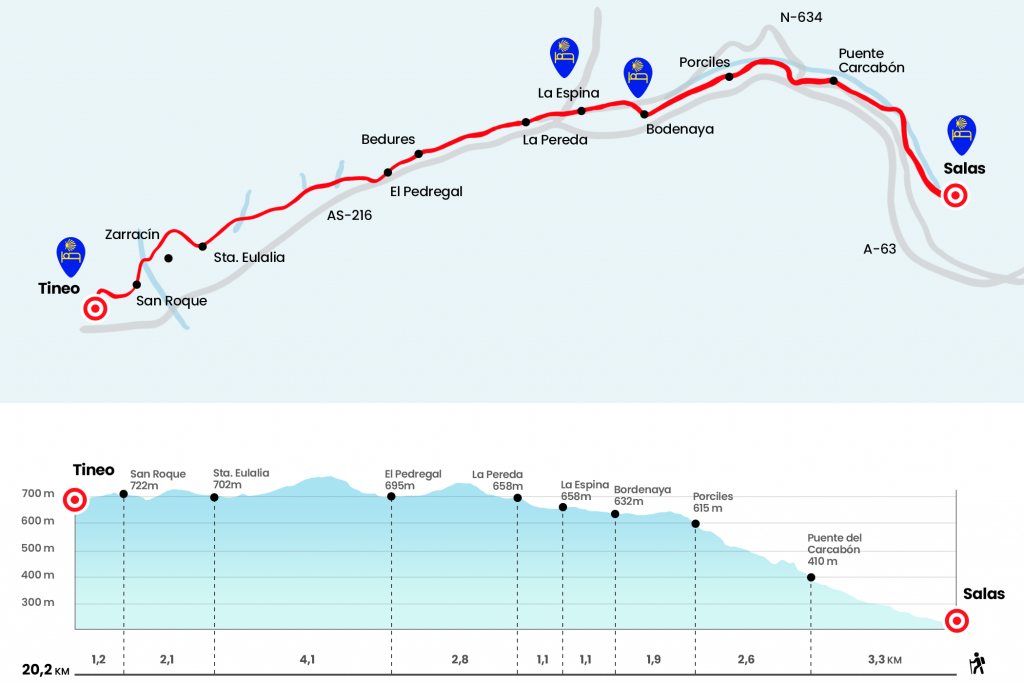
The route
- Km 0. Rooms (All services)
If we have stayed in the municipal hostel, we progress to the nearby Bridge Street to cross the river Nonaya and turn right onto the main avenue to the plaza de la Campa. In it we pass under the arc that connects the palace of Valdés Salas with the medieval tower. A few meters later we take Ondinas Street, which is born on the right hand and, among fruit trees, we enter a comforting sidewalk that walks along the Nonaya. We are gaining height for this photogenic section, crossing the bridge of Borra (Km 2.5) and then the bridge of Carcabón (Km 3.3).
After the latter pontoon comes a strong slope that plants us on the N-634. In this section of road we pass a few times under a viaduct of the highway and, at the latest, after passing a house, we left the road on the left to take a road. We continue to climb up and we culminate the climb along a track parallel to the highway. Thus we arrived at Porciles, village of the parish of Bodenaya.
- Km 5.9. Porciles (Hostel)
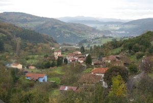
Just before reaching the plain, under a mountain covered by wind farms, let us not miss the opportunity to discover the birth of the Nonaya River, which we cross in Salas. We can cool our feet ( if time allows ) in an old laundry room next to the river's birth. There is the Posada de peregrinos Fontenonaya, recently opened by Nico, where you will find the true spirit of the Camino. We continue to the immediate Bodenaya. After the cruise and church of Santa Maria, we turn right to reach the pilgrim hostel that founded Álex, already a historical of the Primitive Path. In summer 2007 he established in this Asturian parish the most traditional Jacobean hospitality and since then the doors of his house are open to pilgrims. David Carricondo took the witness of Álex in early 2015 and since then many pilgrims are grateful for their welcome.
- Km 7.8. Bodenaya (Hostel)
We crossed the N-634 after the hostel and walked away from the population to reach La Espina shortly. After the tanatorium we go down to the road, where all the services are located. In May 2016 they inaugurated here a rest area for pilgrims called The Pilgrim's Stop, with vending machines, snacks, parafarmacy, etc. (see section observations). Juan Uría states in Las Peregrinaciones a Santiago de Compostela that "in La Espina there were at least two hospitals". One under the patronage of San Pedro and the other dependent on the Compostelan mitre. Also according to Uría, from La Espina began two different itineraries: the one we followed towards Tineo and Pola de Allande and the other that led towards the coast to join the Camino del Norte.
- Km 8.9. La Espina (Hostels. Rest area for pilgrims. Bars. Shops. Pharmacy. ATM)
The route passes next to the El Cruces hostel, which was run by Carmen and opened in June 2013. By leaving La Espina, on the roundabout, we take on the right a path that advances along a stone mute. From this point on, for much of the year, clay begins to take on prominence. We reach in a hallowed La Pereda, the most oriental parish of the council of Tineo, where is the chapel of the Christ of the Afflicted .
- Km 10. La Pereda
We turn right next to the temple and climb to the fountain of the Reconco, located in the neighborhood of the same name. At the middle slope the views of the plain are unmatched. The road leads to several villages or neighborhoods belonging to the parish of La Pereda, such as El Espín, Bedures (Km 12,2) , where in a vaguada we see the most photographed mill of the Primitive Way, and La Millariega, whose core sits beneath our feet. In five minutes we enter El Pedregal, where we receive an imaginary guard dog conveniently tied.
- Km 12.8. El Pedregal
The route goes down to AS-216, where the bar was closed at the end of 2013. At the exit of this Tinean parish, after passing p.k 4, we left the road on the right next to a cruise. At 100 meters we turn left, determined to face the mud again, this time magnified with a good dose of water included. This section of almost 4 kilometers to Santa Eulalia, with hardly any references, sits under the Sierra de Tineo, overlooking the left hand of the Sierra de La Curiscada and the polygon of the same name.
- Km 16.9. Santa Eulalia
Without accessing this parish, just before we reach the cemetery, we turn right. We climb a bit, leaving the village of Zarracín to the left, and we cross the river Ferroiro. As half a kilometer we pass by the first houses of San Roque (Km 19) and then we surround the football field to reach the Campo de San Roque, where the hermitage of this holy walk is located. This esplanade is celebrated in mid-August the big day of San Roque, which includes a popular meal and a bowling championship. We continue along the promenade of the Friars and, just before reaching the statue of the pilgrim, raised in 2004 and where on the solar clock you can read: "viator horam aspice et abi viam tuam" (walking, check the time and continue your journey). We turn left to descend to the pilgrim hostel. Mater Christi was baptized in memory of the former hospital in Tineo, in which pilgrims worshipped Santa Ana.
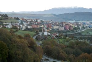
- Km 20,2. Tineo (All services)
The difficulties
Remarks
In images
What to see, what to do
The hostels

¿Do you want to send any photo of "The Camino de Santiago"?
If you have any photos of "El Camino de Santiago" that you want to share with us, you can send them to us and enlarge the photo gallery
Forum: What pilgrims think about the Camino de Santiago
See all