Article translated by an automatic translation system. Press here for further information.
Stage from Tui to O Porriño
Tour of 119 kilometers that can be performed comfortably in 5-6 days
Information about the stage 1: Stage from Tui to O Porriño
Enlarge map
Points of interest in the stage 1: Stage from Tui to O Porriño
The route
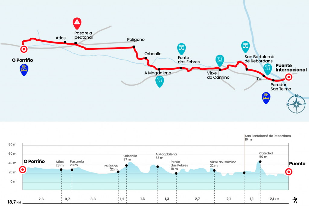
- Km 0. International Bridge
The Portuguese Way leaves Valença and enters Spain through the International Bridge over the Miño River, opened in March 1886 and influenced by the designs of French Gustave Eiffel. The lateral walkway is an excellent viewpoint of the city of Tui, heir of one of the mansians of the 19th Roman Way that united Braga with Lugo and Astorga. The first steps take us next to the Police and Customs Cooperation Centre to continue in front of the avenues of Portugal and Galicia. Before arriving at a gas station, at the height of the junction towards the A-55 and the PO-552, we turn right to the Parador de Turismo San Telmo, faithful recreation of a Galician pazo with included cruise (Km 0.8).
After this we arrived next to a stone milestone of the Camino de Santiago Portuguese that marks 115,454 kilometers to Santiago de Compostela. On the left, the Barca road gives us an extra-urban panorama of the historical nucleus and the cathedral, at the top. We approach it by the streets Bishop Maceira, Arrabal de Freanxo and already ascending by Baixada or Arrabal de Freanxo and rustic Piñeiro, where we turn ninety degrees to the left to undertake the last effort for the rustic Sanz. After the building popularly known as Old Jail, with a gate of 1584, we arrived to the cathedral of Santa Maria, temple – horseback fortress between the Romanesque and the first Gothic on the Iberian Peninsula and consecrated in 1225.
- Km 2.1. Tui(All services)
The urban circuit immediately visits the old hospital for the poor and pilgrims, from 1756, today converted to Diocesan Museum. The public hostel, and the chapel of San Telmo, are a few meters below, on the right hand. We continue next to the City Hall and walk to the church – convent of the Clarisas, which we surround by the rustic das Monxas. After the vault passage we turned left by Canella Tide and went down to the rustic Tide, where the Bergán gate was, one of the entrances of the Tudense wall. Eighty meters later we turn left onto the rustic Antero Rubín, which brings us closer to the Gothic church of Santo Domingo, with two good Baroque altarpieces from the 18th century. We passed an arch, today elevated step, and later, after a slight curve, we took the street on the right.Notice the diversion!Drive to the parish of San Bartolomé de Rebordans, recognizable by its imposing sixteenth cruise. Next to the cruise, the highly transformed Romanesque temple of San Bartolomé de Rebordans rises. They deserve the original capitals that tell scenes like Herod's dinner.
- Km 3.2. San Bartolomé de Rebordans
We leave the church on the left to take a path that passes by a utility room and a sink. A small corner of nature decorated by the Galician minifundio gives way to a paved runway and the Ponte da Veiga on the Louro River. It's medieval in origin and it's on our right. We resumed the march on another dirt road, apparently coinciding with the route of the Roman Way XIX, to take later a road that passes by the lighthouse of Rebordans and reaches the N-550, route that connects A Coruña with Tui and that will follow us very closely to Santiago. We cross the road to enter the Virxe do Camiño, linked to the parish of Rebordans. About 80 meters after crossing we must turn right to meet the chapel of the Virxe do Camiño.
- Km 5.3. Virxe do Camiño
Then starts a stretch of a couple of kilometers through the right wing of the road PO-342. It is spacious and covered with a comfortable tread material. As soon as we start, we go over the A-55, the Atlantic Highway, and about a kilometer and a half later under the AP-9. At the height of the Paredes crossing, about 250 meters after the passage under the highway, you have to pay attention and leave the road on the right. On the AP-9 and on a forest track we will reach the Ponte das Febres on the San Simón creek. It is covered by a walkway and received this name because in this place San Telmo died in the spring of 1251. Pedro González Telmo, which was called, is the skipper of sailors (Km 8). For this gloomy pleasant setting, covered by the vegetation on the banks of the Louro River, we reached A Magdalena, from the Tudense parish of Santa Comba de Ribadelouro.
- A Magdalena(Bar.)
We traverse the site following the directions and cross a road to go forward. At the exit of the population we come across a calvary formed by five cruises and turn right, on the Cairn 106,888, to cross an attractive bridge of large slabs over the Louro (Km 10). Another nice section – always following the widest path – leads us to Orbenlle, belonging to the parish of San Salvador de Budiño, and the Concello de O Porriño.
- Km 10.9. Orbenlle(Bars)
- alternative itinerary to avoid industrial polygon, fully recommended (500 meters longer):
In the vicinity of Orbenlle lies the alternative route that prevents the passage of the industrial estate since September 2013. The summary of this description is based on the work of the AGACS on this road, which is the work of José Antonio de la Riera, Manuel Garrido, Luis Freixo and Manuel G. Vicente:
The alternative starts 300 meters after p.k 106.048 to Santiago. It's a left hand post, next to the poster. This variant descends slightly between tupid vegetation until the driveway of A Ponte Baranco, over the Louro, and then crosses a winter pass. From this point, a dirt road between vineyards and trees reaches a paved runway, which inhabits the parish of San Xurxo de Mosende, visiting the places of Monte, Vides and Cruceiro. Another later winter pass, known by the neighbors as the ‘Botate pass’, leads to a stubborn path. Then, a local court enters the parish of Santiago de Pontellas next to the houses of Centeáns. Here, a ‘cross of bites’ gives way to a magnificent cruise, located on the old Camino Real to Vigo. In this variant there are still more surprises, such as the chapel of San Carpio and its cruise, as well as the Quinta do Adro or da Inquisición, where the route is separated from the Camino Real. A local road with pedestrian rail and for cyclists leads from this point to the path that follows the trail of the Louro river (do not cross the river even if you see arrows, always progress with the flow to the right!) and that reaches the same hostel of pilgrims of O Porriño (Km 19.2).
- Itinerary through the polygon:
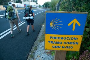
We cross Orbenlle by paved runway to the rest area managed by the Cultural Association A Lagoa (Bar). The scenario makes it completely from here as the industrial polygon As Gándaras stands, which, defiantly, awaits us down. We cross it through a cansine and infinite line about three kilometers to say goodbye next to a labyrinthine catwalk that saves the tracks of the train and leads us to the foot of the N-550 (Km 15,4).
Along the road there are several bars, cafes and service companies. We are in the parish of Atios, and if the line of the polygon was long and boring it is no less the one that comes next. We surpassed it and left the N-550 on the left, next to the Mojón 99.408 km, to enter O Porriño by the rustic Manuel Rodríguez. In a few meters we take to the right the rustic San Sebastian, where the hermitage of the same name is located, and later we pass by the side of the chapel of San Benito. When we go out to the rua Fernández Areal we see the apses of the church of Santa Maria and access to the rua Ramón González and the City Hall, a capricious work of the Porrian architect Antonio Palacios started in 1921. After the City Hall there is a roundabout. If we continue towards Mos and Redondela we continue in front; if we finish the stage here we turn left onto Buenos Aires Avenue. We save the step at level and in front of the Louro River is the pilgrimage hostel.
- Km 18.7. O Porriño(All services)
The difficulties
Remarks
In images
What to see, what to do
The hostels

¿Do you want to send any photo of "The Camino de Santiago"?
If you have any photos of "El Camino de Santiago" that you want to share with us, you can send them to us and enlarge the photo gallery
Forum: What pilgrims think about the Camino de Santiago
See all