Article translated by an automatic translation system. Press here for further information.
Round Trip to Pontevedra
After an appreciation of the Vigo estuary, we entered the Concello de Soutomaior
Information about the stage 3: Round Trip to Pontevedra
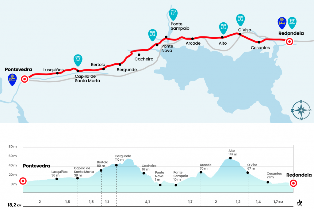
Enlarge map
Points of interest in the stage 3: Round Trip to Pontevedra
The route
- Km 0. Roundabout(All services)
Next to the facade of the pilgrim’s hostel is born the Angolan Rural of Queimaliños, which we continue from the front leaving the praza da Alhóndiga on the right hand. Without change of direction we link to the ruas do Cruceiro, Loureiro and da Picota and pass under one of the arches of the viaduct of Pontevedra, premiered in 1884 and still daily witness of the trains circulating between Vigo and Pontevedra. We go down to the meeting of the N-550, road that we cross by the baroque facade of the chapel of Santa Mariña (Km 0.7).
Through the Football Field pitch, in parallel to the N-550, we passed the municipal playing ground and left Redondela behind the timber factory to enter the parish of Cesantes. After the first street, in a slight climb, we turn right onto the Zacande stretch (Km 1.7). In the next bifurcation we continue on the right, it is the rustic Torre de Calle, which receives us with a nice ramp and a raised step that saves the train tracks, after which we turn left by the Camiño Real de Cesantes. This nice, but brief road leads to the Abreavella Nightmare, which we took to the left to meet the N-550.
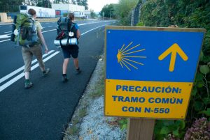
- Km 3.1. No. N-550(Hostels. Bar)
The intersection with the national, with plenty of traffic, is a black spot! That would have to be solved. After the crossing we enter the parish of O Viso, specifically the place of Tuimil. Attention should be paid to a left-hand detour, which has a hill that reaches a stone fountain and a playground, good place to take oxygen and soothe the dry (Km 3,7).
The slope is disinflated on a posterior dirt track that is born to the left and comforted by the company of pines and eucalyptus that fight for space. We reached the first stop of the day next to the ruins of an old house of postas, a place for rest, provision and change of mounts (Km 4.3). Three hundred meters later we get a panoramic view of the end of the Ría de Vigo, dotted with houses that are discovered by the hillside of the mountain. Below we go to the N-550 (if we go back for it 250 meters because we reach the hostel O Recuncho do Peregrino temporarily closed, call before to confirm availability) and cross it again to advance through the arcén until the entrance of Arcade, parish of the Concello de Soutomaior.
- Km 6.3. Arcade(Hostel. Bars. Accommodation. Shops. Health Center. Pharmacy. ATM)
The urban route passes next to a hornacine decorated with the motifs of the Camino de Santiago and full of all kinds of prints and dedication. The lavender fonte brings us back to the national road, which we cross again to continue through the rustic Lameiriñas. On our Arcade route we will not see the church of Santiago nor, as it is several kilometers away, the famous castle of Soutomaior. After crossing the street of Rosalía de Castro we will have the opportunity to stop at a bar or buy at any store, although we can also do it in the next locality.
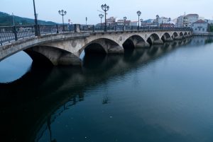
We go down to Ponte Sampaio, a colossal, angled tajamar stone that saves the river Verdugo, which after a 41 kilometer trip flows right here. This bridge was fought during the War of Independence a battle that ultimately led to the withdrawal of the French from Galicia.
- Km 8. Ponte Sampaio(Bar and shop next to church)
On the other side of the bridge is the population, already linked to the Municipality of Pontevedra. The itinerary leaves the road on the left to street and does not visit the parish church of Santa Maria, original of the 12th century, but very distorted by the reforms carried out in the 18th and 20th centuries. Services are also left aside, later on at the edge of the road. Next to a hórreo we turn right, we go next to the Bellavista pazo and after a cruise we fold left. After one more turn we left Ponte Sampaio in climb and in search of the site where the Ponte Nova was located, a medieval bridge of an arch that was shattered in 2006 by a river Ulló. The Portuguese Way was diverted and in October 2010 a new bridge was opened, although now of steel cutting and concrete. After the Ponte Nova el Camino you enter the Brea Vella da Canicouva, an evocative road of large slabs that runs through the itinerary of the Roman Route XIX (Km 9,6).
Cyclists will find it very difficult to stay on the bike and will have to get ground. The climb through the Brea Vella alternates sections of irregular stones with others of dirt and gravel. Before the climb is over, we reach a paved runway and we follow it on the right. Another couple of turns, one of them next to the cairn of the 72,061 kilometers to Santiago, which frees us from the road. In this way, we enter the parish of Figueirido, of the Concello de Vilaboa, on a track between Robles and later asphalted. The first family members correspond to the place of Bergunde (Km 12,1). Later we passed next to a fountain with the inscription Figueirido mountains and immediately through the places of Boullosa and Alcouce.
We continue the descent until we reach the EP-0002, a road that crosses the parish of Santa Comba de Bértola (Km 13,2) and that gives way to a short section of eucalyptus, chestnut and oak. After him, especially in spring and summer months, he has usually opened a kiosk. Then we will cross another road and by a dirt track next to a few maizales we will reach the chapel of Santa Marta, which dates from 1617 (km 14,7).
From this point on, in the place of O Pobo we will meet two stones of the Xunta, on the right will take us through the arcen of the highway EP-0002 to Pontevedra and on the left we will go through the nice river promenade of Rio dos Gafos, the two roads are joined to the entrance of the city, being the last one carried by our most recommended part because it takes us from the road and we are saved.
- Km 18.2. Pontevedra(All services)
The difficulties
Remarks
In images
What to see, what to do
The hostels

¿Do you want to send any photo of "The Camino de Santiago"?
If you have any photos of "El Camino de Santiago" that you want to share with us, you can send them to us and enlarge the photo gallery
Forum: What pilgrims think about the Camino de Santiago
See all