Article translated by an automatic translation system. Press here for further information.
Stage from O Porriño to Redondela
Beware! Gap between the hostel of Mos and the chapel of Santiaguiño
Information about the stage 2: Stage from O Porriño to Redondela
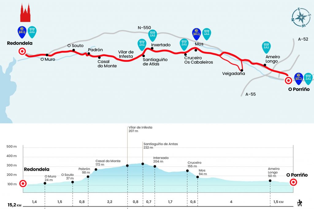
Enlarge map
Points of interest in the stage 2: Stage from O Porriño to Redondela
The route
- Km 0. O Porriño (All services)
We go back from the hostel, crossing the level step, to the roundabout of Plaza Central. Here we turn left onto Ramiranes Street to the roundabout of the N-550, which separates Concello de O Porriño from Mos. From the front we pass under the A-52, the highway of the Rías Bajas that comes from Benavente, and we enter Ameiro Longo, place of the parish of Sanguiñeda and Concello de Mos.
- Km 1,5. Ameiro Longo
We pass the fonte do Chan and a plaque tribute to the Novas brothers, renowned Galician mountaineers who have crowned a good number of ochomiles. After the marquesina we turned to meet the N-550. According to the new official delimitation, at this point we must cross the national road and continue in front of a few naves by the Chiringosta shirt in the direction of Piñeiro, where we will pass under the tracks of the train. We move along a local road that saves a river and we plant a little later at a crossing a T, which we follow on the right. Let us go this way by local road to Veigadaña, which has pilgrim hostel since March 2015.
The next significant milestone of the stage is the main nucleus of Mos, represented by the Baroque church of Santa Eulalia, the 17th century pazo and the pilgrim hostel. Next to the church there is a bar-restaurant (closed on Mondays) and in front of the hostel is the shop that provides Flora.
- Km 5.5. Mos (Hostel. Bar. Store)
At this point we began a demanding ramp up to the polychrome cruise of Os Cabaleiros of the 18th century and equipped with two lanterns (Km 6.1). By local road we pass the scattered nuclei of Os Cabaleiros and A Pereira, where a dirt track between oak, pine and eucalyptus makes us feel so asphalt but to which we return shortly in the place of Inxertado (Km 7,8). Above, we have stopped by a trocha that returns to the road at the height of the chapel of Santiaguiño de Antas, renovated in 2003 and situated at the highest point of the day.
- Km 8.5. Chapel of Santiaguiño de Antas (Bar)
As we cross the road we enter the Concello de Redondela and at 100 meters we stumbled upon the miliary of Vilar-Guizán-Louredo, an indicator of Roman distance from the 19th Way that linked Braga with Astorga. Then we enter Vilar de Infesta, formed as all the Galician parishes by a large number of scattered places that disorient us, as it is difficult to know with certainty where this or that place begins or ends. The parish is traversed slightly down the central road and attention needs to be paid to take a deviation to the left that passes by the churrasquería Choles (Km 10.2).
In front of the restaurant the itinerary folds right by a dirt track leading to another asphalt. Among pines we take a path to access the domains of the parish of Saxamonde. First the district of Casal do Monte and a little further down the district of Padrón (Km 11.5), which since October 2016 has the hostel O Corisco. We plucked into O Souto (Km 12.3) and easily reached the N-550 on O Muro.
- Km 13.8. O Muro (Bar)
We walked about 600 meters by the National and left it by the right wing to enter Rounddela. We immediately find the first relevant building: the monastery of Vilavella, residence of nuns in the 16th century and venue of events, weddings and baptisms today. After the convent we went under the viaduct Pedro Florani, inaugurated in 1876 and catalogued Good of Cultural Interest and we traveled the rustic Pai Crespo to cross Xoán Manuel Pereira (highway PO-250) and reach the hostel of pilgrims. It was enabled in the Casa da Torre, a 16th-century Renaissance stately residence inhabited by the Prego de Montaos family.
- Km 15.2. Roundabout (All services)
The difficulties
Remarks
In images
What to see, what to do
The hostels

¿Do you want to send any photo of "The Camino de Santiago"?
If you have any photos of "El Camino de Santiago" that you want to share with us, you can send them to us and enlarge the photo gallery
Forum: What pilgrims think about the Camino de Santiago
See all