Article translated by an automatic translation system. Press here for further information.
Stage from Pobeña to Castro Urdiales
We say goodbye to the Basque Country and hello to Cantabria by Castro Urdiales
Information about the stage 10: Stage from Pobeña to Castro Urdiales
Enlarge map
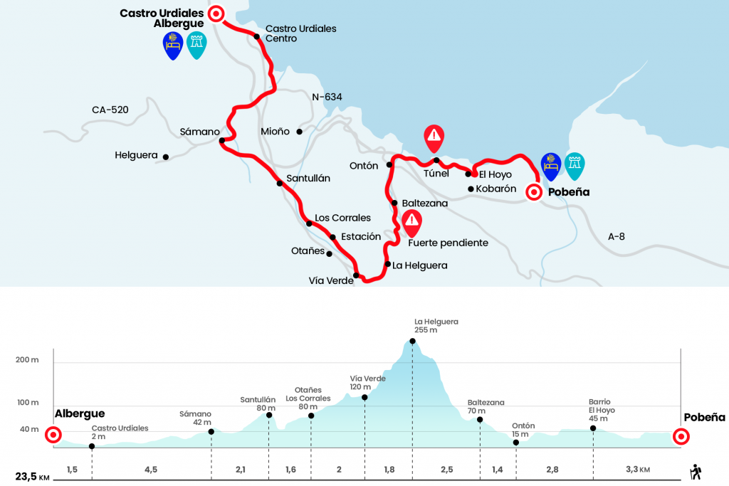
The route
- Km 0. Pobeña(Hostel in season. Apartamentos Rurales. Bar)
We returned to the stairs we left yesterday at the entrance to Pobeña. About one hundred steps, or more, go up to the route of the old mining railway, today Paseo de Itsaslur and Camino de Santiago, which drove the iron to the loadhouse located in La Arena and then departed to Europe, mainly to Britain. The nebulous days can still recreate the atmosphere of such activity and bring back the stress echoes and the squeezing of wagons. The wood fence protects us from the cliff and, above us, ferns, panties and scattered eucalyptus tapizan La Barra. An early bifurcation sends the bicigrines to the left (due to a posterior staircase) and the walkers to the right. Upon reaching a merchant, the coastline spreads and we can already see the village of Castro Urdiales. Then we will go along with several informative panels about the extraction of algae and the geology of the place.We pass a
parking lot and we arrive at a track that we follow right to El Hoyo. Surrounded by black elk, the neighborhood is left by the Camino (Km 3.3).
About 650 meters later we enter Cantabria, which will welcome us next week. In this province the official signs are scarcer and we will have to pay particular attention to the arrows, which at some points also shine through their absence. We soon went through the pointed Piquillo tunnel and continued until the tremendous viaduct of the A-8. After him we took the path that descends to our right. As soon as we cross the river Sabiote we turn left to enter Onton, town of Castro Urdiales municipality.
- Km 6.1. Onton(Pilgrim Hostel)
We visited the main nucleus, (up on the road is the pilgrim hostel "your way") and finally we climbed up some stairs to the N-634, at the height of p.k 138. At this point we have to choose between continuing through the arcén of the N-634 until Saltacaballo and Mioño, where it is possible to take a path that will bring us closer to Castro Urdiales, or taking the official Camino de Santiago that is headed by the CA-523 towards Baltezana and Otañes. The choice for the N-634 is much shorter, 10 kilometers to the hostel of Castro Urdiales versus the 17.2 kilometers of the official route, which we described in the guide.
We go up the CA-523, which saves the River Sabiote, and a few meters away we leave the asphalt on the right to approach us to the first houses of Baltezana. The route passes next to the urbanization El Manzanal and takes the road back to an orange house.
- Km 7.5. Baltezana(Bars)
We have a couple of bars, the second one, after the marquesina, closes on Monday. Before we leave the population we leave the road on the right and go down to the river, where a runway leads us back to the CA-523, which we follow on the right, ascending. Once the first curve was fixed, we entered a path between eucalyptus born in the left arches. It saves a bit of road at the expense of punishing us with a considerable ramp. Bicigrines are recommended to continue on the road! Fatigued, we went back to the road to top the port of La Helguera.
- Km 10. Alto de La Helguera
From the high we go down the road, which follows slightly to the right, towards the valley of Otañes or the river Mioño. Territory of the prerogatives Autrigones and which, as much of this Cantabrian cornice, went hand in hand through the kingdoms of Asturias, Navarra and Castile. We left the asphalt two kilometers later to catch the Vía Verde de Castro Traslaviña (Km 11,8). On our left, next to the Mioño River, Otañes is spread in multiple neighborhoods. Integrated in the municipality of Castro Urdiales, apart from its prized tower of the middle of the 15th century, it is worth noting that in this term a Roman miliary of the 1st century of the road linking Castro Urdiales (Flaviobriga) with the palentine Herrera de Pisuerga (Pisoraca) was found. After a rest area we went by the station of Otañes and later by the neighborhood of Corrales.
- Km 13.8. Barrio de Los Corrales
The panorama on our left stops at the peak La Cruz and the rock limestone of Santullán, naked and carving by the quarry. The Via Verde continues until the entrance to Santullán, where we turn left to climb to the CA-250 and the church of San Julián. At the foot of the road there are a couple of bars and a bakery.
- Km 15.4. Shrines(Bars, bakery, pilgrims' hostel)
We crossed the road and continued to arrive at the temple on a parallel street. It briefly departs to the CA-522 in order to connect to a paved runway that runs a short distance from the A-8. Attention must be paid because in one of the bifurcations we turn left until we cross the Suma river . The itinerary then goes up to Sámano, where The Jacobean Pilgrimages of Luciano Huidobro mention that there was already an important pilgrimage hospital in 1714. We follow the road to the right to the church of St. Nicholas – here is also a bar – and after boring the apse we continue to the right according to an official sign.
- Km 17.5. Takeout(Bar)
Then we entered the Llantada neighborhood and after crossing the water course again we turned 90 degrees to the left crossing the rest of the urbanization, which have changed the physiognomy of all these populations. We got to a bigger road, the CA-520, and we followed it on the right until the entrance of Castro Urdiales. After passing under the A-8 several roundabouts come and we take Paraiso Street to a gas station, after which we turn left towards the Urban Center and the Beach. There is a shortage of signalling here! You have to cross the Brazomar River and continue straight on the Ocharan Mazas promenade, under no circumstances follow the course.
The walk ends in another parallel to the beach, where we will follow the orange marks. Without loss we advance from the front to the marina and fishing, next to the maritime postcard formed by the formidable church of Santa María de la Asunción, with air of cathedral and the most important Gothic exponent of Cantabria; the medieval castle where the lighthouse and the hermitage of Santa Ana, founded on the rock and linked to the castle by the Old Bridge, gothic of a single arch.
- Km 22. Castro Urdiales – Centro(All services)
The hostel is about twenty minutes away. From the port you have to turn left to take Santander Street and continue forward by Silvestre Ochoa, which will take us to the bullring. On the street Ascent to Campijo, next to the coso, is the hostel of pilgrims (Km 23.5) .
- Km 23,5. Castro Urdiales – Hostel
The difficulties
Remarks
In images
What to see, what to do
The hostels

¿Do you want to send any photo of "The Camino de Santiago"?
If you have any photos of "El Camino de Santiago" that you want to share with us, you can send them to us and enlarge the photo gallery

Forum: What pilgrims think about the Camino de Santiago
See all