Article translated by an automatic translation system. Press here for further information.
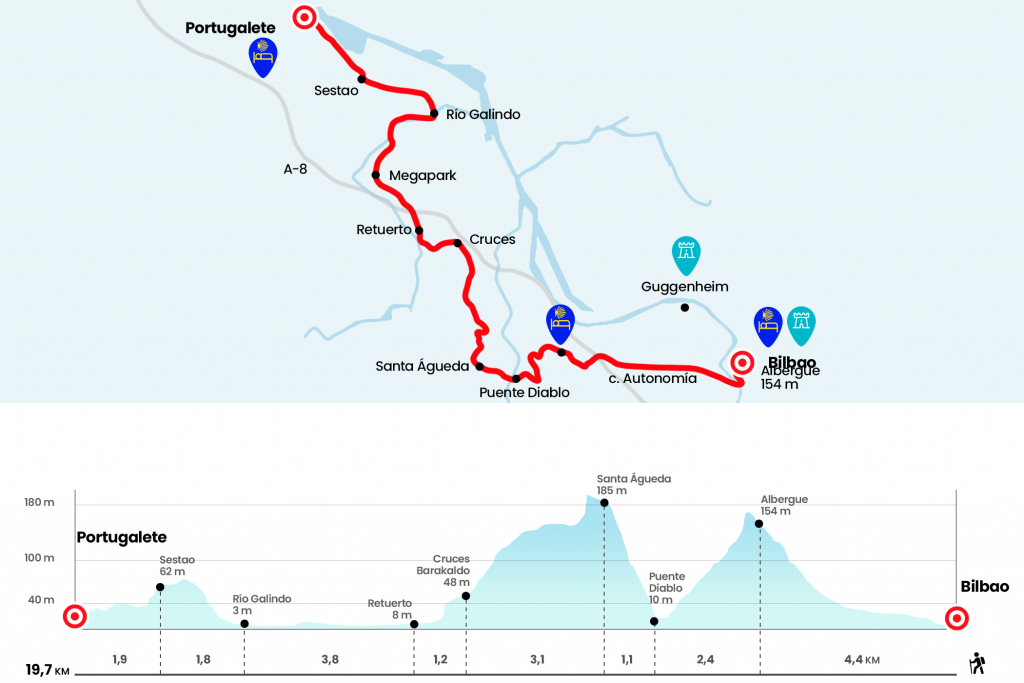
Stage from Bilbao to Portugalete
Elevation of 180 meters to overcome in the climb to Kobetas and the hermitage
Information about the stage 8: Stage from Bilbao to Portugalete
Enlarge map
The route
- Km 0. Bilbao (All services)
La Tendería, which is part of the seven primitive streets of Bilbao, flows into the street of the Ribera, which we follow on the left hand. Here is the large covered market of La Florida. At 120 meters we left the street on the right to cross the estuary of the Nervión or Ibaizabal by the bridge of San Antón. It illustrates the municipal shield and replaced the medieval bridge that for many centuries was the only driveway over the river. On Wikipedia, we can read that "in the 15th century under this bridge, criminals were impoverished", which was nothing more than tying a stone to the pot and throwing it into the water. After the bridge we turn right onto Bilbao la Vieja street, which connects in front of San Francisco Street. We went out to Plaza Zabalburu and took the endless street Autonomy for 1.3 kilometers. Without changing the address we will link to Montevideo Avenue (Km 2.7) .
We passed by the Basurto Health Center and soon turned left to climb a nice bit down Lezeaga Street. The itinerary later takes advantage of a pedestrian path that zigzaguea until reaching the Kobetas Road, where we have another privileged view of the city. In this natural viewpoint of Mount Kobetas, where the neighborhood of Altamira is located, is the hostel of pilgrims.
- Km 4.4. Hostel of pilgrims of Bilbao
Next to the Marquesina del Bilbobus we turn left hand to descend the other side down a stony path. Perhaps we are alarmed by the smoke from the Profusa factory, which produces coke for foundry, which brings in check the neighbors of the Delicias neighborhood. During the downhill you have to pay attention to a turn left to take a curve. Later on we passed a portillo and continued to the road, through which we descended. After a tunnel we reached the Bizkorta Layer, next to the Basurto-Castrexana road. We take the march to the left and take the crossing to Las Delicias, where we pass the river Kadagua through the bridge of the Diablo (Km 6,8).
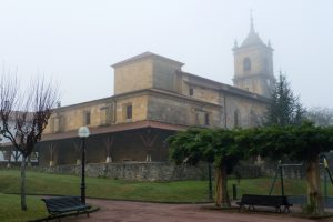
We enter the Deliun-Urgozo district of the municipality of Barakaldo, about 50 meters after crossing the bridge we find a wooden sign that indicates us way to Balmaseda (forgotten road) or to the north road, ours. Once we cross the tracks we climb the paved runway that heads to Santa Águeda. After several high-inclination curves we left the trail on the left and entered the medieval road under the mixed forest of Larrazabal. Along this road, which was Camino Real, the merchants went down to Castilla, via Balmaseda through the valley of Mena to Burgos, the products arrived from Europe and raised cereal and wool to embark on the continent. The road gives way again to the track, which now exhibits ramps that seem to be moved from the Angliru and the Cuitu Nigru and reach the hermitage of Santa Águeda, where there is a fountain and suitable space to make the first stop (Km 7,9) . We resumed the journey through the paved runway that ended up descending to the Baracaldic district of Cruces, where its emblematic hospital stands out.
- Km 11. Cruces (Barakaldo) (All services)
Attention, because in the inlet roundabout you have to turn left by the street of La Paz, towards the football field. We line it and go down to the bidegorri (bike path with paved path for pedestrians) that runs along the Castaños river. After a tunnel we turn right to continue along Ametzaga de Retuerto Street , also the Baracaldic district. We saved the N-634 for a lower step.
- Km 12.2. Retuerto (Barakaldo) (All services)
Behind the parish of the Sacred Heart we continue down a narrow street. At the end of the street we continue right down Euskadi Street, under the highway. On the roundabout, we walk left next to Kokoxily's restaurant and line the avenue of the Ribera towards the Megapark. At the entrance of this large commercial park we go on the right following a pedestrian rail and for bikes. We followed it for a long distance to the end of the trade complex and we went down to the left by stairs to the walk of the Galindo River, where there is a post of the Camino indicating the distances to Sestao and Portugalete. About 1.3 kilometers later we crossed the river and between a metal corridor we reached a decadent area with the buildings of the Sociedad Cooperativa Aurrará. A landscape motivated by the depopulation suffered in recent decades. We move to the Gran Vía de José Antonio de Agirre, in the Sestaoarra district of Kueto. By the way, quite annoying at this point in the stage. On the high we passed by the Kueto Health Center and reached the Sestao City Hall. The toponym of the municipality may come from Sixth, a Latin name with which he baptized the Roman legion to the hill where he settled.
- Km 17.8. Sestao (All services)
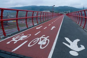
Next to the Casa Consistorial we pull right (eye because the metal plate that signalizes goes unnoticed), down the street of Aizpuru. The border between Sestao and Portugalete is almost an imaginary line and we are soon heading towards the mouth of the Nervión, where a funambulatory structure crosses the estuary over several towers. This suspension bridge, with the shuttle function between Portugalete and Getxo, was opened in 1893 and is since 2006 World Heritage Site. It covers 160 meters in length and is supported by four towers that rise to over 60 meters in height. If time is available, it is advisable to take a ticket to visit the walkway. The views towards the interior of the estuary and the mouth with the port of Bilbao are great.
At the height of the church of Santa Maria we turn right to visit it and after surrounding it we continue through the Canton of Church. Then we can turn right onto Coscojales Street and then take Santa Clara Street, the first on the left. It flows into Casilda Iturrizar Street. In number 8 is the hostel, which is enabled in the months of July and August on the ground floor of the Ramón Real building in Asúa.
- Km 19.7. Portugalete (All services)
The difficulties
Remarks
In images
What to see, what to do
The hostels

¿Do you want to send any photo of "The Camino de Santiago"?
If you have any photos of "El Camino de Santiago" that you want to share with us, you can send them to us and enlarge the photo gallery
Forum: What pilgrims think about the Camino de Santiago
See all