Article translated by an automatic translation system. Press here for further information.
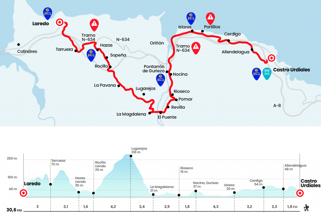
Castro Urdiales to Laredo stage
Easy journey to enjoy the landscape, shrines and monasteries
Information about the stage 11: Castro Urdiales to Laredo stage
Enlarge map
The route
Caution: The hostel in Islares is CLOSED until further notice.
- Km 0. Castro Urdiales - Centro (All services)
We left the hostel and continued on the right hand, ending the climb to Campijo. On the upper we go to the left, towards the campsite, and we pass under the highway of the Cantábrico. Leaving the tunnel we left on the right and visited several homes in the Castreño district of Campijo. In the next bifurcation the Camino continues on the right, leaving the Camping on the other side, and already continues on the trail and a stretch of road to Allendelagua, which has a Good of Cultural Interest: the ruins of a medieval Templar castle situated on the hillside of Mount San Antón. At the entrance we pass by the church of San Marcos (Km 1,8) and cross the Castreña population to come down next to the A-8. The itinerary goes parallel to the highway, leaving aside the crossing to the Saltizones neighborhood (Km 3) and goes further below to climb to Cerdigo, another Castro’s pedanía represented by his church of San Juan, which still maintains its Romanesque apse, dated around the 13th century. The temple is just in. We went down to the center.
- Km 4.1. Cerdigo
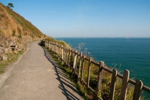
We crossed the N-634 and then passed by the cemetery. The Camino runs north to approach the coast after a portillo and a tunnel of Mediterranean vegetation. Countless rounds form a rewarding coastal path, with multiple portilles, which transports us to Islares. Luciano Huidobro states that walkers had five beds at the Hospital de la Vera Cruz. At the entrance the Camino passes by the church (the hostel of pilgrims is next door) .
- Km 7.3. Islares (Hostel. Bar. Store)
We continue down Casal Street. The services are located on the edge of the National and can then continue through it until linked to the Camino. Official signage leads next to the Camping de Arenillas, where there is a restaurant bar and a shop. From this point we find a dangerous section through the arcén of the N-634. We can then use a few rounds behind the right shoulder. We see the estuary of Oriñón, mouth of the river Agüera that has a marsh area. At this stage, the dilemma arises again as to whether to continue along the N-634 to Laredo, as well as to follow the official Camino. Although longer is the option we recommend. Next to the viaduct the Official Road leaves the road and goes up to Nocina one of the more than twenty neighborhoods that groups the municipality of Guriezo.
- Km 11.6. Nocina (Hostel. Bar)
If anyone wants to stay in the hostel of the Pontarrón de Guriezo he must continue a few more meters through the N-634 to the bar El Pontarrón and collect the keys there. The hostel is a few meters ahead of the bar, at the foot of CA-151. From Nocina we descend to CA-151, with pedestrian rail, and we approach the Rioseco neighborhood. On the thick hill stands the monumental San Vicente de la Maza, an excellent Renaissance example taken by the witness of a monastery.
- Km 13.4. Rioseco (Bar)
Eye, because right at the entrance of Rioseco you have to turn 90º to the left to reach the Pomar neighborhood. There is a fountain and a utility room and after crossing the stream of Rioseco we continue on the right to an urbanization and the hermitage of San Lorenzo. Later we went next to San Blas, in the 17th century and located in a beautiful location of the Revilla district (Km 14.6). After a line we reached the CA-520 and we followed right to a roundabout, where is the El Puente neighborhood. Here is the City Hall of Guriezo and much of the valley services.
- El Puente (Bars. Shops. Health Center. Pharmacy. ATM)
The Camino continues from front to the neighborhood of La Magdalena. Before you have to cross the river Agüera. It seems that the ancient pilgrims who did not take the boat in the estuary, went so far to save the trail on foot. Just before the church we leave the road on the right (Km 16,3) and give a rodeo to the house La Riera, where the ascension begins. A runway gives rise to a silent eucalyptus forest. At half an hour we left the runway that goes to the Lugarejos district (if someone needs water it can be diverted) (Km 18,7), and then we killed the climb.
After a flat section sprinkled with alms and heather, with the rock of the bees in front of the right hand, we started the descent through a suggestive and isolated landscape. At once we passed by a house called La Pavana (Km 21) and then under the viaduct of the A-8. It is worth stopping and contemplating the emerald green valley of Liendo, a Jacobean step towards Laredo. Under the shelter of Mount Candina, more than a dozen neighborhoods settle between pastures and orchards. As soon as we pass the viaduct, we go down to the right to the Sprinkllo district (Km 22,9). Then we cross the Sopeña district and arrive shortly to the Hazas district, capital of the valley and another possible and comfortable end of stage. It concentrates all the services and has a good hostel of pilgrims, which we find right behind the church of Nuestra Señora de la Asunción (Km 24.5).
- Km 24.5. Hazas (Liendo) (All services)
We continue forward on a road that goes up to the N-634, through which we continue the climb. At one point the signage takes us from the National on the left to go down to Tarrueza (Km 27,6), (although it is reflected in the map of the stage it seems to us a somewhat absurd deviation, as it goes downhill to Tarrueza and then climb all those meters and end up coming back to the National). Question of tastes if to take the diversion or continue through the National. After p.k 169 we turn right through the La Arenosa neighborhood to the lookout bar La Torre, with an excellent panorama on which was one of the four villas of the Costa de la Mar.
After the bar we go down to the left by a rail, (a pity that the wall deprives us of the panoramic) next to a cruise, and as soon as we cross the access road we take from the front stairs. They go down to the door of San Lorenzo or La Calzada arch, which gives access to the chapel of the Holy Spirit and Laredo. San Francisco Street is just the street on the left, which leads in a few meters to the same monastery, where is the hostel Casa de la Trinidad (Km 30.6) . Hostel Buen Pastor is also located opposite the convent.
- Km 30.6. Laredo (All services)
The difficulties
Remarks
In images
What to see, what to do
The hostels

¿Do you want to send any photo of "The Camino de Santiago"?
If you have any photos of "El Camino de Santiago" that you want to share with us, you can send them to us and enlarge the photo gallery
Forum: What pilgrims think about the Camino de Santiago
See all