Article translated by an automatic translation system. Press here for further information.
Stage of Triacastela a Sarria
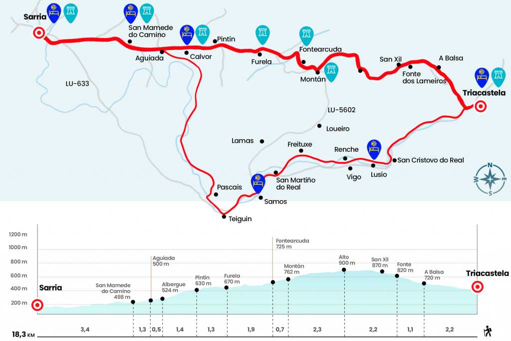
You can choose the Samos or San XII route, both recommended
Information about the stage 26: Stage of Triacastela a Sarria

Enlarge map
Points of interest in the stage 26: Stage of Triacastela a Sarria
The route
By San Xil:
- Km 0. Triacastela (All Services)
Those who have stayed in the public hostel must cross Triacastela down the central street until the exit of the population. The Camino splits and one of the itineraries has to be chosen. On the left hand, by the LU-633, the route progresses to Samos and his Benedictine monastery and from there continues to Sarria. On the right hand part the itinerary for San Xil, 6.5 kilometers shorter although it exceeds a level of 238 meters the first 5.5 kilometers.
At the exit of Triacastela we turn right and cross the LU-633. On the right, slightly above, the diversion to San Xil is born. We took it, and after a short stretch, we left the road on the right to continue on a paved runway. Then we take a road that leads to A Balsa.
- Km 2.2. A Balsa (Hostel)
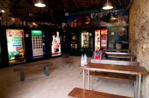
At a more pronounced cost, we continue surrounded by lush oak trees to get back on the road, just at the height of the Fonte dos Lameiros (Km 3,3). A good repecho by asphalt leaves us up to San Xil. The population is left and a soft drink machine at the foot of the road is all offered for these sites (Km 3,9).
The route continues its ascent on the road, initially on false plain to harden later, to the vicinity of the upper Riocabo (Km 5.5). On the top we left the road to enjoy the most beautiful section of the stage. Closed hallways of chestnut trees, oak trees, and birches escort us. The descent to Montán - a village that barely roars - is dangerous as the floor is made up of stone slabs.
- Km 7.8. Montán
We continued the descent to the village of Fontearcuda, where the Jacobean mojón announced us the 121.5 kilometers.
- Km 8.5. Fontearcuda
The Lower Road of Fontearcuda to the road and it crosses (attentive to signaling because you have to look for the Cairn) to take a path that avoids the long road that passes through Zoo. We save a stream and move along the path that goes back to the road. The steep stains of oak and chestnut give way to the meadows. By asphalt we finally arrived at Furela, where we can recover forces in the bar located at the foot of the road.
- Km 10.4. Furela (Bar)
We cross through the town and cross the road next to the sign announcing the entrance to the Concello de Sarria (km 10.7). One kilometer left to reach Pintín, which also offers a bar and restaurant.
- Km 11.7. Pintín (Bar)
The Camino remains on the road LU-5602 and one kilometer later crosses it to flee through a wooded section that fits a prolonged curve. We go back to the road and pass by the public hostel in Calvor. The parish of the same name is behind the hostel, on the left hand.
- Km 13.1. Calvor (Hostel)
Five hundred meters later we briefly detach from the LU-5602 to enter Aguiada.
- Km 13.6. Frozen (Bar)
After the population we return to the arms of the road along a parallel path. The Camino leaves a hostel Paloma and Wood surrounded by a garden (Km 14,3) and continues along the andadero leaving aside the crossing to Airexe. On the left of the road is the parish of San Mamede do Camiño (14.9).
With views of Sarria, the ground walker continues to make progress at the foot of the LU-5602 by small slides. We passed the Carballal Mojón 114 km and the crossing to Ferreiros, which is left to the right. Immediately we arrive at the campsite Vila de Sarria, with 12 places in bunk beds for pilgrims located in a couple of shops (see section observations), and we leave Mendros to the right.
So we entered Sarria in front of the first hostel. Not in vain this capital of Concello has the highest number of hostels of the French Way and is the place chosen by many walkers to start the pilgrimage, as it is in the ideal distance to get the Compostela. The rustic José Sánchez leaves us at the foot of the rustic Calvo Sotelo, which we cross to continue in front of the rustic do Peregrino. We saved the Sarria River by a bridge and crossed in Benigno Quiroga to turn next to the Peregrinoteca. A staircase goes up to the entrance of the Major, which should change its name to the "Hostels Rua", as more than 5 are counted, including the public.
- Km 18.3. Sarria (All Services)
By Samos:
The distance covered by this itinerary is 24.7 kilometers. The Jacobean mojones that mark the distance of medium in half a kilometer will not be seen in this itinerary, populated however by the characteristics yellow arrows. The route accompanies the passing of the Sarria River, also known as the Oribio River, as it is formed on the slopes of this mountain in the Concello de Triacastela.
You have to take the bifurcation from the left. He leaves Triacastela to finally reach the LU-633 road. This, by favorable terrain reaches San Cristovo do Real (Km 3.8), parish of Concello de Samos already documented in 1175. In this parish is the pazo of Lusío of 1551 and the Casa Forte, hostel of the Xunta opened in 2010. From San Cristovo, a path that accompanies the river on the right progresses to Renche, another parish of Samos also documented in 1175. (km5.5) Across the LU-633 is Vigo.
From Renche, again by beautiful landscapes next to the Sarria u Oribio valley, progress to the immediate Lastres, a village of Reche, and you reach Freituxe (Km 7.3). Then we went up and down to the parish of San Martiño do Realcon rural romanesque church (Km 8.4). At the exit of this population we return to the LU-633 and cross it to head to Samos, capital of the Concello where the famous Benedictine monastery is located and which has all the services (Km 9,8).
After Samos he returns to the company of the road to Teiguín (Km 11,7), village of the parish of Santa Uxía de Pascais, to which we subsequently climbed (Km 12,8). In Teiguín we have already said goodbye to the company of the road and from the parish of Santa Uxía de Pascais we return to the nearby rumor of the river to, first by roads and later by roads and asphalted sections, reach the tiny villages of Gorolfe, Veiga (not passing through Reiriz, which is located in a high) and Sivil, the last place belonging to the parish of the By the way, between Veiga and Sivil the river Sarria is crossed by a medieval bridge with chapel at the entrance
.
We access the Concello de Sarria by the village of Dogs, belonging to the parish of Calvor and showing a pazo with a tower linked to the families Monseiro, González, Losada and Sarmiento. From here we save the LU-5602 to finally reach Aguiada, where we link to the itinerary that comes from San Xil (Km 20). From here to the rustic Mayor de Sarria there are 4.7 kilometers.
The difficulties
Remarks
In images
What to see, what to do
The hostels

¿Do you want to send any photo of "The Camino de Santiago"?
If you have any photos of "El Camino de Santiago" that you want to share with us, you can send them to us and enlarge the photo gallery


Forum: What pilgrims think about the Camino de Santiago
See all