Article translated by an automatic translation system. Press here for further information.
Stage of Puente la Reina/Gares a Estella/Lizarra
Welcome to the middle; cobbled streets and Romanesque bridge
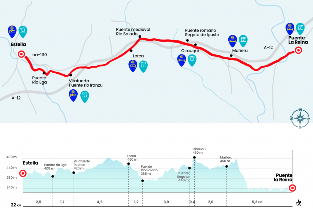
Information about the stage 5: Stage of Puente la Reina/Gares a Estella/Lizarra

Enlarge map
Points of interest in the stage 5: Stage of Puente la Reina/Gares a Estella/Lizarra
The route
- Km 0. Puente la Reina (All Services)
The vast majority will have stayed in the hostels located at the entrance of Puente la Reina, so we wake up from sleep on Crucifix Street, passing under the arc that connects the church with the Sanjuanist convent, and cross the national to enter Calle Mayor. On the right is the church of Santiago with its rich front page from the beginning of the 13th century. At the end of the street, the monumental Romanesque bridge over the Arga that gives name to this locality. It is certain that it was built for the passage of the pilgrims, although it is not so much that it was ordered to be lifted by the queen Doña Mayor. We feed history across it and turn left to pass the national and bid Puente la Reina for Zubiurrutia, the neighborhood of the nuns where there is a convent of the Commander of the Holy Spirit. We continue for a couple of kilometers the course of the Arga River by its right margin and we are moving away from its flow to temporarily turn north-west. The change of direction entails facing a hard hill under a repopulated pine grove that dies next to the A-12, the highway of the Camino. We entered the region of Val de Mañeru and reached the village that gives name to the valley.
- Km 5.2. Mañeru (Hostels. Casa Rural. Bar. Store. Office. Pharmacy)
Pueblo de vino, Mañeru is crossed by its southernmost part (calle de la Esperanza and plaza de los Fueros) and is abandoned by Calle Forzosa. At the exit we see one of the postcards of the Camino appear on the horizon. It has everything: a path surrounded by cereal and vineyards, transited by pilgrims, moving towards a medieval town situated on a hill. The town in question is Cirauqui and to reach the center you have to sweat the nice through its network of steep streets. One of the gates of the old wall is accessed to the streets Santa Catalina and Portal and the City Hall. Next to the route, after a few steps to the right hand, is St. Román, a church of characteristic Romanesque cover and Arab reminiscences.
- Km 7.8. Cirauqui (Hostel. Bar. Store. Office. Pharmacy. ATM)
We enter the City Hall by one of its arches, where they usually leave a stamp to mark the credential, and we descend to the outskirts of the town to step a heap of the past. It is a stretch of Roman road and a bridge of the same time, transformed in the 18th century, that crosses the waters of the Iguste race. After a sink comes another bridge lacking historical comments that allows safe passage over the A-12 motorway. The day continues on the runway or on intermittent road remains and a one-arch bridge over the Dorrondoa race (Km 9,4).
Two kilometers later we stood on a local road, passed under the viaduct of the Alloz canal, built in 1939, and ended up on the shore of the Salado River. Codex Calixtinus of the 12th century is released with saña: "by the place called Lorca, by the eastern area, runs the river called Salado: Beware of drinking on him, neither you nor your horse, for it is a deadly river!" (km 12.1) The waters are saved, rich in salts but not lethal, by the medieval bridge of ojival arches and we leave the river and poetry to face a demanding kilometer to Lorca, the town of Yerri valley.
- Km 13.3. Lorca (Hostel. Bar. Store)
At the entrance we receive the prominent apse of the church of San Salvador. Calle Mayor guides us from end to end and on the outskirts our itinerary coincides with that of a local path that heads to the cross of Maurien. Always on the routes of concentration we reach an underground step under the highway and we end up in Villatuerta. It is the newly built urbanizations that draw the direction to follow to the Romanesque bridge of the Iranzu River, which divides this newer part with the most historical nucleus.
- Km 17.8. Villatuerta (Hostel. Bars. Shops. Office. Pharmacy. ATM)
By the rustic Nueva, next to the consistorial house, we climbed to the plaza where the gothic church of the Annunciation is located, with a cathedral bearing. In the entrance patio there is an image of San Veremundo, patron of Villatuerta and great benefactor of the Camino de Santiago as its contemporaries Santo Domingo de la Calzada and San Juan de Ortega. On the street Camino de Estella we continue the path towards the silhouette of the chapel of San Miguel.
It is left to the left and descends to a small bowl at the foot of the NA-132. Tragically, the Canadian pilgrim Mary Catherine passed away. A stone milestone crowned by a virgin and a plate will always remember it. Rest in peace. We save the road for an underground step and go down a path to a modern and abombated bridge over the Ega (Km 19,5). The course of this river will take us to the doors and the origin of Estella, the rustic Curtidores, where is the orientation service to the pilgrim Ordoiz, who gives the witness to the Rúa, where the hospital of pilgrims is located.
- Km 22. Estella (All Services)
The difficulties
Remarks
In images
What to see, what to do
The hostels

¿Do you want to send any photo of "The Camino de Santiago"?
If you have any photos of "El Camino de Santiago" that you want to share with us, you can send them to us and enlarge the photo gallery


Forum: What pilgrims think about the Camino de Santiago
See all