Article translated by an automatic translation system. Press here for further information.
Stage from Terradillos de los Templarios to El Burgo Ranero
The pilgrim leaves behind Palencia to enter León by Sahagún
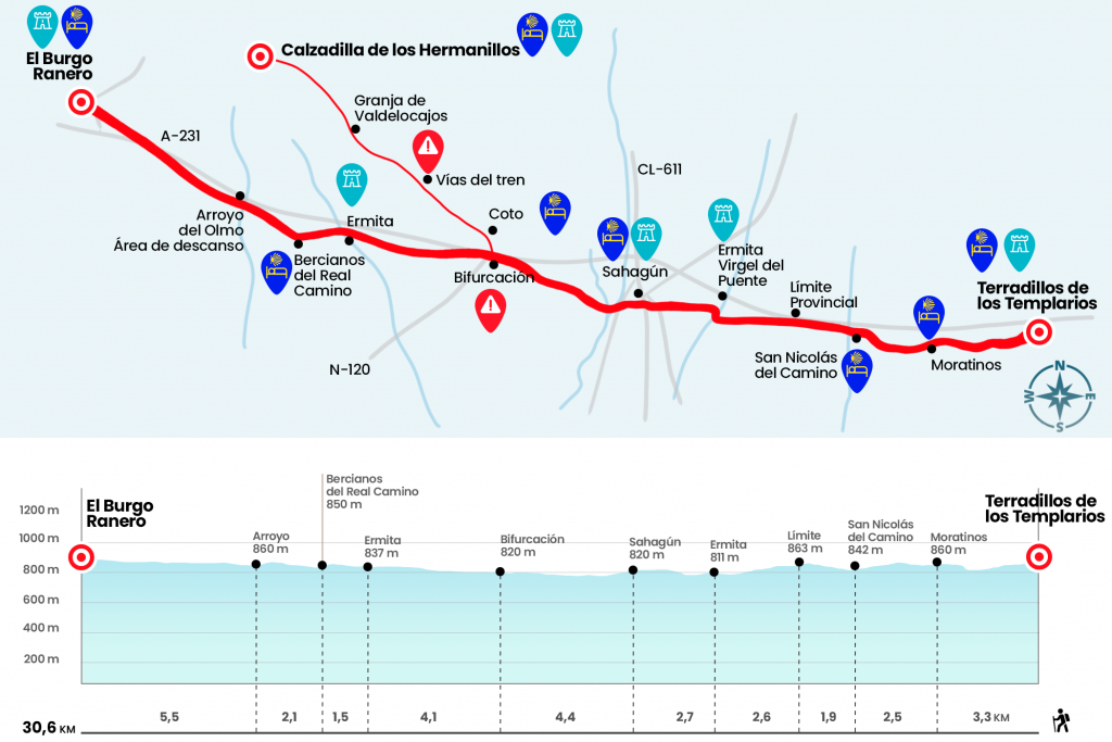
Information about the stage 17: Stage from Terradillos de los Templarios to El Burgo Ranero

Enlarge map
Points of interest in the stage 17: Stage from Terradillos de los Templarios to El Burgo Ranero
The route
- Km 0. Terradillos de los Templarios (Hostel. Bar. Small food store in one of the hostels)
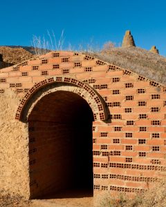
We abandoned the former Templar Ordinance of Terradillos by a piste that dies at P-905, also marked P-973 (Km 1.4). A short section of the road gives way to a track that advances between the cereal and the rows of chopsticks, arranged next to the streams of San Juan and the Strike. This landscape accompanies us to Moratinos, the penultimate town of the Camino de Santiago as it passes through Palencia that looks like excavated wineries and adobe houses: a mass of mud mixed sometimes with straw and used to raise walls and walls.
- Km 3.3. Moratinos (Hostel. Hostel. Bar in the hostel itself)
At the height of the church of St. Thomas Aquinas we turn right and leave the village. Two and a half kilometers separate us from San Nicolás del Real Camino, the last palentino town.
- Km 5.8. San Nicolás del Real Camino (Hostel. Bar in the hostel itself)
At the exit of St. Nicholas we save the Sequillo River and turn right to take the path of pilgrims that advances along the N-120. One hundred and fifty meters north of this runs the A-231, the highway of the Camino de Santiago. Along the way we cross the boundary between Palencia and León, the last Castilian province that holds the record of kilometers of the Camino. A total of 214.4 awaiting discovery (Km 7,7). We progressed parallel to the N-120, and after crossing it, we passed the Valderabuey River through a stone bridge. Thus we access a wooded esplanade where the chapel of the Virgen del Puente is located, in the Mudéjar Romanesque style (Km 10.3).
After one third of the stage, the Camino leads us to Sahagún. Avoiding the N-120 below (Km 11,6) we access the urban area of this Leonese locality. After Ronda de Estación Street we crossed the bridge over the roads, passed by the municipal hostel and continued through the streets La Herrería and Antonio Nicolás.
- Km 13. Sahagún (All Services)
Sahagún exhibits the Mudejar art in the churches of San Lorenzo and San Tirso, raised by alarifes that dispelled the stone and burned their works with brick. Also, at the end of Antonio Nicolás Street, we can see the baroque arc of San Benito. Later, we saved the river Cea - affluent of the Esla - by the bridge Canto, which fired Sahagún (km 13.7).
The day continues along a tree-lined walk parallel to the access road to the N-120. At the foot of the national road, before passing the diversion to Mayorga, the trees disappear and the walk becomes a walker. By begging the vegetation that separates us from the road, we saved a creek and a half kilometer after crossing the N-120. In short, along with a marquesina, a stone cartel warns, badly, of the double alternative that presents itself: from the front it continues the Royal French Way to Bercians and Burg Ranero. To the right, saving the A-231 highway by a bridge, you immediately access Calzada del Coto and from this population to Calzadilla de los Hermanillos. There is also the option of entering Calzada del Coto and returning to the Royal French Way by another bridge located at the end of the town (in fact the original fork has always persisted at this point to take one route or another). Both routes meet again on the next day (Km 17.4).
We continue ahead of the Real Camino Francés (the alternative for Calzada del Coto and Calzadilla is briefly described in the comments section). A dirt lane, built ex profeso for pilgrims and shaded by an endless line of false bananas (Acer pseudoplatanus), will accompany us for the next 32.2 kilometers. A paved track used by pilgrims by bike flows next door. The transit to Bercianos del Real Camino is quite monotonous and, after an hour of walking, on the left hand, we see on a esplanade the chapel of Nuestra Señora de Perales (Km 21,5). Later, after crossing a stream and leaving aside the cross in memory of the German pilgrim Manfred Kress, we entered Bercianos del Real Camino.
- Km 23. Bercianos del Real Camino (Hostels. Bar. Store)
At the entrance of Bercians greets us a fountain decorated with a vieira. We cross the village through its Calle Mayor in the company of adobe, basic material of the traditional architecture of these first Leonese villages. In Bercians, a pair of ultramarines and a bar allow us to replenish forces to face the last part of the stage. We left the village to resume the trail of false bananas, in turn contemplating the small vine plots that sprinkle the fields. After two kilometers we arrive at a rest area next to the Olmo Creek (Km 25.1).
Then, the wooded track advances to a viaduct of the A-231 (Km 28,7) highway and then to El Burgo Ranero. We crossed a road to enter this town at the height of a child memorial cruise. It is possible to continue in front of Calle Real or to borrow the village on the road to the hostels of pilgrims.
- Km 30.6. El Burgo Ranero (Hostels. Bars. Store. Pharmacy)
The difficulties
Remarks
In images
What to see, what to do
The hostels

¿Do you want to send any photo of "The Camino de Santiago"?
If you have any photos of "El Camino de Santiago" that you want to share with us, you can send them to us and enlarge the photo gallery


Forum: What pilgrims think about the Camino de Santiago
See all