Article translated by an automatic translation system. Press here for further information.
Stage from O Cebreiro to Triacastela
Renew forces in this short period and visit the Church of San Xoán
Information about the stage 25: Stage from O Cebreiro to Triacastela
Enlarge map
Points of interest in the stage 25: Stage from O Cebreiro to Triacastela
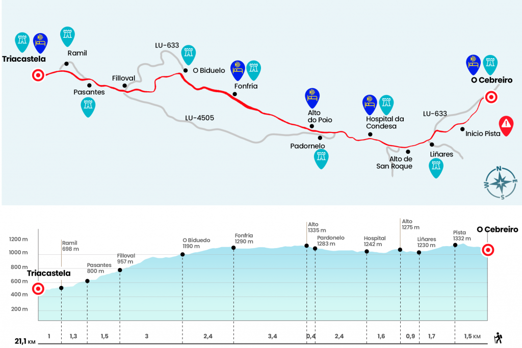
The route
- Km 28.4. O Cebreiro (Hostel. Rural Houses and Pensions. Bars. Store)
If the fog does not prevent it by hiding the valley, seeing sunrise from O Cebreiro, next to the temple of Santa Maria la Real, is a privilege that gives us the Way that we cannot reject. Today, at last, we immerse ourselves in the land of Santiago, that of fog and orballo; that of the Celtic castros and the mines desired by the Romans; of endless lomas, fragas of oak and chestnut souths. The official signage marks 151 kilometers to Santiago, ours 154.7. We started the twenty-fifth stage above the pilgrim hostel. Sheltered by the vegetation of the mountain, we climb from 1296 meters to 1370 (the highest point of the French Way in Galicia) in the vicinity of the Teso da Cruz and Monte Area. From that point we come down to a wide forest track (Km 1,5).
Drive to the first parish of the day. In Galicia the municipalities are called concellos, to which belong different parishes that in turn encompass different places or villages. Towards the south, on the left hand side of the forest track, the view is recreated in an endless number of tupids of ferns, oak, chestnut and grassland that form, among others, the O Courel mountain range. The forest trail ends at the foot of the LU-633, where is the parish of Santo Estevo de Liñares, with a single-nave prerogative church.
- Km 3.2. Liñares (Hostel. Bar serving no meals. Store)
After the temple we cross the LU-633, faithful companion during today’s stage, and we take a path very close to the road that throws us with its beech, bait and other catalog of Atlantic species. The first stop, San Roque's, does not take long to arrive. On the other side of the LU-633, at 1270 meters and facing a wide panorama, the plastic sculpture of a medieval pilgrim advancing against the wind is raised. It was immortalized in bronze by the artist José María Acuña (Km 4.1).
The path follows the LU-633 route and drops slightly to 1,205 meters. Subsequently, a false plain brings us to Hospital da Condesa the second inhabited nucleus of the day. The Jacobean mojón marks the 145.5. In this town we will probably have one of the first contacts with the "Galician blondes", the cinnamon cows appreciated for their meat.
- Km 5.7. Hospital da Condesa (Hostel. Bar)
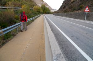
We left this cowboy village and continued on a path to the LU-633 guardarrail. Later we took the detour to Sabugos and Temple but immediately fired the paved section by a road that brings us closer to Padornelo. It's the realm of stone and slate slabs.
- Km 8.1. Screwdriver
On the way out of this small parish we face a very long but short cost for which we reach the high do Poio. A bar - hostel and a inn strategically receive walkers, anxious to stabilize their heart rate after such an acceleration.
- Km 8.5. Alto do Poio (Hostel. Bars)
More than three kilometers of path attached to the LU-633 separate us from the next population. In the whole of this section we are practically plain because we are only down 45 metres in altitude. So we got to Fonfrio, the nucleus of Pedrafita do Cebreiro, with bars and hostel. If we spend relatively early and have not opened the bars yet, it is likely that some locals will welcome us with a succulent tower of fried milk cakes.
- Km 11.9. Fonfriar (Hostel. Bar)
We traversed Fonfrio and again, next to the inseparable LU-633, we returned to the path that leads us by identical landscape to O Biduedo, 2.4 kilometers away. In this whole section we descend exactly one hundred meters (Km 14,3).
- Km 14.3. O Biduedo (Bar)
After O Biduedo, already from the Concello de Triacastela, the descent began to become apparent. We are only 6.8 kilometers away from the end of the stage and we still have to go down about 530 meters of altitude. On the downhill, the road seeks to get rid of the LU-633 and to tackle the road’s turns and riots. A steep curve allows us to see Mount Oribio, 1443 meters high. On the right, at the bottom of the valley, is Triacastela. The village after O Biduedo is Fillobal. In this village there is a hostel and a bar-restaurant, Aira do Camiño, with an internet access point and a small shop.
- Km 17.3. Fillobal (Hostel. Bar-Shop)
After Filloval we crossed the road and we continued to descend between trees to cross again one kilometer later, next to a small merchant. So we entered Pasantes (Km 18.8), stretched village with chapel that we went through under the claim of the particular sale of raspberries. The journey continues to the village of Ramil (Km 20.1), with centennial chestnut on the edge of the road, and almost glued to Triacastela. The public hostel is located in the same entrance, in a left-hand campground and the rest, a large selection of private hostels, in the center of the population.
- Km 21.1. Triacastela (All Services)
The difficulties
Remarks
In images
What to see, what to do
The hostels

¿Do you want to send any photo of "The Camino de Santiago"?
If you have any photos of "El Camino de Santiago" that you want to share with us, you can send them to us and enlarge the photo gallery
Forum: What pilgrims think about the Camino de Santiago
See all