Article translated by an automatic translation system. Press here for further information.
Logroño to Nájera Stage
This stage does not present any significant difficulty and a lot of motivation
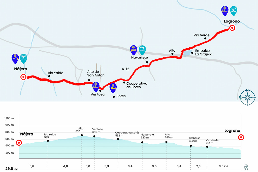
Information about the stage 8: Logroño to Nájera Stage
Enlarge map
Points of interest in the stage 8: Logroño to Nájera Stage
The route
- Km 0. Logroño (All services)
As a fish out of the water, this is how the pilgrim feels in the large cities of the Camino. The capital of Riojana is by no means one of the worst. Ruavieja Street links to Barriocepo and it leads us to the Plaza de Santiago, where the homonymous church rises (with hostel and where they seal and facilitate the credential). Later, passing under the arch known as Puerta del Camino, we reached the circular fountain where Calle Marqués de Murrieta was born. More than a kilometer of sidewalk, shops and pedestrians take us to the train tracks and three hundred meters further, next to
a Nissan dealer, we turn left to continue to the San Miguel Park. Between gardens we reach the circumvalation tunnel and immediately alpaseo
- called here via verde - which leads to the park of the Grajera (Km 3.5).
A section of the promenade is flanked by cypresses and reminds of the images of the Appia Way, famous road starting from the very forum of ancient Rome. Behind a playground and a sports area is the dam of the Grajera reservoir, built in 1883 on a lagoon in order to accumulate the water of the Iregua River and water the orchards located south of the capital. Today it is an enviable recreational environment where fishing, walking, merging or, just, resting
(Km 5,8).
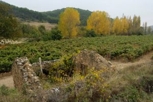
After the prey, you will soon reach the environmental didactic classroom and cross the limits of the park through a paved runway that advances among
soft vine populations. Leaving aside the diversion to the golf course (Km 8) we started a demanding repecho that presents us with magnificent views. In the foreground the vines, an arboreal mass surrounding the reservoir in the second term and the bottom Logroño. With this formidable view we reach the high (Km 9.2) and descend
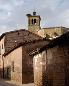
Navarrete next to a metal fence stitched by the crosses left by the pilgrims. The silhouette of a bull by Osborne also accompanies us on the downhill and, already on the plain, we finally crossed over the AP-68 to reach the ruins of the pilgrim hospital of San Juan de Acre, founded towards 1185 by Doña María Ramírez. A line separates us from Navarrete, village of potters located on the Tedeón hill. La Cruz Street surrounds the city center and climbs to the church of the Assumption. Navarrete has enough establishments to satisfy the appetite, which is already raging after tremors
of walking.
- Km 12.7. Navarrete (All Services)
We entered the town by calle de la Cruz (border of the old wall) after crossing the road and took Calle Mayor Baja to the right with climb to the church. Then we take the exit of the population by Arrabal Street and continue from the front by San Roque Street. After the cemetery, which looks on the front cover and the windows of the hospital of San Juan de Acre, we took a path that meets the vines, olive groves and fruit trees that populate the private gardens. The road dies next to the Sotés Wine Cooperative, where we cross the road to Sotés. In this population is the hostel San Martín, opened in May 2013.
- Km 16.1 Transfer to Sotés (Hostel. Bar. Pharmacy)
We take a paved runway that reaches the edge of the highway. Parallel to the A-12 we advance to the detour leading to Ventosa (Km 18.1). Here we have the possibility of heading towards this community - with hostel and several bars - or continue in front. We choose to visit Ventosa and travel the 1.3 kilometers of clay track that separates us from it.
- Km 19.4 Ventosa (Hostel. Bars)
We arrived at the LR-341 and the Camino continues through the arche without, paradoxically, accessing the urban area of Ventosa, over which the church of San Saturnino stands out. In short, next to the Alvia wineries, a stony road guides us to the top of San Antón in short and easy climb. From this watchtower the view clears and shows us the valley of the Najerilla, clayey land covered, of course, with twisted branches arranged in separate terraces of low mountain. The panoramic also discovers Nájera, apparently close but really distant (Km 21.2).
We went down to the pass that saves the N-120 and went on to a phone repeater, located at the Poyo de Roldán, where the legendary battle between Roldán and the giant Ferragut took place. We also have a guardaviñas, a circular construction that served as a refuge for farmers and used by the field guards to guard the crops (Km 25).
Nájera is still not present and after an aggregate factory we cross the river Yalde by a small wooden and concrete bridge (Km 26). We walked away from its course and after a kilometer and a half finally, now yes, we crossed the N-120 (very cautious) to enter Nájera. However, we still have two kilometres of
urban crossing. We pass by the sports club and continue along the avenues of Logroño and San Fernando to the bridge over the Najerilla River. After crossing it you have to twist to the left and move along the side of the river to the hostel.
- Km 29.6. Nautical (All Services)
The difficulties
Remarks
In images
What to see, what to do
The hostels

¿Do you want to send any photo of "The Camino de Santiago"?
If you have any photos of "El Camino de Santiago" that you want to share with us, you can send them to us and enlarge the photo gallery
Forum: What pilgrims think about the Camino de Santiago
See all