Article translated by an automatic translation system. Press here for further information.
El Burgo Ranero to Leon stage
Intense stage that can be divided into two overnight stays in El Burgo Ranero
Information about the stage 18: El Burgo Ranero to Leon stage
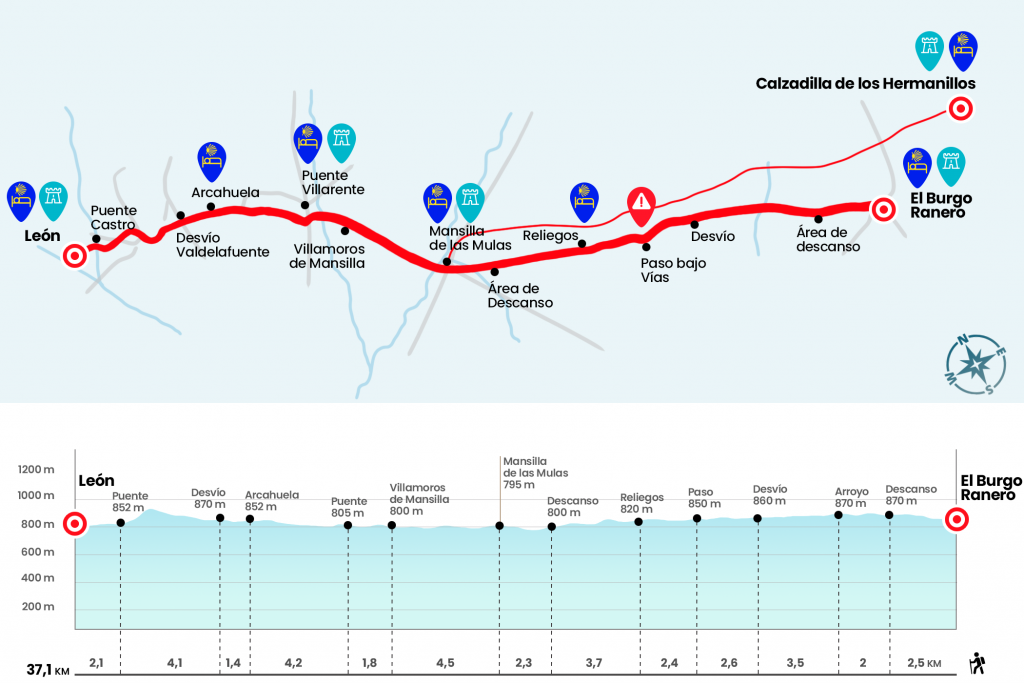
Enlarge map
Points of interest in the stage 18: El Burgo Ranero to Leon stage
The route
- Km 0. El Burgo Ranero(Hostels. Bars. Store. Pharmacy)
At the exit of El Burgo we find the lagoon of the Apple. They are relatively abundant in these confines of Tierra de Campos and were used until recently as a watering hole for animals. Today they constitute the habitat of certain species of amphibians, raptors and analogues. We resumed the wooded runway of the Royal French Way through a landscape that stood on the one of yesterday: impressive cultivated plains, with little ripples and almost deforested. Two and a half kilometers from El Burgo Ranero we pass a rest area located near the stream of the Valle de la Granja (Km 2.5) and two kilometers later, in a slight vaguada, another stream flows: that of Valdasneros (Km 4.5).
In half an hour of monotony we left a track and school of ultralights (Km 7) and a kilometer later the diversion to Villamarco (Km 8). The law of the straight line gives us a breath when the track draws a curve and saves underneath the train tracks (Km 10,6). In the back vaguada we pass the stream of Valdearcos and after passing a slight repecho we dropped to the town of Reliegos, clutched until the last moment. In the same entrance there are traditional wineries in brick and adobe, used to preserve wine but mainly as a meeting place. We traversed Reliegos end-to-end, smelling the wooded track down Real Street, where a meteorite struck in 1947.
- Km 13. Relics(Hostels. Bars)
We leave the pediment aside to immerse ourselves next to the false bananas in the cereal plains, decorated by giant sprinkling irrigation structures. The saying “from Reliegos to Mansilla, the well-measured truce” sets the distance of a truce (between 5,573 and 5,914 meters) between the two localities. Almost four kilometers after Reliegos, after passing under the electric towers, there is a rest area on the edge of the wooded runway (Km 16,7). We give the definitive goodbye to the artificial runway, save the N-601 (Adanero – León road) by a viaduct and draw a irrigation canal to enter Mansilla de las Mules. We discovered the old walled city as it passed the Castle door, in lime and rolled singing. On Santa Maria Street the tower of the church is doomed.
- Km 19. Mansilla de las Mules (All Services)
The Camino crosses Mansilla and leads to the bridge over the Esla, Latino Astura. As soon as you cross the bridge, you have to take a path that is born to the left and advances parallel to the N-601, along with the acequias, the cornfields and some other acacia. So we arrived in an hour at Villamoros de Mansilla.
- Km 23,5. Villamoros de Mansilla(Shop)
At the entrance we leave the road protection to take the arcén of the N-601. We pass Villamoros on the road and again on the parallel path we reach Puente Villarente, where we cross the river Porma next to the bridge of medieval origin. We crossed Puente Villarente following the route of the N-601, which starts in two this town with a multitude of services.
- Km 25.3. Puente Villarente(All Services)
If we walk on the sidewalk of the left, when we reach an office in Caja España, we cross the pedestrian walkway and continue on the right sidewalk. At the height of the Avellaneda Restaurant we distance a little from the N-601 to take a track that is born to our right (Km 26,3). For it we saved the Arriola canal, crossed later the road to Sanfelismo and continued forward. After a repeat, at the beginning of which they have enabled an indoor rest area, we reach Arcahueja.
- Km 29.5. Arcahueja(Hostel. Bar)
After this population, the section worsens with several slides. We left aside the diversion to Valdelafuente (Km 30.9), crowned a small tachuela and followed towards a polygon located at the foot of the N-601. By a pedestrian walkway, enabled in early 2010, we saved the road node of the N-601 and headed towards Puente Castro, neighborhood of León separated from the city by the river Torío. We enter Puente Castro through Calle Avenida de Madrid, by which the Camino de Santiago converges, at the height of No. 83 comes Avenida De la Lastra where the hostel Santo Tomás de Canterbury is located, but if our intention is to continue to León at the crossing we continue right on the avenue of Madrid to reach a walkway and cross the river Torío. On the right is the 18th century stone bridge.
Overcome the cauce – already in León – we take from front the street of Mayor Miguel Castaño and continue through it to the plaza of Santa Ana where we will take in oblique to the right the calla Barahona, we continue along that street that later becomes Calle Puerta Moneda, we tore to the right in Calle Escurial to reach the wonderful plaza del Grano and we find restaurants below Here we turn to the right by street Prayers by which we reach the plaza Mayor, from there we only have to take Mariano Domínguez Berrueta Street to plant in front of the Cathedral of León.
- Km 37.1. Leon(All Services)
The difficulties
Remarks
In images
What to see, what to do
The hostels

¿Do you want to send any photo of "The Camino de Santiago"?
If you have any photos of "El Camino de Santiago" that you want to share with us, you can send them to us and enlarge the photo gallery
Forum: What pilgrims think about the Camino de Santiago
See all