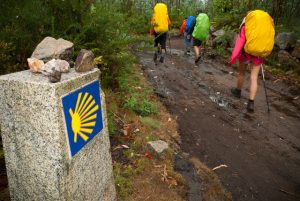
Article translated by an automatic translation system. Press here for further information.
Olveiroa to Fisterra Stage
Watch out for cyclists from Cruceiro da Armada to Camiños Chans
Information about the stage 3: Olveiroa to Fisterra Stage
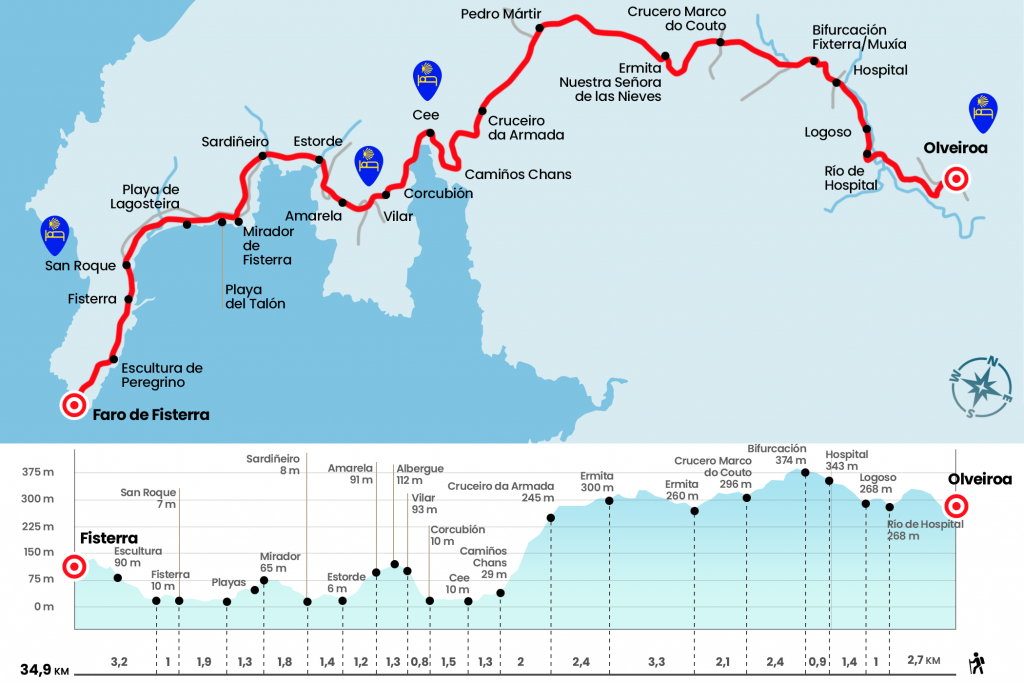
Enlarge map
Points of interest in the stage 3: Olveiroa to Fisterra Stage
The route
- Km 0. Olveiroa(Hostels. Bars)
We descend the street of the hostel and turn right to leave Olveiroa on the paved runway. Attention must be paid because in short, at the height of the Cairn 34,558, we must turn left to cross a stream and take a fitted path that leads to the Castrelo reservoir. After a curve, we take, on the right, a path that goes up a line of wind turbines. Later on we left this path and advanced along the hillside of the mountain with incredible views of the Xallas River, which flows embedded by a dense vegetation. We ended up going down to the place of Vao de Ripas, where we crossed the river Hospital by a stone bridge rehabilitated in 2005 by AGACS (Km 2.7). We saved a hill and entered Logoso, a village
located on the slopes of Monte Castelo.
- Km 3.7. Logoso(Store-Store. Bar)
We went through this small place and boarded a shuttle to the village of Hospital, where we took the road CP-3404 (Km 5.1). A few meters away there is a bar with hostel on the left.It is the last point of heating up to the Community, so you should eat something or get a drink and a snack. After the bar we cut off a bit on the old road to get to the roundabout where the cairn is located that forks the roads to Fisterra and Muxía.Check Stage 4 for the Muxía route!
- Km 6. Fisterra and Muxía
We continue on the left, in the direction of Fisterra, and past the factory we left the road on the right to take a good track surrounded by an open landscape of tojos, pines and eucalyptus. It leads us to the Marco do Couto cruise (Km 8.4), also in this place a sculpture of the monster Vákner, a myth of the middle age was placed in 2022. We continue on a similar ground, with a left-hand view of Buxantes, until the chapel of Nuestra Señora de las Nieves. There is a sinner where we can do a stop (Km 10.5).
Next, let’s go through the repopulated Monte do Lousado by comfortable slopes to the chapel of San Pedro Mártir, of the parish of Pereiriña. Manuel Vilar quotes that “the construction may be related to the monastery of Santa Tasia” (Km 13,8). We extend the walk to the Navy Cruceiro, which we can see on the right hand. From here you can see Cabo Fisterra bathed by the Atlantic (Km 16.2).
After the cruise there is a steep descent with a view to the Ría de Corcubión, which leads to Camiños Chans and Cee, where there is also an option to finish the stage thanks to the opening of several private hostels. The itinerary leads through the Camp Sacramento and rustic Magdalena to the center of Cee, where is the church of Santa Maria de Xunqueira, from the 16th century and with a Gothic chapel. Cee was populated in ancient times by the Nerios. Towards the twelfth century it was a small agricultural villa and at present it is the largest municipality on the Costa da Morte with about 8,000 inhabitants.
- Km 19.5. Community(All Services)
You can go to Corcubión taking the walk closest to the beach. There is a Jacobean cairn that diverts us from the back, but the views of the sea and the port deserve more. When you reach Corcubión you have to cross the pedestrian crossing that is located next to the Post office to link to the official route. Through San Marcos Street we reached the church of the same name. He replaced the former parish of San Andrés de Canle, is declared a Cultural Good and is a Gothic sailor style, although it has baroque and even neo-gothic parts, as is the case of the facade.
- Km 21. (All Services)
Next to the temple we take the stairs on the right and along the street of the Mercedes we go to the camp do Rollo, with playground. At this point we are going up a road that will give us pleasure with nice views of Corcubion and Cee. The climb does not end and we must use it thoroughly to overcome the short but demanding ramp that ascends to the San Roque camp, where the hostel managed by AGACS is located, and the village of Vilar (Km 21,8).
- Km 21.8. Vilar(Hostel)
Later, after crossing the road, we took a path that descends back to the AC-445. Almost always through the arcén we pass Amarela and then Estorde. At the entrance to Sardiñeiro we left a bit of the road to return to it and left it at the height of the rustic Nova.
- Km 25.7. Sardiñeiro(Bars. Store)
We say goodbye to this town for a nice stretch, which was Camino Real, where it won't be hard to see more than one hunter training the dogs. Ends in a viewpoint over Fisterra and Cabo (Km 27.5). After crossing the road again we descend suddenly to surround the Heel cove. Another short section of the road leads to Calcoba, where the extensive Langosteira Arenal springs.
- Km 28.8. Calcoba(Bar)
Many pilgrims decide to walk this stretch at the foot of the beach, a more authentic route, although the official road advances after the dunes. Fisterra is accessed in the San Roque district and passed by the Baixar Cross, a XVI granite cruise. In the obverse is Christ crucified and in the reverse Mary Immaculate with the child Jesus (Km 30,7). Santa Catalina Street is reached in Calle Real, where is the public hostel and where will give us the Fisterrana.
- Km 31.7. Fisterra(All Services)
This is not the end, we still have to climb to the Faro. After the hostel we will walk next to the chapel of Nuestra Señora del Buen Sucess, 1743 Baroque church located in Ara Solis Square. The cruise shows Christ crucified and the Virgen del Socorro. Already on the road to the Faro is the church of Santa Maria das Areas, its origin goes back to the 12th century. It houses the gothic height of the Christ of Fisterra, an image wrapped in legends. It has Puerta Santa and a 17th-century Santiago Peregrino.
The road climb is quite bearable and in the middle of the climb we will see a modern sculpture of a medieval pilgrim. The 0 kilometers' mojón welcomes us to the surroundings of the Faro. It was built in 1853 based on the design of Félix Uhagón. The entrance building is known as The Mermaid and is 1889. It houses the Tourist Information Center managed by the Neria de la Costa da Morte Association, where they give advice, sellan credentials and collect statistics (Phones: 670 29 27 20, 981 70 60 28). The prerogative peoples already worshipped the sun from this very suggestive geographical point. To see it hidden in the waters of the ocean is a unique spectacle and the punchline of a whole pilgrimage to the end of the Earth.
- Km 34.9. Faro de Fisterra
The difficulties
Remarks
In images
What to see, what to do
The hostels

¿Do you want to send any photo of "The Camino de Santiago"?
If you have any photos of "El Camino de Santiago" that you want to share with us, you can send them to us and enlarge the photo gallery
Forum: What pilgrims think about the Camino de Santiago
See all