Article translated by an automatic translation system. Press here for further information.
Stage from La Panadella to Tàrrega
The biggest difficulty is in the distance and absence of shadows at the end
Information about the stage 3: Stage from La Panadella to Tàrrega
Enlarge map
Points of interest in the stage 3: Stage from La Panadella to Tàrrega
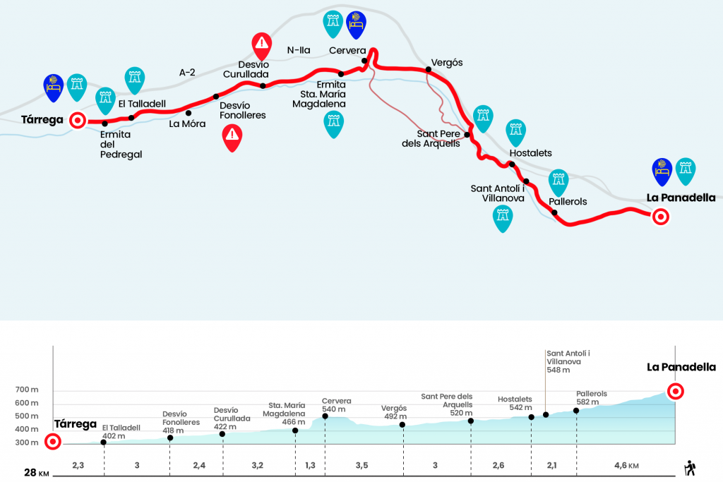
The route
Behind the gas station we crossed the parking lot to uncover the day on a road surrounded by crops and oak, pine and whipped stacks. Then, the view expands and the track progresses quickly thanks to the favorable mismatch. It's a stretch to enjoy after yesterday's road empacho. The runway dies on the road LV-2032, which we follow to the right (Km 3,4).
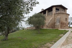
After the first hundred meters we also say goodbye to the province of Barcelona and enter Lleida through the region of La Segarra. The asphalt leads us to the visible core of Pallerols, anejo of the municipality of Talavera and situated in the valley of the Ondara River. Already in the population we momentarily leave the road and turn left onto the street of Sant Isidre to visit the Romanesque church of Sant Jaume (Km 4.6).
After the church you have to enter the street on the right, next to Cal Cardona, and return to LV-2032 until Sant Antolí i Vilanova (Km 6), provided with a small supermarket, bakery and pharmacy. On the right is the modern church of Santa Maria, 1950. After the roundabout, next to the bar l’Amistat, we entered Els Hostalets, quoted as Mesoncillos by the Italian priest Domenico Laffi in his work Voyage to Poniente. Returning from Santiago to Bologna he says that “from here we go to Cervera, distant a mare and we follow the Mesoncillos, then continuing through two leagues to Momenen, where there is a mare, and from here to Porcarises another, to reach Igualada” (Km 6,7). We crossed the village down the main street, decorated with some shell, and abandoned it after passing the church of Sant Jordi, of the 16th century. In an hornbill, we can see St. George facing the dragon. Shortly after taking the road L-203 that makes a curve to the left when leaving the village, we passed the river Ondara, affluent of the Segre, and turned to the right, detour signalized by a blue sign with the vieira that marks "Cervera", on a paved runway. It flows near the river and leads us to Sant Pere dels Arquells (Km 9,3).
The street of Sant Pere leads next to a fountain, crowned by an image of San Pedro tying the keys of Heaven. At this crossing there are up to three alternatives:
1. If we turn left hand (we will find arrows and signs a little later) we will take a section of the GR-171, which comes from the interior of Tarragona and Lleida to Cervera. It is the longest, it is 5.8 kilometers to the entrance of Cervera.
2nd. The second option, in the face of it, is most advisable in our view. Not for cyclists. Follow a hint, but soon turn left and becomes a nice path that ascends between low mountain. Acapara good views and then descend next to the ruins of the Castle of Montpaó to reach a runway. Follow it to the right to approach the bank of the river Ondara, which crosses to enter Vergós. Here it joins the second option.
3rd. The Generalitat route continues to the right through a curious estate of a neighbour that houses inside Russian fighters. It's the one we've marked in the altimetry and the distance scale. It's the simplest, but also the most boring. It goes to the N-II, which goes on the left. Its asphalt leads, passing by the Els Comtals estate, to Vergós (Km 12,3).
Its streets drag us back to the N-II, which already runs us to the gates of Cervera, a medieval city of compulsory visit. Towards the urban center we take the avenues of Igualada and Catalonia to turn left by General Güell. We always head out onto Calle Mayor. In the carrer Sabater, one of the streets we find on the right hand, is the Colegio Residencia de la Sagrada Familia. (km 15.8)
From the narrow carrer de Sabater we access Calle Mayor, which we follow to the right. It ends in Plaza Mayor, where we see the City Hall of the capital of the Segarra and the Church of Santa Maria's fine octagonal tower. It is worth stopping under the balconies of the Casa Consistorial and observing the carved figures that support them. We continue down the street and plaza of Sant Domingo, on the right of the City Hall, and turn right down the carrer and plaza Sant Magi (note that this turn may be missignalized). We reached the L-214 highway, which we followed on the left, down to the ruins of the chapel of Santa Maria Magdalena. At the time there was an attached hospital for lepers served by nuns (Km 17.1).
Next to the church we must leave the road and turn right, where a wide track is born that progresses between lunar hills and the green crops of the Ondara. We have to be patient because the landscape will not change the slightest in a couple of hours and, in addition, the shadow is sold face in these places. Until Tàrrega we will always move forward, without deviating even once. A debugger, several masías and some palleses break the symmetrical scheme drawn by the greens and ochres.
We passed the diversion to the nucleus of the Curullada (Km 20,3), dependent nucleus of Granyanella, and twenty minutes later the crossing to the Torre Saportella, manor house fallen in oblivion that rises to the right (Km 21,7). Two kilometers and four hundred meters later we do the same with the crossing of Fonolleres, on a teso and dominated by its castle (Km 22,7) and we arrived next to a scale and the diversion to La Mora (Km 23,5).
We continue in front and enter Talladell by Calle Mayor (Km 25.7). This population was annexed to Tàrrega in 1969 and is the first of the Urgell region to visit this Jacobean itinerary. At the exit we see the restored hermitage of the Pedregal, near the place that occupied the abbey of Cistercian nuns Santa María del Pedregal, founded in the 12th century and that had a hospital. From the front, on Avenida de la Generalitat, we entered Tàrrega, ending in Plaza del Carme, popularly known as ‘el Pati’. Here is the Catalan Way through Lleida and Zaragoza, which is ahead of the street, with that of San Juan de la Peña, which we follow in this guide and which continues on the right.(Km 28).
The difficulties
Remarks
In images
What to see, what to do
The hostels

¿Do you want to send any photo of "The Camino de Santiago"?
If you have any photos of "El Camino de Santiago" that you want to share with us, you can send them to us and enlarge the photo gallery
Forum: What pilgrims think about the Camino de Santiago
See all