Article translated by an automatic translation system. Press here for further information.
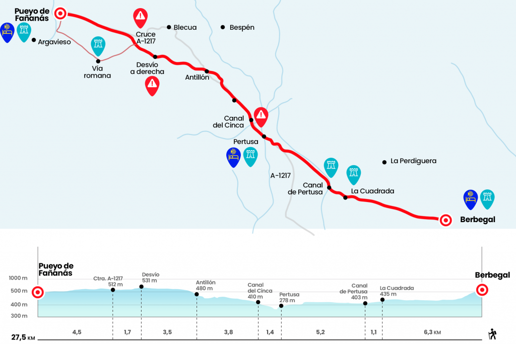
Stage from Berbegal to Pueyo de Fañanas
Long day, but life saving if we sleep in Pertusa or Antillón literas
Information about the stage 9: Stage from Berbegal to Pueyo de Fañanas
Enlarge map
Points of interest in the stage 9: Stage from Berbegal to Pueyo de Fañanas
The route
From the hostel of Berbegal you have to go back to the bar Meridiano, in Plaza España opposite Santa María la Blanca. In front of the bar we take Calle La Iglesia, the mouthpiece of the left. At the end of this rustic we turn 90º to the left by a section of cement to get down to the road and continue in front of the yellow arrows and GR-45 signals that indicate La Perdiguera. A stony path descends from the altozano, leaving a livestock vessel on the right hand and passes under the electrical line. The course that we will follow to the Square seems to be drawn by a delinquent, because if we look at the front we will distinguish the white set of La Quadada, which from here hardly seems to lift a palm from the ground. Chasing our shadow and looking back to see an interesting Berbegal contrallusion, we advanced down the almost naked road, only dressed by some almonds, and delighted with deep panoramic views. In a V-bifurcation, we follow the path of the left, as we go forward.(Km 2.5)
Already in the last section, the road tends to be erased and becomes rounds that we follow without difficulty, already with the view set in the first objective:The square, tiny population of Torres de Alcanadre, and the last of the Somontano de Barbastro that crosses the Camino de Santiago. In the vicinity there are still some corrals that gave refuge to the cattle of the canyon that linked Mequinenza and the pirenaico Broto valley. We enter Berbegal Street and turn right onto the major street, which ends in a rest area where it would be a sin not to stop. The roof and fountain are 10 (Km 6,3).
We turn left as soon as we pass the cruise to take the track leading to the Pertusa canal, a work derived from the Cinca canal (Km 7.4). We cross the canal and continue on the right, accompanying his course on the service track, flanked by junkies. At 2.3 kilometers the canal travels hidden (Km 9.7) and we still advance 1.3 kilometers further along the paved runway. Before the sign of forbidden passage, we left the canal company to go to the road A-1217. We follow her right to the gates of Pertusa, safe passage of the Roman road Ilerda – Osca and hugged by a meander of the river Alcanadre, a perfect model of oppidum. We leave the A-1217 by the left wing to enter next to some wineries excavated and access the core by Calle La Tallada.Pertusa is the first town in La Hoya de Huesca on the Camino (Km 12,6).
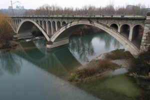
The exempt hexagonal tower built in 1578 must not be lost inside the village. It is attributed to Juan de Herrera (El Escorial, Aranjuez, etc.) or one of the architects of your school. It also deserves the Romanesque crypt placed under the altar of the Baroque church of Santa Maria, and as you cannot miss the bar of the town that is located near the church of Santa Maria. From the playground we go down a few stairs to the bridge of the highway over the Alcanadre, tributary of the Cinca. Downstream waters still survive the ends of a formidable Roman bridge that allowed the passage of the road. Upstream the aqueduct of the Cinca canal flies. As soon as we pass the bridge, we go up to the right on a rocky road between mounds of clay and sandstone. It is a shortcut that avoids several A-1217 horseshoe curves. We went out to her and followed her on the right. Now comes a good road section with a testimonial arcén. Soon, before kilometric point 25, we passed over the Cinca canal, a 90-kilometer hydraulic construction run by the powerful reservoirs of the Medium and El Grado, (Km 14)
Seedlings and sandstone shells drive the road. We leave it on the right shoulder before reaching kilometric point 22, through a hidden middle path between carrascas. Right at that point, across the road, is the cemetery. Apart from the omnipresent arrows, we will also see the Jacobean stakes placed by the Hoya de Huesca in its plan of tourist dynamization. The road advances to Antillón, haughty over another teso and still custodian of several towers of the medieval wall, which defended the neighborhood with the relief of the natural palisade that formed the dwellings. The road delegates to a paved runway that goes up to the road and revives the resonance. If we have some time it is advisable to go to the top and see the towers of Casa Cebollero and the Prison, as well as enjoy the Pyrenean views and the Hoya that gives us a viewpoint. Something closer is the church of the Nativity, with Romanesque vestiges on the tower and on the front cover, the almazara and the bread oven. On a side of the City Hall there is a social bar, with Internet connection, where neighbors have kindly enabled a couple of beds to stay overnight. If it is closed ask about José María.(km 17,8)
Then we left the road in Antillón, next to the p.k. 21, to climb the cabanera of San Juan, a paved track that passes under the hermitage of San Juan, of the 18th century. We face a stony balcony, flanked by almonds and some agricultural constructions that dominates from the nearby town of Blecua and the Hormiga ravine to the Sierra and Cañones de Guara, with the three Pyrenean Sorores pulling their heads to the bottom of the post. It is a part to enjoy, also with some cherry trees and some carrasch stains guiding the march, after the unusual asphalt empacho we brought from the Pertusa canal. 3.5 kilometers from Antillón, pay attention! , there is a fork and we turn the way to the right, not a steep trot that makes a 90-degree turn to the right (there is a yellow arrow that seems to confuse the pilgrims), but a little later a track that also leaves to the right after the trees and then turns left to a pig farm. (Km 21.3) We go down to receive soon the smell of a raft of purines, next to a pig farm, and we give to another track that we follow on the right to at 200 meters later turn left (Km 22.6).
At this point you have to decide whether to take this new track (via Roman) or continue forward to the A-1217, which is 400 meters later. The road option, which has stopped signalling, although no loss allowed, saves 1.5 kilometers, but involves almost 4.5 kilometers of asphalt with several slides to Pueyo de Fañanas. If we deviate along the runway, marked in spring 2012 with yellow arrows and entering the Roman road route, we will take 20 more minutes, but we will avoid exposing ourselves to traffic (this alternative is marked in red on the stage map, although the profile and total distance of 27.5 km refer to the road option).We choose to take the road, although we have to pay attention because the signs as a pilgrim tells us are insufficient, which passes under the electric line and continues straight. We always go forward for 2.3 kilometers until we reach the junction with the royal cast of Antillón to Huerto, unmasked by the sign of ‘Vía Romana’ (Km 24,9).
Here we take the right path, which is surrounded by carrascas. It's the real casting, where we're already moving forward without taking any detours. At 2.1 kilometers we went by a farm to the left hand and then another to the right hand, after the latter we continued straight at the crossing to get down to the acequia of the Lacunas and the Guatizalema River, point by which the Roman road from Ilerda to Osca flowed. One hundred and fifty meters before we reach the river right where there is a raft we turn 90° to the right (Km 27,9) and we are approaching Pueyo de Fañanas from the south. A single street leads us to the plaza, where is the social bar and the hostel, it is advisable to call in advance to the hostel for availability, see observations, just above (Km 29).
The difficulties
Remarks
In images
What to see, what to do
The hostels

¿Do you want to send any photo of "The Camino de Santiago"?
If you have any photos of "El Camino de Santiago" that you want to share with us, you can send them to us and enlarge the photo gallery

Forum: What pilgrims think about the Camino de Santiago
See all