Article translated by an automatic translation system. Press here for further information.
Municipality of Huesca to Huesca
Huesca is the first large city from Montserrat
Information about the stage 10: Municipality of Huesca to Huesca
Enlarge map
Points of interest in the stage 10: Municipality of Huesca to Huesca
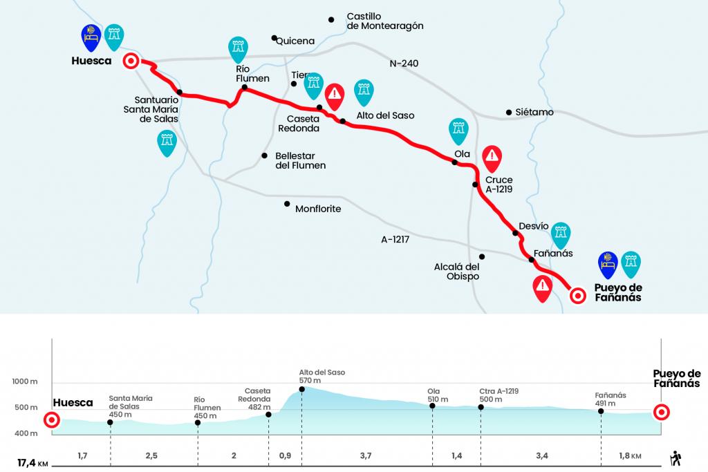
The route
We fold right by the street next to the church and go to the A-1217 road. You have to follow it on the left to Phannas. This population is also from the municipality of Alcalá del Obispo, where more than half of the journey of this tenth stage will take place. Before arriving we cross the river Guatizalema, coming from the municipality of Sabiñánigo and providing its flow to the river Alcanadre (km 1.1). Then we see the magnificent bearing of the church of St. John the Baptist, of the 16th century and raised on a fortification. We leave the road to enter Fañannas on the avenue of Bureta (marquesina), which leads us to Plaza Mayor A coat of arms dated in 1781 adorns one of the houses (km 1.8).
In the plaza we turn left and go out the La Paz calla always front, a paved road between houses and gardens that reverts on a dirt road through which we leave the population. About 600 meters in a straight line, far from the road to the right, is the chapel of Bureta, restored in 2001 and inherited from a 12th century hospital. Attached to the hermitage is the Santero's house. At 1.4 kilometers from the center of Fañannas (Km 3.2), we arrived at a fork. You have to get out of the way on the left, on a scab of water scarred stone. Several arrows and a measured stake help us distinguish it. This path, with some pools of the acequias of Abrisén and the Molino, leads to the A-1219 highway (Km 5.2), which we follow at the right hand a little more than half a kilometer to the Ola crossing where we will turn left to that population, which remains 700 meters according to the sign indicating the road.
After the Bottle River we enter this alkaline population of just two dozen neighbors. The Camino does not pass through the church square, but it can be accessed under an arch. It has a perfect fountain and several banks for the first bite. The wave gives off a timeless halo. The parish of Santa Cruz is in the 17th century and the stone houses of past centuries abound with their shield on the dintel (Km 6,6).
We leave Ola passing the "Ola Cross" through a paved runway that becomes dirt. Some livestock vessels with their silos on the left hand and a watering hole protrude between cultivation plots and carrascals. We're gaining some height, leaving to the right access to another spacecraft, and then passing by next to Montori's broom, a brick and stone half-plummeted. We then crowned the Saso to get the first great panorama of Huesca. Until the hostel of the capital there are still 7 kilometers (Km 10.3). On the hill there is a forest surveillance tower and it is distinguished to the bottom, on the right hand, the Castle of Montearagón, fortification that ordered the construction of Sancho Ramírez in 1086 as a line of advancement in the conquest of Huesca. The Camino de Santiago descends from Saso through the Trincheras Route, a small trail (PR-HU-144) that owes its name to the Civil War trench line with underground galleries and machine-gun nests.
The downfall entails some difficulty, especially with water and mud due to the risk of slips. Cyclists will have to get ground. The ground below continues uneven by the passage of torrenteras and our itinerary passes by the round house, located on the left hand side. A guardaviñas that in addition to guarding the crops served as a toll point of the Cañada Real (Km 11,2). We continued from the front passing the diversion to Tierz, toponnimo from the term Latin viary Tertium Milliarium, another reference to the passage of the Roman road linking Lleida and Huesca and continuing to Zaragoza. Those who want to stop can divert half a kilometre to the population of Tierz to return in the same way. We cross the road between Bellestar del Flumen and Tierz and move straight forward as an arrow until the passage over the river Flumen (Km 13,2).
After crossing, we turn 90º left towards the Chapel of Salas. A narrow path runs along the riverbank (in a weekday full of walkers) for a kilometer and at one point we turn right to take the path that leads to the orchards of Almériz or Salas. Twenty minutes later, after an equestrian, we crossed the Isole River to access the Shrine of Santa Maria de Salas. National Monument since 1951, was modified in the 18th century in baroque style. In 1250 Jaime I the Conqueror signed a “Privilege of Protection and Safeguarding” for all those pilgrims who went through this Shrine. From this place comes a thirteenth century pilgrimage, a sheet or medal of lead as a seal that the pilgrims gathered in the places they visited and that, sewn in their clothes, accredited their passage (Km 15,7).
Next to the electric tower in front of the shrine there is the possibility to follow from front to Huesca or turn right to go direct to the pilgrim hospital San Galindo, name in memory of the hospital pilgrim who is buried in Salas. It leaves on the right and is marked with yellow arrows and the letters H P, Hospital de Peregrinos, on a paved road that always leads to a STOP that is at the junction of that round with Balsas de Chirin street, on the STOP we turn right, we follow in front of the roundabout and we deviate by the first mouthpiece of the left (streets of Our Lady). In number 34 is the pilgrim hostel San Galindo (Km 17.4).
The difficulties
Remarks
In images
What to see, what to do
The hostels

¿Do you want to send any photo of "The Camino de Santiago"?
If you have any photos of "El Camino de Santiago" that you want to share with us, you can send them to us and enlarge the photo gallery

Forum: What pilgrims think about the Camino de Santiago
See all