Article translated by an automatic translation system. Press here for further information.
Montserrat to Igualada Stage
Two weeks walk to stand in front of us with San Juan de la Peña
Information about the stage 1: Montserrat to Igualada Stage
Enlarge map
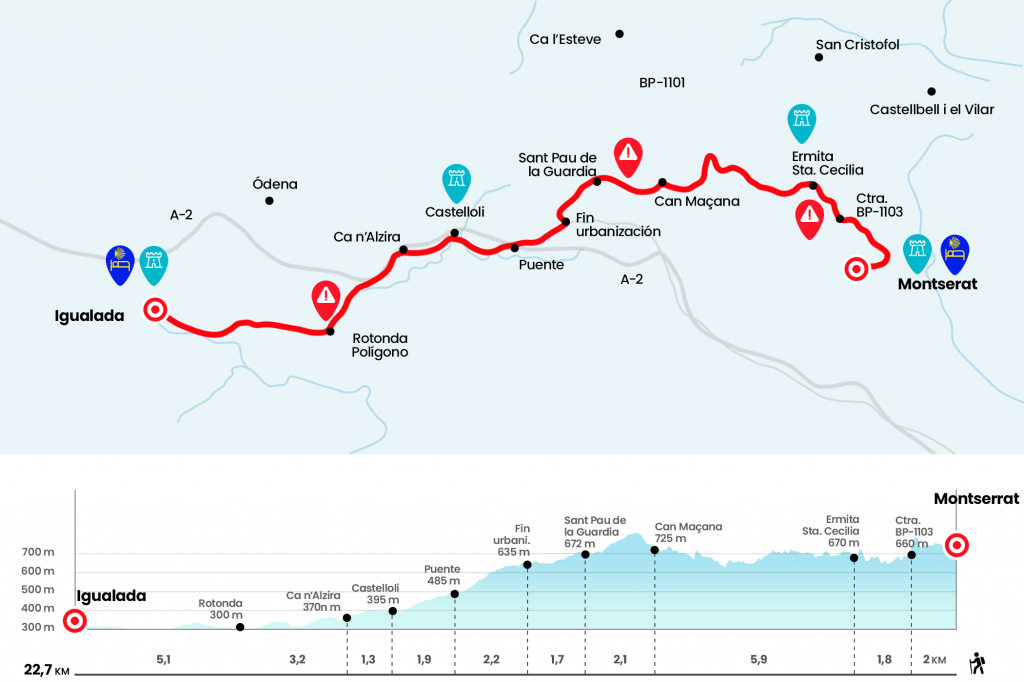
Points of interest in the stage 1: Montserrat to Igualada Stage
The route
All a luxury to sleep in the pilgrims' hostel of Nuestra Señora, at 727 meters altitude, next to the Benedictine monastery that shelters the Moreneta and under the Calcareous moles and capricious silhouette that form the Natural Park of Montserrat. The exit was not conveniently marked so we detailed the itinerary to follow: we went by the Abat Cisneros Hostel, we went through the Plaza de Santa Maria and we went down the stairs next to the facade of the hostel. Behind them we continue to the left, passing by the Botiga and the cafeteria, and we move straight towards the parking lot. In front of the building of the Mirador dels Apostols you have to take the road signalized as Camí dels Degotalls and Camí de Sant Jaume (Km 0.6). (There is also the possibility of taking away the kilometres of road from the monastery to Can Maçana following the indications of the GR-172 that from the monastery progresses without dangers to a higher level than the road and travelling virtually the same distance)
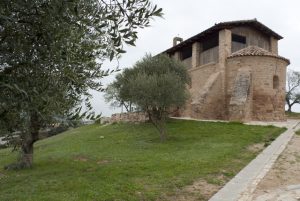
The first contact with the Catalan Way is a nice walk between Mediterranean and even Atlantic vegetation and always adorned by endless tiles decorated with Marian images. At the height of the image of Santa Maria de les esglesies de Sant Pere de Terrassa (Km 1,5), one must deviate to the right by a narrow path closed by the shrubland. Quickly go down to the BP-1103 (Km 2) road, located at 660 meters altitude. It is the road that will drive us to Can Maçana. Notice, we follow it to the left. Although we see yellow arrows in the opposite direction (mostly painted in the chipping) there is no need to worry because they signal the rise to Montserrat, a place of pilgrimage par excellence in Catalonia. Always by asphalt we leave behind kilometric points 7 and 6 to reach by the chapel of Santa Cecilia, from the middle of the 10th century and visibly Romanesque invoice. Until 1954 a community of Benedictine nuns resided here and next to the temple is the refuge of Santa Cecilia, owned by the Federation of Hiking Entities of Catalonia. The complex corresponds to the municipality of Marganell, in the region of Bages (Km 3.8).
Near the hermitage there is an indicator pole that points to access to the GR-172, a path that also leads to Can Maçana. The route of this GR advances on the road and is a much more demanding alternative than the official route of the Catalan Way, which continues through the asphalt. We continue along the arcén of the BP-1103 and admiring the rounded peaks and the coastline of the Natural Park. After the kilometric point 2 we set aside the rest area of the Malniu (Km 7,8). Only a couple of kilometers to the coll of Can Maçana, where is the old sale also known as Casa Martí. At the crossroads we continue to the left, towards Barcelona – Lleida. At your side there is a perfect catcher for the first stop of the day (Km 9.7).
We briefly retake the arcén of the road and at 50 meters an indicator post of the Camí de Sant Jaume (brand 2 km to Sant Pau de la Guàrdia) invites us to leave the asphalt on the right. So we got into a fleeting stony path that exceeds a 60-meter slope. The effort is not prolonged, although you almost have to climb, and at the top you get a comforting panorama of Can Maçana and the conglomerate rock needles. On the high we leave the limits of the Montserrat Mountain Natural Park (Km 10.4). Monte abundantly in pine, juniper and hezo accompanies us on the descent to Sant Pau de la Guàrdia, a population belonging to the municipality of El Bruc (Catalan heather). We went next to the church of St. Paul in the 18th century, and next to the restaurant and hotel El Celler de la Guàrdia (Km 11,8).
We leave Sant Pau and go ahead at a crossroads (the blue indicator of the Camí de Sant Jaume marks 6 km to Castellolí) to enter the Montserrat Parc Urbanization. We cross it and surround it for more than a kilometer on Verge de Montserrat Street and finally turn right onto Castellolí Street (Km 13,5). After urbanization we continue between pines and open field until we take a path surrounded by rape. Before a fire surveillance turret the Camí de Sant Jaume disconnects from the GR-172 on the right. So we got to N-IIa, the oldest version of N-II. We descend through it and leave it on the right after the first curve. The diversion is well marked (it is 3.7 km to Castellolí) and soon we take a forest path that goes to our right. This section is pleasant and unfortunately ends up dying on the road, which leads us to cross the bridge over the A-2 or Northeast motorway (Km 15,7). On a dirt road and then paved we advanced parallel to the A-2 to Castellolí. In this population there is already a municipal hostel that welcomes pilgrims (see section observations and list of hostels of the stage) (Km 17,6).
We cross the nucleus through Avenida de la Unión, where we will find several bars that offer a menu of the day. At the end of the population, on our right is the modern church of Sant Vicenç, heir to the temple of the 18th century that still survives on a nearby hill. By asphalt, between the A-2 and cereal crops, we approach Ca n’Alzina, the Houses of Alsina (Km 18.9) After a fountain, located under the road, we reach the N-IIa, we take it to the left soon after taking another paved runway that goes up the right (indicates 4.7 km to Igualada). A masía restaurant and the bridge over the highway, which we cross to the right are the next milestones. Then we met Casa Pala and saved the highway again this time to the left. We continued to save below the C-37 motorway to reach a roundabout of the industrial estate Pla de les Gavarres.(km 22.1)
We entered Igualada next to the endless industrial estate Pla de les Gavarres. Patience because there are still 5 kilometers to the hostel of the capital of Anoia. After a gas station, the official route is separated from the N-IIa by the left and takes the C-244. Towards the center and the hostel, we cross without loss the avenue of Montserrat (crossing the roads of the vicinity), the avenue of Caresmar and the street of the Soledat to reach the plaza of Rei, very close to the promenade of Sant Isidre, commercial artery and vital center of Igualada. Towards the hostel we continue in front of Calle Sant Bartomeu and at the bottom we take some stairs that are born to the right. After a long alley, we turn right onto the street of Sant Miquel, a medieval passage that was inside the walled enclosure, which places us on the side of the superb church of Santa Maria, of the seventeenth century, although restored at the end of the twentieth century. From the temple we come to the town hall square. Then, from the front, through the commercial artery of L’Argent, calle de Sant Simplici and the plaza de Sant Joan, which gives way to the street of Sant Agustí and later to the avenue d’Angel Guimará. Just to the right of the gas station is Prat de la Riba Street. On number 47 is the hostel (attention because the hostel is temporarily closed, check availability by phone, note 2022) (Km 27.2).
The difficulties
Remarks
In images
What to see, what to do
The hostels

¿Do you want to send any photo of "The Camino de Santiago"?
If you have any photos of "El Camino de Santiago" that you want to share with us, you can send them to us and enlarge the photo gallery
Forum: What pilgrims think about the Camino de Santiago
See all