Article translated by an automatic translation system. Press here for further information.
La Panadella Match Stage
An anodine stretch that extends for 22 kilometers to La Panadella
Information about the stage 2: La Panadella Match Stage
Enlarge map
Points of interest in the stage 2: La Panadella Match Stage
The route
We start from the Plaza del Bruc in front of the Basilica of Santa Maria, continue along the streets L'Argent, Sant Simplici and Sant Agustí to finally leave Igualada by the avenue of Angel Guimará, later, after the roundabout near the bridge over the river Anoia, we will continue forward. At about 250 meters we turn right onto the avenue of Emili Vallés, passing next to the nursery El Espígol and several institutes. The official signs indicate 37.5 kilometers to Cervera, which he announced at the entrance to Igualada. Incomprehensible. By Calle de Miquel Jordana í Puig and Calle l’Empordá we finally reached the Romanesque chapel of Sant Jaume Sesoliveres, first mentioned in 1059 and restored between 1993 and 1995 (km 2.1).
We resumed the march on the street of La Ermita, turned right by the Bagés, then left by l’Alt Camp and right by the avenue of Sant Jaume Ses Oliveres. The maze continues to the left by Penedés Street, then to the right by Solsones and finally to the left by Can Blasi Road. After a landfall, inhabited by the closing convent of Carmen, we descend by the Can Blasi farmhouse at the foot of the road. An excerpt about asphalt and the later tan colorado separated us from Sant Genís, a locality that belongs to the municipality of Jorba and that we approach through Calle Mayor (Km 4.9).
Leaving the church on the left we left this village and took the Colorado tartan from the access road to the N-II. In this section, on the left hand side is the diversion to the Romanesque chapel of Santa Maria de la Sala (Km 5.5). After passing a football field we go down to the foot of the N-II to enter Jorba, service population where you can take a snack. We can cross the population by the road, by Canaletes Avenue or, on the contrary, and more recommendable, by the main nucleus, where is the parish church of Sant Pere, of the XVI (Km 6.5).
Here also emerges the castle ruins, destroyed in 1840 during the First Carlist War. We can take a license and go up, but the prize will not be the Castle and it will be the fabulous panorama of Jorba and its surroundings. We left the village by the N-IIa, a few meters from the hostel and the chapel of Sant Jaume, saving above the highway and later the stream of the river Clariana, affluent of Anoia. The day continues to drag its monotony and a few six hundred meters after the petrol station and the hostel of Ganxo we went under the highway (Km 11,4).
The slope starts to be patent and we link to the N-II path, which at a point we left on the right to continue along a tartan track where a blue indication with the vieira tells us Santa María del Camí 1 km, although we can also go ahead by the tartan lane. We went by a few houses (on the maps like El Simón) and after a short rodeo we reached Santa María del Camí, in the municipality of Veciana. On the other side of the road is the Romanesque hermitage, of a single nave and provided in the apse by a window formed by radial candles. In 1919 the church was built next door and the Romanesque was closed to worship (Km 14.4).
Some helpful photos of the apse, window and coat of arms of Santa Cecilia de Montserrat, of which was Priorato, posed on the northern front and the stage insists on more of the same. We passed the p.k. 539 and after a slide we visited Porquerisses: twenty houses of the municipality of Argençola and the sober church of Sant Genís (Km 17). At the exit, instead of recovering the asphalt machacón, we continue on a left hand track until soon after we see painted on a tree another yellow arrow that tells us to turn back to the left, if we continue straight we will go to the road which we will take to the left, if we turn on the runway where the yellow arrow to the left we will take a path with some weed to the edge of the tiny here river Anoia. The odyssey ends fast and returns us to the edge of the road equally (Km 18,6).
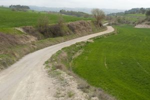
We are already skipping one by one the kilometres, long and heavy, by the way, that remain until the port of Panadella is finished. This raval of the core of Montmaneu is a must stop at the edge of the missing Camino Real. Despite the highway it survives very dignibly, as the hostel, restaurants and the two gas stations continue with its frantic activity. Truckers, travellers, tourists and pilgrims continue to date in the Panadella (Km 22).
The difficulties
Remarks
In images
What to see, what to do
The hostels

¿Do you want to send any photo of "The Camino de Santiago"?
If you have any photos of "El Camino de Santiago" that you want to share with us, you can send them to us and enlarge the photo gallery
Forum: What pilgrims think about the Camino de Santiago
See all