Article translated by an automatic translation system. Press here for further information.
Huesca to Bolea Stage
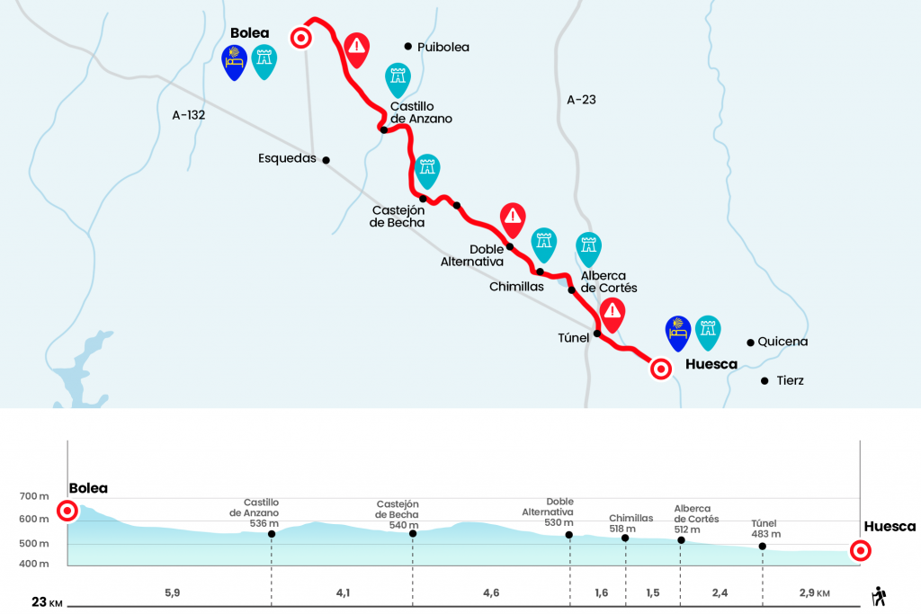
The hard part is the access to Bolea by the climb in the last kilometer
Information about the stage 11: Huesca to Bolea Stage
Enlarge map
Points of interest in the stage 11: Huesca to Bolea Stage
The route
The first arrow guides the front door of the Pilgrim Hospital through the street of Brother Martin Coronas. We crossed the two lanes of Ramon and Cajal's Walk and entered the street of Velódromo, which was born next to the Hospital of the Sacred Heart of Jesus. It ends on the promenade of Lucas Mallada, always parallel to the river Isole. We no longer abandon this artery attached to the stream, following from the front in a roundabout (we can find some yellow arrows in the curbs of the walk) and next to several gardens. On the left we will see the line of the wall, in the round of Montearagón, and then the convent of the Miguelas. A few hundred meters after the roundabout of the N-330, right across the river, we descend to the right by stairs to the paved road of La Cruz del Palmo (Km 1,8).
Straight, and at the exit of a tunnel under the Mudéjar A-23 motorway, we turn 90º to the right (Km 2,9). We accompanied his parallel course to the highway by a runway for 550 meters and then we walked left. The path of Chimillas, which follows and crosses the course of several acequias, leads us forward to the pool of Cortés or Chimillas, a pond for irrigation built in 1501 under the Order of St. John of Jerusalem and which gives origin to the Major of Cortés and Algüerdia (Km 5.3). It can be surrounded by both shores. On the left, it's shorter and gloomy, and on the right, although it does something more back, it's easier and we'll see some more informative panel on the raft fauna. We close the entire perimeter and pass by the Residence of the 3rd age Sierra de Guara, with cafeteria and restaurant. Then we enter Chimillas, of probable Muslim origin, next to the City Hall and the church of St. George. The temple is in the 17th century with a large polychrome altarpiece from the Oscense convent of the Carmelites (Km 6,8).
A few meters, on the left hand, behind the plaza is the bar La Alberca, which opens every day. It should be provided because until Bolea there are 16.2 kilometres (according to our calculations) and no population, only a couple of farms. We passed through the village facing the roundabout. A whitish runway awaits us. At 100 meters we continue on the right and we go later next to the finca Kabbalero (Km 8). At 250 meters, at the next fork, back to the right. The bifurcation that comes 200 meters later raises two options: on the left, painted with arrows, is shorter, but with some vericutes; on the right is marked with Jacobean stakes that put the Hoya de Huesca, more suitable for bicycles and easier to follow (Km 8.4).
We count the option on the left, which is reflected in the map. First of all, we do not deviate, following a sometimes stony path that leads us to cross a cereal field. It is placed in a carrascal and we line a sown on the right, accessing a thicker area of carrascas, but with a clear outline, which leads to a raft stuck with frogs (Km 11,2). We leave it on the right bank and we reach a track (the option on the right links here), which comes down in front of an already clear panorama. We approach Castejón de Becha or Castel de Castejón, with his house and the Romanesque chapel of San Miguel, of the 13th century. Becha is an agricultural property, also known in this area by the name of castles, the term of Esqueda and the municipality of La Sotonera. Before entering we go by a raft, with the Gratal peak at the bottom, of over 1,500 meters (Km 13).
We surrounded the property, leaving the hermitage to the left. We leave north and the trail draws an impressive line of several kilometers, passing a ship that can serve as a shed at any given time. About 300 meters later we continue on the left, drawing a curve to the west facing the next location:Castle of Anzano. We entered this estate, also from Esmantos and La Sotonera, passing the River Arria. The building is an amalgam, a kind of fortification that most looks like the containment wall of some reservoir. In bricks coated, the most notable is its cornice and the series of arches. She was reportedly sent to build one of her owners in the 1500 (Km 17.1).
At 90 meters, outside the left road, there is a possible living room and the 13th century Romanesque church. There is a complete report of this set on the full website of Antonio García Omedes on the Aragonese Romanesque. But the itinerary leaves the finca next to the house, leaving on the right. At 550 meters from Anzano we turn 90º to take the track on the left. Always head around a huge cultivable plain protected by the External Mountain Range of Chivalry and Gratal. You pass the river Salado, of uncertain flow, where there is usually a herd of cows (Km 19.5) and 1.3 kilometers later, next to the stream of the Fontvaleria canyon, we turn right.
A road goes up to Bolea, the town with a cherry taste, on a hill, like the Berbegal of past days. The former collegiate of Santa Maria la Mayor stands out, raised between 1541 and 1559 on the 12th century Romanesque temple. We access the urban area next to a fountain, located in the right place, and continue the last steps along the street of the Fuente, where is the Baroque church of St. Thomas and Our Lady of Solitude. Here we turn left onto Paraíso Street and then on the right we reach Plaza Mayor.
The head of the municipal hostel is Javier, whom we will be able to locate on the phone 722 827 397. The accommodation is located below, just outside the village on the sports courts (Km 23).
The difficulties
Remarks
In images
What to see, what to do
The hostels

¿Do you want to send any photo of "The Camino de Santiago"?
If you have any photos of "El Camino de Santiago" that you want to share with us, you can send them to us and enlarge the photo gallery


Forum: What pilgrims think about the Camino de Santiago
See all