Article translated by an automatic translation system. Press here for further information.
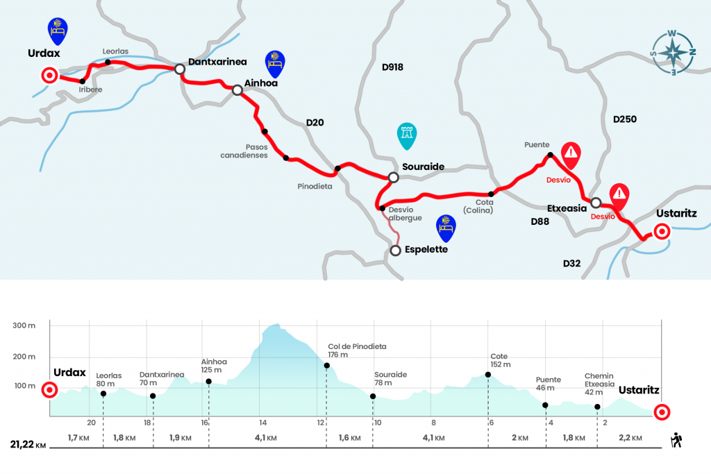
Ustaritz to Urdax
The first 13.5 km from Ustaritz are known as "icebreakers"
Information about the stage 2: Ustaritz to Urdax
Enlarge map
The route
- Km 0. Ustaritz(Hostel, Cottage. Bars. Shops. Pharmacy. ATM)
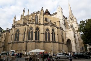
After the church we are still in front about 300 meters to the Place de la Mairie, where we say goodbye to the Jacobean path going towards Saint Jean Pied de Port. We take the Via de Baztán by Rue Ferrondoa next to a beautiful typical house. Dated 1570, its white walls contrast with the ridges and beams painted in red, wearing naked parts of the sillares. After it we turn right onto Rue du Lavoir and, after passing the shopping area, we climb stairs that lead to the cemetery surrounding it. Right after that we go to the right by Côté Dorréa. On the rise, as soon as the curve passes, we continue to the left by Chemin Saint Michel. We go to the D88 highway, we pass the chapel of San Miguel and, listen!, we go through the right wing so we don't miss the posterior detour that is on that side of the road and enters a wooded area. Many pilgrims do not see it and are still lost on the road (Km 1,4).
The road goes down to the D250, which we follow up to a roundabout to climb left by Chemin Etxeasia (Km 2.2). We go through the urbanization, follow the neighborhood trail and, pay attention, because at about 350 meters comes the second conflicting point of the stage. You have to open a portillo in the second left-hand diversion, where a sign of the Baztanés Road nestled in an old oak is usually hidden between the branches (Km 3,3). Thus we enter a nice robles and chestnuts, very prone to embark upon the presence of countless streams. Five minutes later, we ran a portillo over a regatta and 300 meters later crossed another one over a wooden bridge. Suddenly we are at a crossroads and continue down the left, discarding the one that follows from the front (Km 4).
The mud persists next to the water courses, but we soon leave the shelter of the trees and move along a gravel trail between meadows. Soon we came across the D88, which we crossed to go forward and reach a small height (Km 6). The Espelette pepper crops, which in France have a Controlled Designation of Origin, are already dyed some plots, not for nothing is the star product of the area, deeply rooted in popular cuisine and culture. The track, wide, is descending in wide panoramic without startles. Two kilometers after the top, the track rotates right and passes through several scattered neighborhoods. Just before going to the D918, a sign tells us the diversion to the picturesque Espelette (left hand). OJO, Espelette hostel is closed.
- Km 9.Optional diversion to Espelette (All services)
A little over a kilometer without taking the diversion to Espelette we reached the D918, we moved right to Souraide for another kilometer. Before reaching the central roundabout, where the church of Santiago is located, the Baztanés Road leaves the road on the left by the Chemin de Txapitela. However, we recommend progressing a few meters to visit the town and church and take a break. It has a size of the pilgrim apostle in the major altarpiece and several steles and tombstones in the atrium. In addition, right at the entrance, we can override the credential with a nice stamp with the temple stamp and the cross of Santiago along with the bourbon and the vieira.
- Km 10.1. Souraide(Bar. Store)
Again at the Chemin de Txapitela we progress in a strong ascent and, after passing the first home, we turn right by Chemin d’Apxenea. This paved runway goes up to the Col de Pinodieta, at the same D20 (Km 11,7). Notice, we have to cross the road and go ahead, we will see a sticker of the Baztan Way. We followed the track for 200 meters and turned on the first detour to the right. A clear stretch is now taking place along the hillside of Mount Erebi, with excellent views of this historic area of the Labort. At the bottom, on the right hand, you can see the repeater of Mount La Rhune, at the same border at 905 meters altitude, very visited thanks to the zipper train that rises from the Col de Saint-Ignace, in Sare. We go down the main road, taking a Canadian step, and then we go down under trees, with another step, to the entrance of Ainhoa, a small postal population, very touristic. We head to the center, next to the church of Nuestra Señora de la Asunción, of the 13th century, surrounded by the holy field, where several discoidal steles are seen.
- Km 15.8. Ainhoa(Hostel. Bars. Shops. Tourist Office)
We cross this road village through the main street, small shops and coincident with the D20. Notice, because we soon left right at Atelier Sculptures. We go down to a parking lot and then turn right onto Auzoa Amikueta. In the next bifurcation, we go left, down. Paying attention to the crossings we finally present ourselves in the neighborhood of Dantxaria, belonging to Ainhoa and the last French nucleus a few meters from entering Spain. His name comes from the dantzari and whale fisherman Joannes de Quirno, who built several houses here. One of them, from 1733, is on the right hand by the Camino. Under one of the windows you can read an inscription with his name and that of his wife Joana. In the dintel a shield with a cross and two cetaceans. We entered Spain passing the old customs and the Lapitxuri regatta, tax of the Nivelle .
- Km 17.7. Dantxarinea(Hostels. Casas Rurales. Bars. Shops. Pharmacy. ATM)
We are already in Dantxarinea, a neighborhood of Urdax that has been based for generations on trade. His border status has filled him with endless sales, restaurants and gas stations, where our French neighbours mostly come. It can be used to raise money because there is no cashier in Urdax. We cross Dantxarinea at the foot of the N-121-B road and in a roundabout we receive a beautiful reddish sandstone, exit from the Baztan’s entrails. The size, 2005 and work of Cesáreo Soulé, shows the silhouette of Navarra with the route of the Camino. By the way, welcome are our beloved yellow arrows. A little later, at p.k. 72, we left the road on the right, animated by a Jacobean milestone sculpted by Genaro Fagoaga, which bring a great personality to this route. The path runs flat and parallel to the Ugarana River, leaving the district of Leorlas on the other side of the bridge (Km 19,5).
We briefly went out to the NA-4402 heading to Urdax, and left it on the left to visit the Iribere neighborhood, the cradle of Genaro Fagoaga. Not in vain we go ahead of your house, quite recognizable by the exhibition of sizes, whether sources, laundries or solar calendars. Nothing escapes the creativity of this formidable artist. In a sigh we are passing the bridge of the Ugarana River that accesses Urdazubi/Urdax.
At the foot of the port of Otsondo, as the thesis of Padre Germán and others such as that of María Teresa López de Guereño, the monastery emerged as a Casa de Limosna or Domus Eleemosynaria, of probable real foundation, perhaps attributed to Sancho VI of Navarra (1133-1194). I shelter and support well esteemed by walkers and pilgrims before the next day. He later became a monastery of the premonstratense order, whose canonigos received the rule of St. Augustine. The hostel of pilgrims, promoted and managed by the Association of Friends of the Camino de Santiago in Urdax-Baztán, has resumed the hospital function since 2004.
- Km 21.2. Urdazubi/Urdax(Hostel. Bars. Shops. Pharmacy)
The difficulties
Remarks
In images
What to see, what to do
The hostels

¿Do you want to send any photo of "The Camino de Santiago"?
If you have any photos of "El Camino de Santiago" that you want to share with us, you can send them to us and enlarge the photo gallery
Forum: What pilgrims think about the Camino de Santiago
See all