Article translated by an automatic translation system. Press here for further information.
Urdax to Elizondo Stage
Demanding journey that forces calm to take the port of Otsondo
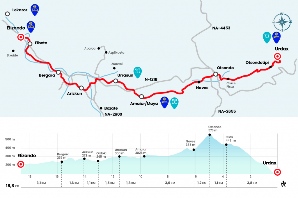
Information about the stage 3: Urdax to Elizondo Stage
Enlarge map
The route
- Km 0. Urdazubi/Urdax(Hostel. Bars. Pharmacy)
We face the first serious mismatch of the Camino: the port of Otsondo. Its deciduous, thick and easy bruma forest has witnessed caravans of merchants, passage of armies and also kings. We go back to our steps, cross the Ugarana again and turn right next to a seabed. Hidden under the weeds, it was discovered in a field of work. Frequent in the rural world, limestone rocks were calcined in these furnaces to obtain lime, widely used in construction and agricultural tasks. The first section of the port, with strong ramps, we do it on a rough track, animated by the stone landmark that marks 763 kilometers to Santiago. Here we already enter the limits of the valley of Baztán, the largest municipality of Navarra.
When we reach the Otsondotipi diversion, we continue right. Fortunately, from now on on forest track (Km 1.1). The path is clear and the landscape is sovereign. The port has a 9.7% average slope and 45 minutes later leads us to cross a runway. We immediately draw a portillo (Km 3,8) and continue climbing to a path dotted by the Saroiko race (Km 4,2). After a sudden turn to the left we approach the pinar and the hayedo to the merendero, where he well desires a break. Finally we left right on the high to the N-121-B (Km 4.9).
Let's cross the road to take the diversion to Gorramendi, and, look!, as soon as the Canadian crossing, a stone milestone from Cesáreo Soulé guides us right down a path. Please note that more than one pilgrim has skipped this detour. The dizzying descent begins. On the right, after the allergens, the picuda figure of the Alkurruntz stands out, a reddish summit of 934 meters. Numerous arrows guide the downhill, now wide and bose, now narrowing a zigzag along the hillside. The Baztan Valley opens way. At the bottom, on the left, the summit in Gorramendi, rich in megalithic monuments and with various telecommunications antennas; more at the forefront, the Autza, the mythic summit, custody of a valuable treasure, of 1305 meters.
After passing through a stream for a rustic step we went out to a cement trail, next to some livestock vessels (Km 6.1). Even with brief shortcuts between the stand, the paved track advances between scattered villages and leads us in 40 minutes to Amaiur/Maya. The chapel of the Pilar enters this road town, where in 1522 two hundred Navarros, in advance of recovering the kingdom conquered in 1512 by the troops of Fernando the Catholic, finally surrendered after a long siege. The remains of the fortress where it took place are seen in an altozano, on the right hand, where a monolith unfolds. Maya also offers several palatial houses, such as that of Borda, 1702. Many of the baztandarras constructions are dressed in this rosacea sandstone, common in its geology. We pass by the plaza, where is the social bar, which welcomes in its attic the hostel.
- Km 9.7. Amaiur/Maya(Bar)
At the end of Calle Mayor we went under its characteristic arch, leading to the cruise and church of Nuestra Señora de la Asunción. We left the village next to the rehabilitated mill and went out to the N-121-B. In 150 meters we leave the road through the right wing and take the road to Urrasun: a grim road beneath the chestnut, the old stretch or the real road. The spacious views of the valley now impress even more, with the mole of the Autza left hand. At the entrance of Urrasun, neighborhood of Azpilkueta, is the hermitage of Santiago. He rescues Father Germán that “in 1670 the hermitage was in need of repair”. Its lucid bearing is due to the rehabilitation works of 2007-2008.
- Km 11.5. Urrasun
The passage through Urrasun recalls the modus vivendi in the houses of yesteryear. The cattle were available on the ground floor, in the middle of the house and on the upper floor the loft, which served as a storage room for the feed and forage of the animals. We say goodbye to the rural neighborhood and then we take a detour to the right. The road surrounds the perimeter of the Mendialde estate, delimited by thick walls, and descends to the N-121-B after crossing a regatta. We crossed with caution and pulled forward by the NA-2600 towards Arizkun. We pass the polygon of the Ordoki neighborhood, where we can taste a tasty menu of the pilgrim on the grill. On the left is the manor of Ursua, the birthplace of the 16th-century conqueror. Notice, after the grill we turned 90º to the right and reached the Berroa Bridge to save the Baztan River for the first time. It was restored by the Association and Cesáreo Soulé, which complemented it with a source. A section of road finally ascends to Arizkun, an illustrious town in the valley where we have bar, shop and several pensions.
- Km 14.1. Arizkun(Pensions. Bar. Store. Pharmacy)
In the center we have the opportunity to divert a few meters to see the temple of San Juan Bautista, the eighteenth convent of Nuestra Señora de los Angeles, inhabited by some clear sisters, and also the stone carving workshop of the named Cesáreo. We go off the road and about 600 meters away, pay attention, we cut a horseshoe curve and we take a path to our left. It crosses a regatta and ascends between the stand on a road. After fleeing to the road we took a runway to the Bergara district, with its Cape Armory Palace, fortified (Km 15,7).
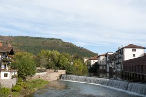
We landed on the N-121-B (on the right hand there is a merendero and another rehabilitated calera) and we traveled 800 meters through it, leaving it on the left. A runway parallel to the Baztan River approaches to the first houses of Elbet. On the right hand we can see the 17th century Baroque Jaurola Palace, which was the solar of Miguel de Vergara, captain of the Royal Navy and knight of the Order of Santiago. A construction that seems not to have affected the passage of time. Behind the road we enter the center of the Elbet and come to receive us the church of Santa Cruz, a former hospital of dryers, pilgrims and poor, already documented in 1288. The Baztán River divides Elbet de Elizondo, the valley capital with all amenities. There is a private hostel.
· Km 18.8. Elizondo (All Services)
The difficulties
Remarks
In images
What to see, what to do
The hostels

¿Do you want to send any photo of "The Camino de Santiago"?
If you have any photos of "El Camino de Santiago" that you want to share with us, you can send them to us and enlarge the photo gallery
Forum: What pilgrims think about the Camino de Santiago
See all