Article translated by an automatic translation system. Press here for further information.
Olagüe to Pamplona
In the medieval bridge of the Trinity the Baztanés connects with the French
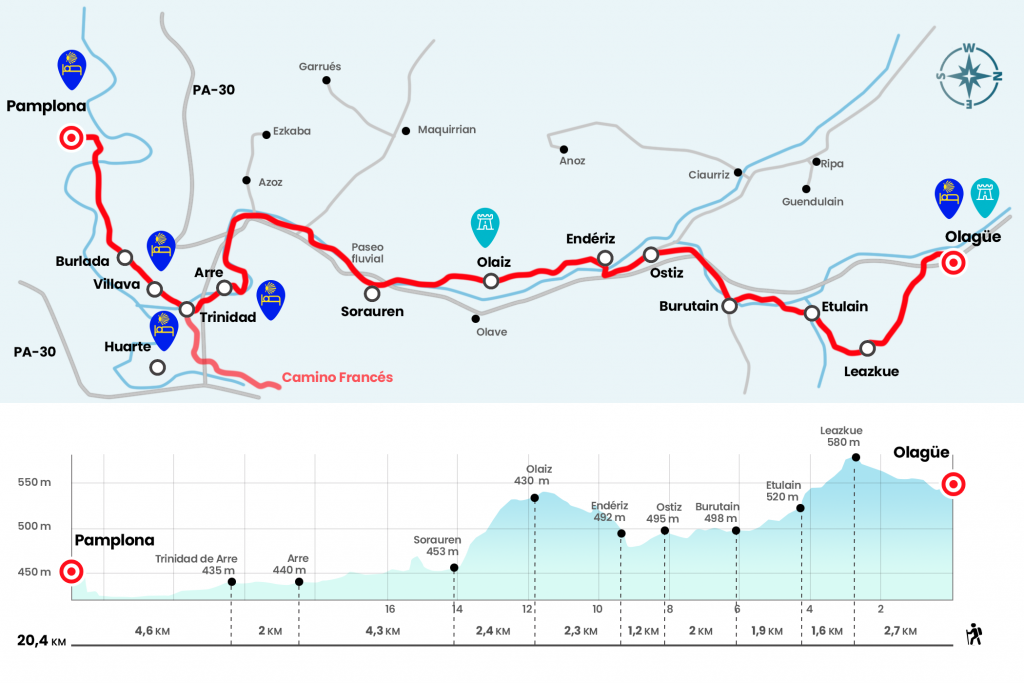
Information about the stage 6: Olagüe to Pamplona

Enlarge map
The route
- Km 0. Olagüe(Hostel. Store)
At the exit of Olagüe we take the road towards Iragi and Egozkue, which passes under the N-121-A, but soon we continue to the right by the NA-2521 which heads to Leazkue. It is a short road that crosses a plain area of grasslands fed by the Etxaide race. Leazkue is the smallest town in the Anué Valley, represented by the church of Asunción (Km 2,7).
- Km 2.7. Leazkue
At the end of the population we took a gravel trail that opens back to the countryside, with beech tupids in the upper parts and oak barrels on the edges. This beautiful landscape leads us to Etulain, with the parish dedicated to San Esteban and some renowned homes.
- Km 4.3. Etulain
As we leave the core, we cross the Telleki Regatta and take the path to the right, usually seized. It advances to the bridge and the Sale of Etulain, where we cross the Middle River (Km 5.1).
Let's walk around the meadow, but then we don't go to the road (there's a gas station) but go left to an abandoned house covered with graffiti. The Camino progresses along with a fish farm also in disuse and passes between chalés. We take the road to the left and at 350 meters we take a piste to the right, leaving Burutain on the other side of the river on a plateau.
- Km 6.2. Burutain
The trail leads to save under the N-121-A and through the NA-8109 we enter Ostiz, the road town of the Odieta Valley until a few years ago crossed by the general road. His church of St. John the Baptist is on horseback between the Romanesque and the Gothic and also boasts of several 16th century houses such as Casa Iriartea and Casa Gartxotena.
- Km 8.2. Ostiz
The access road goes down to the entrance roundabout to Enderiz, in the Olaibar valley. We climbed to the core after crossing the Ultzama River, which we already waited yesterday in the mountains of Belate.
- Km 9.4. Enderiz
At the top we turn left onto Errekaldea street and at the end of it a path emerges between the boj. A beautiful stretch begins, although a short time it rains we will be well served with mud. Through the hillside, saving several portilles and guarding the pine, we reached Olaiz. On the right is the temple dedicated to its San Miguel patron.
- Km 11.7. Olaiz
We also leave the population on a narrow path and between pine laricio and boj we begin the descent towards the Ezcabarte valley. Already by the Ultzama the river park begins. Before we can make a stop and cross the beautiful bridge of four arches of medieval origin to visit Sorauren. According to a 1565 document, this was one of the vouchers where the portazgo was charged for the traffic of the wood. In a straight line to the bridge, the modern parish of San Andrés emerges, which in 1906 supplanted the Romanesque style. There is bar-restaurant in the mythical inn (closes on Monday).
- Km 14.1. Sorauren(Bar-Restaurant)
The next six kilometres run through the river park of the Ultzama River, which, along with the Arga and Elorz rivers, forms a green space of 33 kilometres mainly for leisure and sport. You just have to follow the paved lane. In the vicinity of the campsite Ezcaba we left a few meters to a road (Km 15,9) to cross the river and continue the march. Later we began to see the industrial estate of Ezcabarte and spent a few times under the Ronda de Pamplona (Km 17,7).
Parallel to a polygon street we pass under a bridge where the walk is cut. We go left to the core of Arre and at this point there are two valid itineraries. The first is to continue the walk along the other side of the river, which gives a considerable rodeo due to the meander. The other option, much shorter and more attractive, is to reach the old part of Arre and cross the river through the Old Bridge, where it joins the river promenade.
- Arre(Bars. Shops)
In 12 minutes we stood by the medieval bridge of the Trinity, where the Baztanés Road connects with the Camino Mayor or French (Km 20,4). On the other side of the medieval bridge is the old Hospital of the Trinity, today also hostel for pilgrims with its annexed Romanesque basilica. The French Way continues in a straight line through the major streets of Villava and Burlada and then reaches the Arga River on the Magdalena Bridge (Km 24).
At the exit, on the left hand, is the diversion to the hostel Casa Paderborn. The Camino continues to the right towards a step regulated by traffic lights and the wall pit, next to the Baluarte de Nuestra Señora de Guadalupe. After the Levadizo Bridge and the Portal of France in 1553, we entered Calle del Carmen, where is the private hostel Casa Ibarrola. At the end of Navarrería Street the signs encourage us to turn left on Curia Street and then right on Compañía Street, where is the hostel of Jesus and Mary.
- Km 25. Pamplona(All services)
The difficulties
Remarks
In images
What to see, what to do
The hostels

¿Do you want to send any photo of "The Camino de Santiago"?
If you have any photos of "El Camino de Santiago" that you want to share with us, you can send them to us and enlarge the photo gallery

Forum: What pilgrims think about the Camino de Santiago
See all