Article translated by an automatic translation system. Press here for further information.
Berroeta to Olagüe Stage
Two-thirds of the stage run through wooded and half-mountain areas
Information about the stage 5: Berroeta to Olagüe Stage
Enlarge map
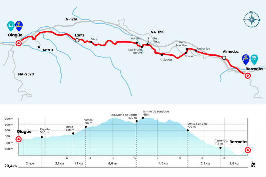
The route
- Km 0. Berroeta(Hostel)
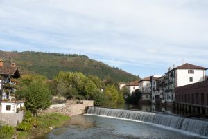
We traverse Berroeta Main Square and south-west heading down to the NA-121-A, which we save through a tunnel. A gravel runway then wipes between meadows and saves the Marin regatta. Then we began to climb up the Zalditz site, surrounded by lush vegetation sheltered from the chestnut tree. The path leads to the entrance of Almandoz, Here stands the modern church of San Pedro, of 1956, which retains elements of the old parish, in ruins at its feet (Km 2.4).
- Km 2.4. Almandoz(Bar. Store)
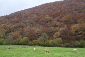
The only service of the village is a bar-restaurant (opens from 11:00 and closes on Monday), located in the 18th century Galtzaga Palace. We passed through the village and continued along the old road about 700 meters more. When we reach a curve, we go out on the right and continue the ascent on a paved runway. After a wooded section we left the road for 150 meters and left it on the right crossing a Canadian pass (Km 4.6). Forest through us again reaches the road 500 meters above, where the Venta San Blas is located. The inn keeps alive the flame of the old Hostel of Dryers and Pilgrims, located in this same place. At the door dintel we see the relief of a fellow, a bird coveted by hunters who usually meet here often.
- Km 5.3. For sale San Blas(Bar-Restaurant)
As soon as we go through the Sale we cut off next to the source of San Blas, on the same curve, on a steep path that goes back to the NA-1210. Pay attention because right here we cross the road and enter the forest. After the first ramp we jumped a portillo and continued from the front (eye, do not follow left on the clearest track). Going up in zigzag on Mount Larrondo we pass along with a few herds and a warehouse. The wooded path becomes a runway and runs through Mount Arluz, where there are usually parked cars (Km 6,8).
We go down slightly for half a kilometer, seeing that in the case of distress we have the relief of the road, which runs 80 meters below. Under our feet, remains of road begin to emerge, which has been renovated in several times. The trace may be of Roman origin, but there is no established consensus on this. A few meters later we pass next to a dazzling stream (during the rainy season water will come down by the presence of a stream). Seven hundred meters later, we left the forest to enter a clear area, where we reached the peak.
Here the road is bounded by a few vertical milestones. Within 10 minutes, we crossed a track and paid attention to that point. After the left mound is the hermitage of Santiago, rehabilitated not without great effort, as the works were delayed due to several collapses caused by adverse weather conditions (see observations). Father Germán writes in his Pilgrimage Road that “in 1791 the people of Almándoz raised a “Memorial to the Valley” asking for the reparation of this hermite-basilica, property of the Baztan Valley, because there was the danger of ruin because of the leaks and there was no solemnity to celebrate the sung Mass, accustomed to the festivity of the Holy Apostle.”
We enter the dividing line of the Atlantic and the Mediterranean basin and, after crossing the portillo that makes a muga between the valleys of Baztán and Ultzama, we winding down the road towards the hospital of Santa Maria de Belate, of the 12th century. Father Germán notes the episcopal letter of 1378, in which the bishop of Bayona don Pedro d’Oraich reported: “Infinite men would be lost and die in these mountains and forests, especially in the winter period… unless for the hospitality, food, assistance and guidance provided by the Hospital free and with breadth to all the visitors who travel there” (Km 9,8).
We will soon cross the Ultzama River, born in this same vaguada and which will flow into the Arga River next to Pamplona. The runway through the hayedo is clear for a bit, but then it blurs and we have to pay close attention to the yellow arrows. The Jacobean itinerary crosses the isolated wooded sites of Loiketa and Mendiburu for a couple of kilometers. The path finally breathes and the forest gives way to the bucolic landscape of grasslands surrounding Lantz, which is shown shortly (Km 14,4).
This town of road physiognomy is recognized throughout Navarre by its rural carnival, which has as its protagonist the bandit Miel Otxin, passioned, tried and burned in the stake by a group of masked people known as txatxus, accompanied by other characters such as Ziripot, Zaldiko and the Arotzak. We cross Lantz down Santa Cruz Street, where the inn is.
- Km 15.6. Lantz(Hostel. Casa Rural. Hostel. Bar-restaurant. Power Store)
At the exit we see the church of the Saints Cornelius and Cyprian. We resumed the walk along the access road, at the edge of the Eltzarrain or Medium River, and 20 minutes later we followed a path that arose from the front. It's tapped with blackberries, which are known here by the name of scratches. As soon as we cross the Beltx race (Km 18,3) we turn left hand and take another road to the road that comes from Arizu, which we follow to the right. We entered Olagüe, capital of the Anué Valley. The pilgrim hostel is located in the parish house, next to the Baroque church of San Juan Bautista.
- Km 20.4. Olagüe(Hostel. Bar-restaurant.)
The difficulties
Remarks
In images
What to see, what to do
The hostels

¿Do you want to send any photo of "The Camino de Santiago"?
If you have any photos of "El Camino de Santiago" that you want to share with us, you can send them to us and enlarge the photo gallery
Forum: What pilgrims think about the Camino de Santiago
See all