Article translated by an automatic translation system. Press here for further information.
Bayona to Ustaritz
This stage has no difficulty and can be completed in three hours
Information about the stage 1: Bayona to Ustaritz
Enlarge map
The route
Introduction:
“The pilgrimage was intensely felt in Bayonne, the hostels were numerous, the living faith and the friendly hospitality, the houses were open to the pilgrims and looked on the facade a shell.” Luciano Huidobro in The Jacobean Pilgrimages
Bayona collected some walkers from the Via Turonense, which brought together pilgrims from northern Europe in Paris, and also witnessed the landing of pilgrims by sea. Many of them, as an alternative to the ports of Cize, continued to Irún, where they took the Camino del Norte or the Camino Vasco del Interior and the Via de Bayona, after Aizkorri and the San Adrián tunnel. Other pilgrims, as is our case, were betting to join the French Way next to the Trinity of Arre, at the gates of Pamplona, following the lush and picturesque route of Urdax and the valley of Baztán, with lighter ports such as Otsondo and Belate. A Jacobean itinerary that began to recover in 2000 the Association of Friends of the Camino de Santiago in Urdax-Baztán, guided above all by El Camino de Peregrinación Jacobea: Bayona-Urdax-Velate-Pamplona, a research work by Father Germán de Pamplona that published in the 1960s the Prince of Viana Institution.
The itinerary:
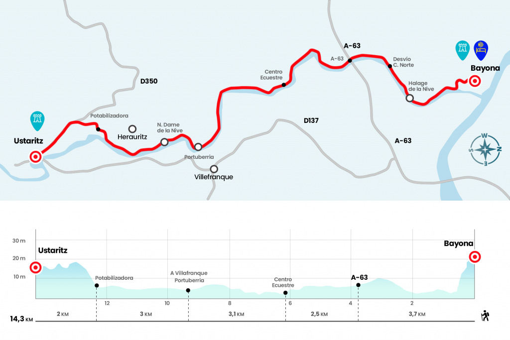
- Km 0. Bayona(All services)
The Baztanés Road begins at the front of the Gothic cathedral, from the 13th to the 17th centuries, where we can request credential and seal (see observations). The output is simple, but it lacks signalling. We head towards the street surrounding the beautiful cloister – it is on the right of the cover – and behind it we turn left by rue de Luc. It ends up in the commercial and animosa rue d’Espagne, which we follow right to the end, where we take left, descending, rue Tour de Sault. When we reach the Nive River, we don't cross it, we turn right into the traffic light and go back through the promenade.
Almost the entire stage will be like this, with the river glued to the left. On the same walk, before passing under André Grimard Avenue, there is a post that shows the three possible Jacobean paths from Bayona. It will be the only one of these proportions, since from now on those responsible for guiding us on the French side will be discreet Jacobean stickers. At the moment, our itinerary, indicated by the Voie du Baztan, follows the same steps as that of Saint Jean Pied de Port (Roncevaux) and Irún (Voie de la Côte) (Km 0.7).
Half a kilometer later, next to several sports fields, the route passes under the rail bridge (Km 1,2), where the placid la Nive begins to draw smooth meandering. Soon the ride is called Chemin de Halage de la Nive, which is translated by Camino de Sirga de la Nive. The name of the path of sirga alludes to the path parallel to the path from which the shooting beasts, usually mules, carried the merchant barges. Now, holidays, ramps, cyclists and skaters.
Almost a kilometer later, the Camino de la Costa, travelling to Saint Jean de Luz e Irún, dismisses on the right by taking the Rue du Docteur Voulgre (Km 2.7).
Residential areas with clear facades and colourful windows flush this Sirga Road, which passes under the A-63 highway (Km 3.7). Half an hour later, after several meanders, we arrived next to an Equestrian Center, which has the restaurant bar L’Heverge de la Nive (closed on Tuesdays). To Ustaritz is the only place next to the Camino to take something (Km 6.2).
The day progresses rapidly and without startles, as glued with Loctite to the river, orchards and crops and its rich riverside vegetation. In the place of Portuberria, one of the enclaves prepared for loading and unloading of goods, we passed the walkway that accesses Villefranque, a town that in the 14th century was the scene of murders and serious disputes between Bayona and Basque neighbours, precisely by the transport and sale of products (Km 9,3). One kilometer later we arrived at the place of Notre Dame de la Nive, where we left to the right the diversion to Herauritz (Km 10.3). We continue on the left, by the stream, and we arrive in another 25 minutes to the potabilizer, where we definitely leave the river (Km 12,3).
We head to the right and go to the Chemin Leihorrondo, which we take to the left to reach after a few steps to the road of Ustaritz. Rue de Hiribehere enters this locality whose toponym can be translated by plain oak. In the center is the church of St. Vincent, of the 19th century, as well as the next castle Lota, raised by Indians.
- Km 14.3. Ustaritz(Hostel, Cottage. Bars. Shops. Pharmacy. ATM)
The difficulties
Remarks
In images
What to see, what to do
The hostels

¿Do you want to send any photo of "The Camino de Santiago"?
If you have any photos of "El Camino de Santiago" that you want to share with us, you can send them to us and enlarge the photo gallery
Forum: What pilgrims think about the Camino de Santiago
See all