Article translated by an automatic translation system. Press here for further information.
Zerain to Salvatierra Stage
Without more kilometers of industrial penance, we enter the Alavesa Plain
Information about the stage 4: Zerain to Salvatierra Stage
Enlarge map
Points of interest in the stage 4: Zerain to Salvatierra Stage
The route
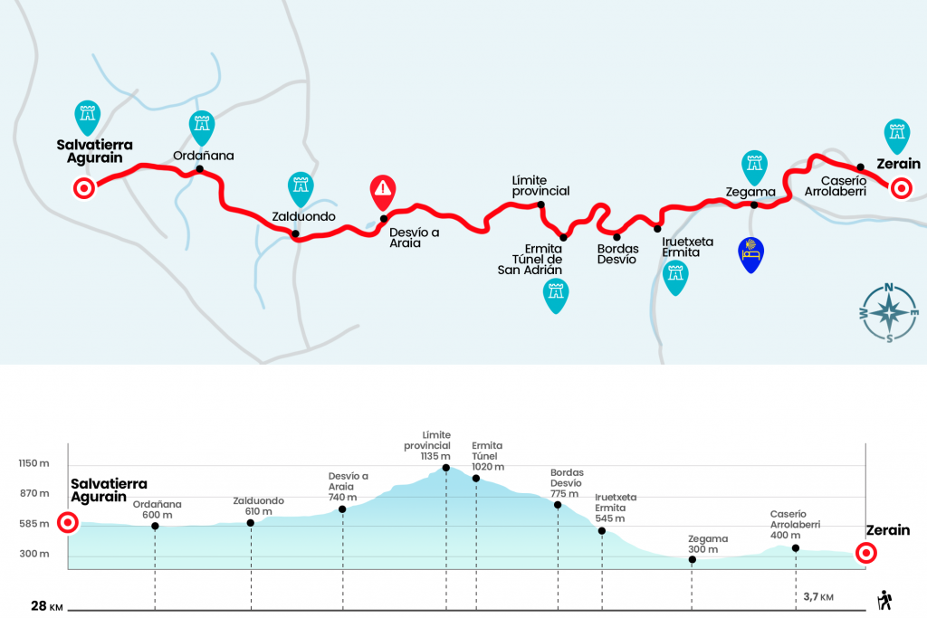
With the peaceful rural calmness that Zerain brings, far from the narrow and saturated industrial corridor that accompanies the middle course of the Oria River, we are preparing to begin the symbolic stage, let us call it the Camino del Interior. The passage of San Adrián and the lands of Álava are relatively close, so without a hurry but without a pause we start from the church of Santa Maria, leaving the facade of the Jauregui palace on the right hand. Soon we left the paved track on the right and took a grassland to pass a portillo and then a stream. After this, there is a small part (trust the red and white marks of the GR), which will be followed by two other portilles. We go down to a paved runway but we leave it quickly on the left to take a path that borders a pine tree. After another portillo that cuts us the step, we continued, later found another door that we also went through. This initial route engages, walking along the hillside of the lush valley and with the views of the Aikorri mountain at the front. We will reach a paved runway, where is the Caserío Alorraberri (Km 2.7).
The runway goes up to the road GI-3251, which we leave immediately on the right to deviate to the left hand by a pinar, which accompanies us in the descent next to a regatta. The nice walk is aborted again on the GI-3251 (Km 3.8), which will take care of driving us to Zegama. Before we cross our beloved river Oria to enter the district of Ondarraldea, where we take to the right the GI-2637 to reach Zegama. We pass by the facade of the parish of San Martin de Tours (Km 6,3) and leave the population in the same way we enter: GI-2637. We continue through it for more than a kilometer to Iruetxeta (Km 8) where, definitely dismissing from the Oria, we take the cement trail that is born to the right of the road. The slope becomes stronger and we advance the runway that uses some horseshoe curve to save the slope (on the first curve do not take the runway that goes to the right). On the hill is the chapel of Iruetxeta, which houses a size of the Virgin of the XIII-XIV centuries (the owners of the house have the keys (Km 9.5).
Two hundred meters higher is the Buenavista farmhouse and, in front of it, we turn left to leave the track and take another one of uncomfortable gravel. After a fence the gravel disappears in favor of a more mountainous terrain. Looking back, we will have a good overview of the road and Zegama, anchored in the middle of the valley. After another pair of portillos, with a flat area between them, we will reach up to two bords (Km 11), we go between them and turn to the right (eye at this point because there is a hint that goes on the left) to enter the forest. After half a kilometer we got to a junction and we went on the left track. Kilometer and a half higher is the chapel of Sancti Spiritu, old pilgrim hospital. Through the remains of a road we are decidedly heading towards the San Adrián Tunnel or Lizarrate Pass, facing the eye. It is a natural passageway, not created by the hand of man, that crosses the limestone rock of the Sierra de Aizkorri. We entered one of the gates of the old fortress that guarded the passage and passed by the chapel of San Adrián to "breathe?" again through the other tunnel mouth (km 13,8).
At the exit there is a quiet corridor to rest. Good time for this because the bulk of the climb is more than overcome. The rest is pure formality. We continue along the medieval road that makes a curve to the left (marked by the inscription "Camino de Santiago?") and through it we will reach the high and say goodbye to Guipúzcoa to enter Álava (Km 14.8). The limit is not marked and we will go very close to the worn yellow arrows. One of them makes us descend right to a track, where we find the first yellow beacon placed by the Association of Friends of the Camino de Santiago de Álava. A more blurred section leads us to the paved runway that will be our guide from now on. At two kilometers a shift to the left towards Araia, which we did not take, emerges, and on the right hand a double signal gives us the choice between continuing to Zalduondo by road or by the asphalt track we bring (Km 18,5). This last option is four hundred meters shorter, so we're continuing like we've done so far. A kilometer further down we set aside a small lagoon and continue in the direction of Zalduondo (left to Araia). After a Canadian step and the diversion heading to the hermitage of San Julián and Santa Basilisa, the former parish of the depopulated Aistra, we finally reached Zalduondo (Km 21,7).
We surround the church of St. Saturnino of the 16th century on the right and then turn left to take the road A-3018. Through it we go to Ordoñana, passing by another raft of water and leaving aside the hermitage of San Millán. Ordoñana (Km 25) is abandoned for the same A-3018 that will converge with the A-3016. By the latter we finally reached Salvatierra/Agurain. We cross the Zadorra River and in the direction of the Historical Quarter we leave the cover of the church of Santa Maria to the left, accessing the Calle Mayor next to the house of Azcarraga At the end of this street we go to the porticated plaza of San Juan, presided by the church of the same name (Km 28). To reach the pilgrims' hostel, opened in July 2013, there is nothing else to follow the signs to the Portal del Rey and Calle Fueros.
The difficulties
Remarks
In images
What to see, what to do
The hostels

¿Do you want to send any photo of "The Camino de Santiago"?
If you have any photos of "El Camino de Santiago" that you want to share with us, you can send them to us and enlarge the photo gallery

Forum: What pilgrims think about the Camino de Santiago
See all