Article translated by an automatic translation system. Press here for further information.
Stage of La Puebla from Arganzón to Haro
The Ebro River and the vine fields announce the proximity of La Rioja
Information about the stage 7: Stage of La Puebla from Arganzón to Haro
Enlarge map
Points of interest in the stage 7: Stage of La Puebla from Arganzón to Haro
The route
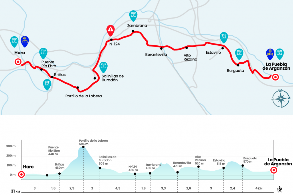
We started the seventh and penultimate stage through Santiago Street, leaving the Plaza Mayor and the Gothic church of the Nuestra Señora de la Asunción to the left. On one side we also leave the hospital of San Juan and the hermitage of the Virgen de la Antigua. Just before reaching the urbanization you have to twist left hand - next to the marquesina - to cross the bridge over the train tracks. After him we took the deviation from the right that marks Burgueta, Pangua and Manzanos. It is a secondary road from the A-1, with only a single meaning and with little traffic moving parallel to the railway. We drove through it to the petrol station and the Burgueta restaurant, and on the roundabout we continue left towards that locality. Then, after the step under the A-1, we turn right onto a track which, parallel to the highway, leads to a road. We went up to Burgueta (Km 4).
In the population we discover the parish of San Martin and when we reach a fountain we turn right to take a trail that moves us away from Burgueta, the last town in Treviño County on the Camino. Once again in Álava we find the signs of the Basque Government. Surrounded by farmland we reach a cross of roads, where we go ahead and descend to Estavillo (Km 6.4). The route leaves the bulk of the town aside and leaves it by the access road. At this point you have to pay attention and get out of the road on the left (not indicated), up to a nearby sign and a pin that you can see with the naked eye. We must go ahead, taking into account the indication Camino de Santiago by the Rioja and taking as reference, in the distance, the toll of AP-1. The Right-hand Cairn takes the route of the Via de Bayona, which is directed towards Armiñón, Miranda de Ebro, Pancorbo, Briviesca, Monasterio de Knee and which links in Burgos with the French Way (see section observations).
On an agricultural track we head towards the AP-1 toll, which we left on the right hand. A kilometer and a half later we crossed the A-4105 secondary road and faced the echo of the high of Lezana, crowned by a telephone repeater (Km 9,4). After the short descent, the trail rides on undulating slopes that mark the limits of cereal and sugar beet plots. Later it emerges in the distance, after the line of trees that pull the route of the river Ayuda, the tower of the church of Berantevilla. After passing the river we left this Alavesa town on the left hand (Km 12) and crossed the road by a stone cruise and forge. We turn left and enter Berantevilla. There turn right onto Calle Mayor, we will pass under the highway, we will turn right parallel to it and after 450 meters, we will turn left to go up the piste. It also gives a small truce before undertaking the hardest part, which begins after a turn to the left. We reach high in a clearing where fruit trees grow (Km 14). Zambrana is a stone's throw away and, after the descent and ignoring a discolored and badly placed yellow arrow that indicates to bend to the right, we border the cemetery and go to the church of Saint Lucia, where they kindly seal the credential (Km 15,3).
We leave behind the church to continue along Calle Juan de Lazcano and leave Zambrana on a paved runway where we are fired by another stone and forge cruiser (this section of the Basque Way of the Interior coincides with that of the Camino del Ebro GR-99) After crossing a comarcal highway the runway becomes parcel and after eight hundred meters we arrive at the ruins of the Sale. Shortly we arrived at the arcén of the N-124 (Km 17.2) and irremediably continued through it. It is a very busy road, especially by trucks, and it moves along with the AP-68 and the Ebro River. After almost two kilometers of arcén we left the N-124 next to the facilities of an old Yesería with an octagonal tower. As from nothing arise vine fields which are neglected by the slopes and which announce the proximity of La Rioja. Not in vain a runway with ups and downs leads us to surround Salinillas de Buradón, the last Alavese people of the Camino. The itinerary does not enter the historic center but it is worth taking a break and accessing through the northern gate of the wall to discover this locality (Km 21,5).
We left Salinillas de Buradón on a runway in a steep ascent, to the right of the upper San Cristobal and still coinciding with the GR-99 route. Two kilometers wrapped by a tupid Mediterranean shrubland lead to the portillo of the Lobera, step and watchtower where you can see how the lower mountain melts with a landscape of vines surmounted by the Ebro (Km 23.5). First, Briñas stands out, something beyond Haro and as a backdrop to the Sierra de la Demann. In the same step there is an indication for cyclists: BTT eye. Dangerous descent! In fact, the descent saves a strong slope and reaches a wearer area sown with vineyards. A metal sign that shows on a sketch the itinerary of the Camino del Interior from here to Santo Domingo de la Calzada, marks the provincial limit between Álava and La Rioja (Km 25). Two paths emerge after it: that of the left directly to Briñas, that of the right, longer and coinciding with the GR-99, gives a slight rodeo, passes by a jurisdictional picotta and enters Briñas next to a roundabout of the N-124 and the Portal de La Rioja hotel. Both variants are correct. Once in Briñas (26.4), we went under the tower of the church of Concepción and continued along Solana Street to the paved runway that advances parallel to the Ebro. With the pleasant river company we reach the medieval bridge of Briñas (Km 28), which we cross to follow by paved runway until the entrance of Haro. Along Avenida de Vizcaya we reach a step under the railways and then we continue in the direction of Centro Urbano. Along the avenue of the Costa del Vino we cross the river Tirón to climb the street of Navarra to the plaza de la Paz.
As soon as we arrive - attentive to the shells placed on the ground - we fold to the right next to the Swiss coffee and again to the right by the street of la Vega. After passing the basilica of Nuestra Señora de la Vega, patron of Haro, we continue on the left by Calle Castañares de Rioja until the roundabout. We take it forward to enter Plaza Bartolomé Cossio and turn left onto Avenida Juan Carlos I, where the pilgrims' hostel is located (Km 31).
The difficulties
Remarks
In images
What to see, what to do
The hostels

¿Do you want to send any photo of "The Camino de Santiago"?
If you have any photos of "El Camino de Santiago" that you want to share with us, you can send them to us and enlarge the photo gallery


Forum: What pilgrims think about the Camino de Santiago
See all