Article translated by an automatic translation system. Press here for further information.
Stage from Vitoria/Gasteiz to La Puebla de Arganzón
Journey south through Gometxa to Treviño County
Information about the stage 6: Stage from Vitoria/Gasteiz to La Puebla de Arganzón
Enlarge map
Points of interest in the stage 6: Stage from Vitoria/Gasteiz to La Puebla de Arganzón
The route
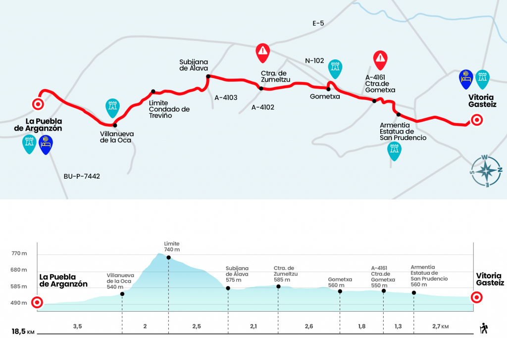
From the Cathedral we descend on Fray Zacarias Martínez to the Plaza del Machete, once we descend to the Plaza de la Virgen Blanca and from there we continue to the Plaza del General Loma, straight through the park of La Florida until we pass under the tracks of the train, we continue to the right along the promenade of Fray Francisco de Vitoria to continue to the end of this Then we went to the 12th century Romanesque basilica of St. Prudencio of Armentia. From this period conserves the semicircular apse, the cruise and decorative elements. In 1776 there was an important reform of the complex, currently surrounded by a nice park with rest areas, sinks and fountains. After passing the Basilica of St. Prudencio, it continues straight through the Pilgrim's Walk to connect with the A-4164, secondary road glued and parallel to the N-102 (Km 4).
We arrived at Gometxa (Km 5,8), a town already documented in the 11th and 12th centuries. After his neoclassical church of the Transfiguration we continue on the right by a paved runway and leave the locality next to a gambling hall. The fields of sowing and the parcels that flow through them are witnesses to our passing through these lands. In past centuries pilgrims and travellers linked Vitoria with La Puebla through Ariñez, today flanked by the N-102 and the A-1, or by the Zadorra River. However, today it is not worth saying that of 'any past time was better'. The routes change at the whim of the times and the Roads to Santiago that today travel the national geography will also be studied, of course, in the coming centuries. Two kilometers and six hundred meters after Gometxa we cross the A-4102, a road that connects the localities of Zumeltzu - up to the left - with Ariñez. (km 8.4)
Two kilometers later we entered Subijana de Álava (Km 10.5). Apart from the most notable church in San Estebanlo of this population is the stately house of Anda and Salazar. It is baroque, from the late 18th century and was the residence of the Anda and Salazar family. The son, Don Simon, was the governor of the Philippines and his stay in the Asian archipelago is remembered on the shield of the facade, which shows an elephant at the bottom. We surround the palace and, behind the fountain, we take a path that ascends. At about 250 meters ' attentive - you have to twist right hand and face the hardest part. The repeat is brief and it is appreciated that the rest of the climb does not follow any pattern, as the alternate path alternates false plains with small sections of more slope. Pines, bladders, twisted oaks and even cubes that grow on a tupid shrug open the path. When the carrascal is present and the weeds give way to the clearing we reach the high (Km 13). We are in the County of Treviño, territory belonging to Burgos and physically immersed in Álava. On a clear day you can see, at the front, the Sierra de Cantabria or Toloño and, closing the line of the horizon, the summits, often snowy, of the Sierra de la Demann. The descent, along a populated path of loose stone and Mediterranean Mount, is quick and saves a strong slope to reach Villanueva de la Oca (Km 15). At the entrance we can refresh ourselves in the fountain decorated with venera. At the exit, past the church of San Pedro - with Romanesque cover with rich details in archivolts and capitals - we take, on the right, the regional road that links with La Puebla de Arganzón. After two and a half kilometers of road we went under the A-1 and reached the entrance roundabout. In the urban center direction and next to the Zadorra River we enter La Puebla de Arganzón by Calle Concepción Sorkunde which leads to the same Plaza Mayor (Km 18,5).
The difficulties
Remarks
In images
What to see, what to do
The hostels

¿Do you want to send any photo of "The Camino de Santiago"?
If you have any photos of "El Camino de Santiago" that you want to share with us, you can send them to us and enlarge the photo gallery

Forum: What pilgrims think about the Camino de Santiago
See all