Article translated by an automatic translation system. Press here for further information.
Stage from Toulouse to Zerain
The Camino leaves behind the region of Tolosaldea and succumbs to the Goierri
Information about the stage 3: Stage from Toulouse to Zerain
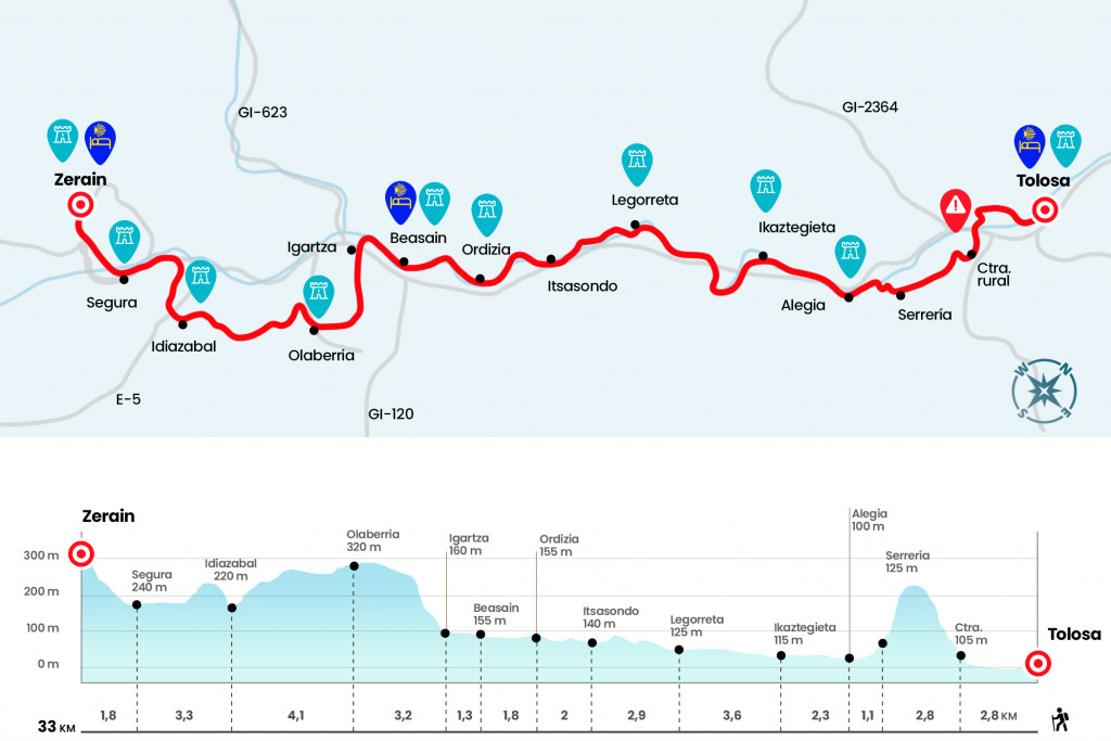
Enlarge map
Points of interest in the stage 3: Stage from Toulouse to Zerain
The route
Already used to rolling through the interior of the Basque Country, we face the third day before the Baroque façade of the church of Santa Maria. Leaving it to the left we reached the plaza where the Town Hall of Tolosa is located and after it (eye, not crossing the bridge over the Oria) we continued through Zerkausia Kalea to the square where the portal of Castilla is located and the former headquarters of the Provincial Council, from when Tolosa held the Guipuzkoan capitality. In this same place he rotates left hand to penetrate through a passageway that leaves next to the Oria. We follow the margin of the river and cross it through the second bridge we find, then advancing with the flow to our right. Glued to the river, we continue along the Iurramendi Promenade, village of townhouses and provided with bike lanes. At the end of the rail we crossed the Oria again by a pedestrian bridge. At this point the route has been modified, before the Camino was directed to Alegia saving a strong echo along a rural road and a steep descent by forest. It is currently recommended, after the bridge, to continue along a bike and pedestrian (bidegorri) rail that leads without loss to Alegia.
Optional: Those who want to test the old route to Alegia (still reflected in the stage profile), with little signage, hard and meaningless, surround the sports complex on the outside, follow the parking and turn left to pass under the A-1. They will enter the industrial estate of Usabal. As soon as you get access, you climb up the right in a strong echo and, with a more privileged view of the polygon, you reach a rural road born on the right hand (Km 2,8). On a hard climb they leave behind the hamlet Alejo Nea (Km 3.8) and continue in front. At the next bifurcation they choose the option on the right and 300 meters later leave the paved floor when they take a detour to the left. The Camino is injected into a robledal hayedo and, below, to the right, you can see and hear the transit of the A-1. The presence of pines announces the descent, which quickly overcomes a fitted path that leads to the foot of a sawmill (Km 5,6). Soon they will arrive near the church of San Salvador of Altzo Azpi and then enter Alegia, not without crossing the river Oria.
Both options go by the City Hall and the church of San Juan Bautista (Km 6,7). At the exit of Alegia we take the bidegorri that sticks to the asphalt of the GI-2131, a route that scrupulously follows the trail of the Oria River. Along with the Andarines, who religiously comply with their morning walk, and cyclists who take advantage of these lower traffic density roads, we are fulfilling the distance that separates us from the center of Ikaztegieta (Km 9). We will soon realize that the stage has become a monologue of itself. At the exit of Ikaztegieta we take the bidegorri of the GI-2131 and continue to Legorreta. We cross the Oria before reaching the center of this town, where is the church of San Salvador (Km 12,6). We are now officially in the Goierri region. The corridor we walk through is the only near-flat option in this valley of strong slopes and meadows that are discovered from the mountains. Towards Itsasondo more of the same: bidegorri and GI-2131. In the center of Itsasondo we reached the kilometer 15.5 of the stage and at the exit of the town we fired from the GI-2131 to take the diversion to Ordizia by the GI-4761. Without the protection offered by the bidegorri, we went next to the hermitage of San Juan de Lateran, prologue of Ordizia, a town famous for its weekly fair where the best products raised in the rural bowels of the Goierri are offered. We enter Ordizia through Filipineta Street, arriving at the Paseo de los Fueros, and continue in front by Calle Mayor (Km 17,5) and then by Calle Urdaneta, which meets the Oria and transfers the witness to Beasain. It melts from one town to another and passes through Beasain long, more after first crossing Ordizia. We must pay attention when we arrive next to the monumental complex of Igartza, on the edge of the Oria and recognizable by the stone bridge, the mill, the ferreria and the palace. Since June 2011 the Friends of the Camino de Santiago de Guipúzcoa manage a hostel of pilgrims at this point and it is already possible to divide this difficult stage. See availability in the comments section (Km 20,6).
The second ameno section of the stage finally comes, so we cross the bridge over the Oria and deliver the N-1 over a walkway, to take up a rural road that leads us next to the hamlet Altamira (Km 21,7), point where we drift through the right track to pass the Garitain farmhouse and finish the climb to Olaberria (Km 23,8). We cross the population and at the exit, by the road, we take a road that is born to the left hand and that leads us, after a turn to the left, to the dwelling Aldasoro. A signal is 3.3 kilometers to Idiazabal. On a paved rural trail we will reach later to the imposing manor house of Oiarbide (Km 25.9).
Then there will come a fountain with an inscription in Euskera and below the small nucleus of Nafarrasagasti, where we turn left on a road that reaches a stream and discovers the rough road Artsugarats. It brings us closer to Antia and the Gurutzeta Shrine.
A few meters away, due to the marked deviation, we walk down the road of Uzkanga, used by the neighbors of this area to go down to Idiazabal and formerly known as eliz bidea. You have to go down with caution because the skipping that saves makes it more of a ladder than a road. We arrived at Idiazabal, opposite the church of San Miguel, and we tore left. After the humiliation we turn on the first of the right, cross a regatta and, on a hard hill, cross the A-1 for an underground step to reach the viewpoint of Lobio, excellent watchtower over Idiazabal (km 28,5).
We resumed the march by track and, after several divers, we ended up with a roundabout of GI-2637. Due to the absence of signs at this point, we continue left by the bidegorri of this road to the same village of Segura (Km 31,2).
From Segura the Camino de Santiago departs through the portal of Zerain, and takes the bidegorri (bike lanes) that leads to Zegama. When the bidegorri ends in the Gozategi area, when it reaches an industrial estate, it crosses the road and follows a road that conditioned the town hall to the urban centre of Zegama, without touching the road at all.
This is the complete outline of the Tolosa–Zegama stage, prepared by the Basque Government.
The difficulties
Remarks
In images
What to see, what to do
The hostels

¿Do you want to send any photo of "The Camino de Santiago"?
If you have any photos of "El Camino de Santiago" that you want to share with us, you can send them to us and enlarge the photo gallery


Forum: What pilgrims think about the Camino de Santiago
See all