Article translated by an automatic translation system. Press here for further information.
Hernani to Tolosa stage
Far from nature, industrial sites come to the pilgrim's pass
Information about the stage 2: Hernani to Tolosa stage
Enlarge map
Points of interest in the stage 2: Hernani to Tolosa stage
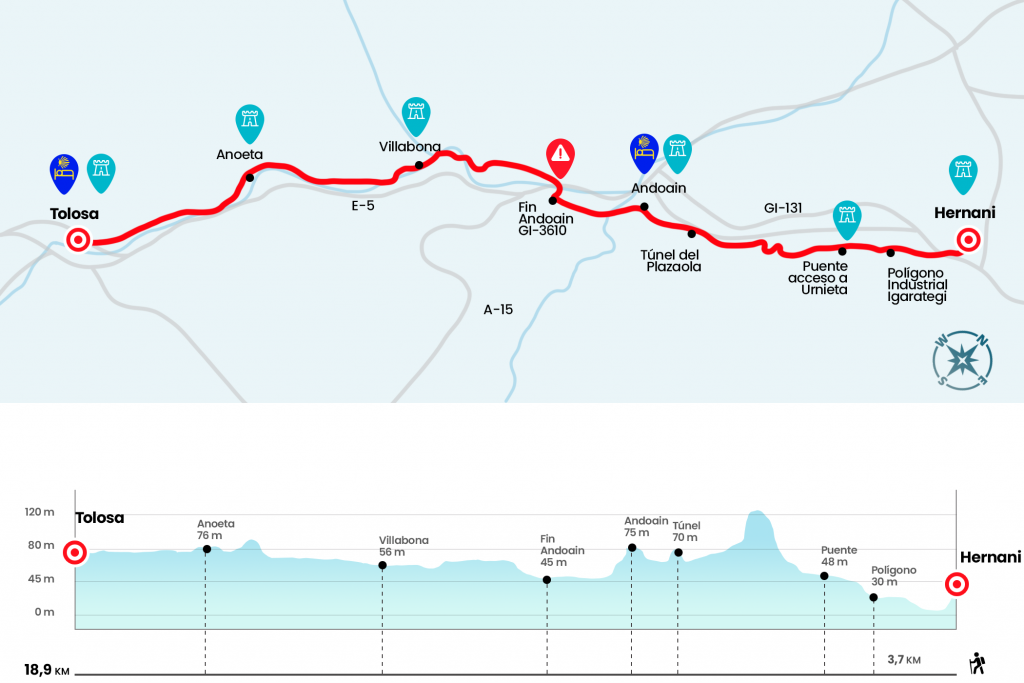
The route
In front of the facade of the Hernani City Hall is the second day, which runs a radically opposite of the initial stage. We traversed the Casa Consistorial by one of the portals that protected access to the old walled city and then took the stairs, on the left hand, that come down next to the humiliation of the Santa Cruz and after which we penetrated under the rail bridge. So we entered the Portu neighborhood. Two near-right detours, the last of 90 degrees, lead us along the channeling of a regatta and until the beginning of the bidegorri (alternative vial exclusive for cyclists and pedestrians) that leads to the entrance of Urnieta. Thanks to the bidegorri, which advances parallel to the train tracks, the route avoids the GI-131 road. The bidegorri leaves us by the industrial estate Igarategi (Km 1,8) and we continue straight leaving the tracks and Urnieta to the right. A marked deviation gives the option to access this locality by the bridge over the tracks (Km 2,8), however the official route passes through and continues straight and parallel to the industrial estate of Erratzu.
After a long straight we turn right and line a parking lot to climb stairs and tackle (following the yellow arrows and not the damn that forces to give a rodeo) to a runway. It takes us next to a company, which we surround to cross the GI-4721 and take a road that transports us to the Leizotz polygon (Km 4,9). After a long road through the outer street of the polygon we reached the tunnel of the train of Plazaola (Km 6), which was born with a mining vocation and also became a passenger train linking Pamplona with Lasarte and San Sebastián. In 1958 they dismantled the line and it has become a pathway for cyclists and pedestrians. Through it we reach Andoain, turning right onto Avenida La Salle to the Goiko plaza, which houses the church of San Martin, the City Hall and the pediment (Km 7). If we don't want we don't get in, but we're still left by Calle Mayor. We left it 600 meters below to cross the river Leitzaran, which melts with the Oria a few meters below, next to the chapel of Santa Cruz. We continue in front of the streets of Zumea and Aita Larramendi to the end of Andoain poster, where is the Izturitzaga House and where we must turn right to take the GI-3610 towards Aduna (Km 8.8).
We crossed for the first time the Oria River, the most prominent Guipuzkoan channel that will be the protagonist of the next stages, and we passed under the dense web of A-1 pathways. We continued through the GI-3610 and, later, passed the detour to Aduna (it seems that the route marked by the Basque Government took this detour and took an alternative route to Villabona. However, there is no indication of it. ). From the front, we will surround the exterior of a polygon to the bridge over the Oria, which forces us to turn left to cross it (Km 11,1). So we enter Villabona and parallel to the river we reach the Zubimusu Bridge, which separates Villabona from Zizurkil (Km 12,3).
After crossing the bridge, without entering Zizurkil, we turn left and march parallel to the river to approach the railways (the best reference). The only escape and leisure route the scaffolds have, due to the little space left by the N-1 route, the Oria River and the train, is an asphalted track attached to the tracks. It is also the one that guides our steps a long way to a level with barrier (Km 15). In short, thanks to two underground steps under the tracks, we enter Anoeta on San Juan Street to the church of the same name (Km 16).
A sign from the Basque Government marks 2.7 to Tolosa. We take the road on the left (GI-3411) that goes to Hernialde, although only a few hundred meters and we leave it on the left to pass under the tracks. We cross the GI-3650 and continue along the arcén by the Benta - Aldea polygon. Before entering Tolosa we passed the crossing to Hernialde by GI-3412. From this point to Plaza de Santa María de Tolosa there is only about a mile (Km 18.9).
The difficulties
Remarks
In images
What to see, what to do
The hostels

¿Do you want to send any photo of "The Camino de Santiago"?
If you have any photos of "El Camino de Santiago" that you want to share with us, you can send them to us and enlarge the photo gallery

Forum: What pilgrims think about the Camino de Santiago
See all